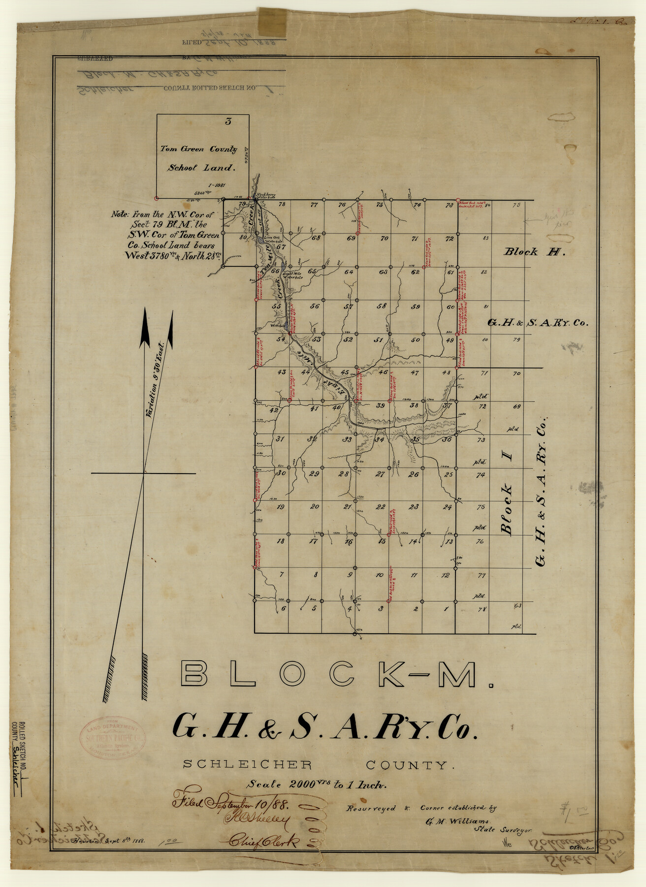
Schleicher County Rolled Sketch 1
Block M, G. H. & S. A. Ry. Co., Schleicher County
-
Map/Doc
7745
-
Collection
General Map Collection
-
Object Dates
1888/9/10 (File Date)
1888/9/8 (Creation Date)
-
People and Organizations
G.M. Williams (Surveyor/Engineer)
-
Counties
Schleicher
-
Subjects
Surveying Rolled Sketch
-
Height x Width
25.3 x 18.4 inches
64.3 x 46.7 cm
-
Medium
linen, manuscript
-
Scale
1" = 2000 varas
Part of: General Map Collection
Flight Mission No. CRC-5R, Frame 44, Chambers County

Print $20.00
- Digital $50.00
Flight Mission No. CRC-5R, Frame 44, Chambers County
1956
Size 18.6 x 22.4 inches
Map/Doc 84963
Montague County Sketch File 2

Print $24.00
- Digital $50.00
Montague County Sketch File 2
1856
Size 12.0 x 8.5 inches
Map/Doc 31711
Hockley County Sketch File 16

Print $20.00
- Digital $50.00
Hockley County Sketch File 16
Size 23.6 x 30.9 inches
Map/Doc 11774
Lavaca County Working Sketch 23

Print $20.00
- Digital $50.00
Lavaca County Working Sketch 23
1985
Size 37.8 x 39.8 inches
Map/Doc 70376
Armstrong County Working Sketch 7

Print $20.00
- Digital $50.00
Armstrong County Working Sketch 7
Size 18.1 x 16.4 inches
Map/Doc 67238
Navarro County Working Sketch 6

Print $20.00
- Digital $50.00
Navarro County Working Sketch 6
1950
Size 25.3 x 33.7 inches
Map/Doc 71236
Flight Mission No. CRK-5P, Frame 163, Refugio County

Print $20.00
- Digital $50.00
Flight Mission No. CRK-5P, Frame 163, Refugio County
1956
Size 18.4 x 22.2 inches
Map/Doc 86944
Webb County Working Sketch 25

Print $20.00
- Digital $50.00
Webb County Working Sketch 25
1928
Size 38.8 x 31.2 inches
Map/Doc 72390
Matagorda County Sketch File 10

Print $26.00
- Digital $50.00
Matagorda County Sketch File 10
Size 8.3 x 5.2 inches
Map/Doc 30755
Flight Mission No. BRA-6M, Frame 149, Jefferson County

Print $20.00
- Digital $50.00
Flight Mission No. BRA-6M, Frame 149, Jefferson County
1953
Size 18.5 x 22.3 inches
Map/Doc 85450
Harris County Sketch File 23

Print $4.00
- Digital $50.00
Harris County Sketch File 23
Size 8.5 x 6.2 inches
Map/Doc 25377
Trinity River, White Rock Reservoir Sheet/White Rock Creek

Print $6.00
- Digital $50.00
Trinity River, White Rock Reservoir Sheet/White Rock Creek
1923
Size 36.3 x 16.7 inches
Map/Doc 65213
You may also like
Freestone County Boundary File 30d

Print $20.00
- Digital $50.00
Freestone County Boundary File 30d
Size 8.0 x 29.6 inches
Map/Doc 53608
Limestone County Boundary File 1

Print $9.00
- Digital $50.00
Limestone County Boundary File 1
Size 8.8 x 14.5 inches
Map/Doc 56296
Newton County Rolled Sketch 25

Print $20.00
- Digital $50.00
Newton County Rolled Sketch 25
1893
Size 17.1 x 21.4 inches
Map/Doc 6854
Flight Mission No. BRA-16M, Frame 147, Jefferson County

Print $20.00
- Digital $50.00
Flight Mission No. BRA-16M, Frame 147, Jefferson County
1953
Size 18.6 x 22.3 inches
Map/Doc 85753
[Blocks C41, C42, A1, and vicinity]
![92641, [Blocks C41, C42, A1, and vicinity], Twichell Survey Records](https://historictexasmaps.com/wmedia_w700/maps/92641-1.tif.jpg)
Print $20.00
- Digital $50.00
[Blocks C41, C42, A1, and vicinity]
Size 15.7 x 43.3 inches
Map/Doc 92641
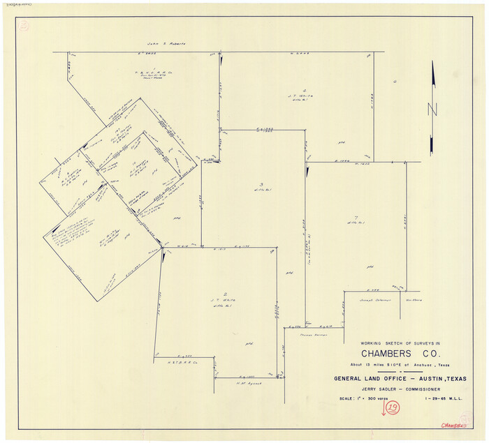
Chambers County Working Sketch 19
Print $20.00
- Digital $50.00
Chambers County Working Sketch 19
1965
Size 23.5 x 25.8 inches
Map/Doc 68002
Gillespie County Sketch File 16

Print $20.00
- Digital $50.00
Gillespie County Sketch File 16
1951
Size 18.2 x 17.9 inches
Map/Doc 11557
Val Verde County Working Sketch 117

Print $20.00
- Digital $50.00
Val Verde County Working Sketch 117
1993
Size 33.8 x 37.0 inches
Map/Doc 82842

Gaines County

Print $40.00
- Digital $50.00
Gaines County
1902
Size 38.9 x 49.7 inches
Map/Doc 66832
Red River County Sketch File 17a

Print $4.00
- Digital $50.00
Red River County Sketch File 17a
1853
Size 12.6 x 8.1 inches
Map/Doc 35145
Kerr County Rolled Sketch 4

Print $20.00
- Digital $50.00
Kerr County Rolled Sketch 4
Size 21.8 x 23.1 inches
Map/Doc 6493