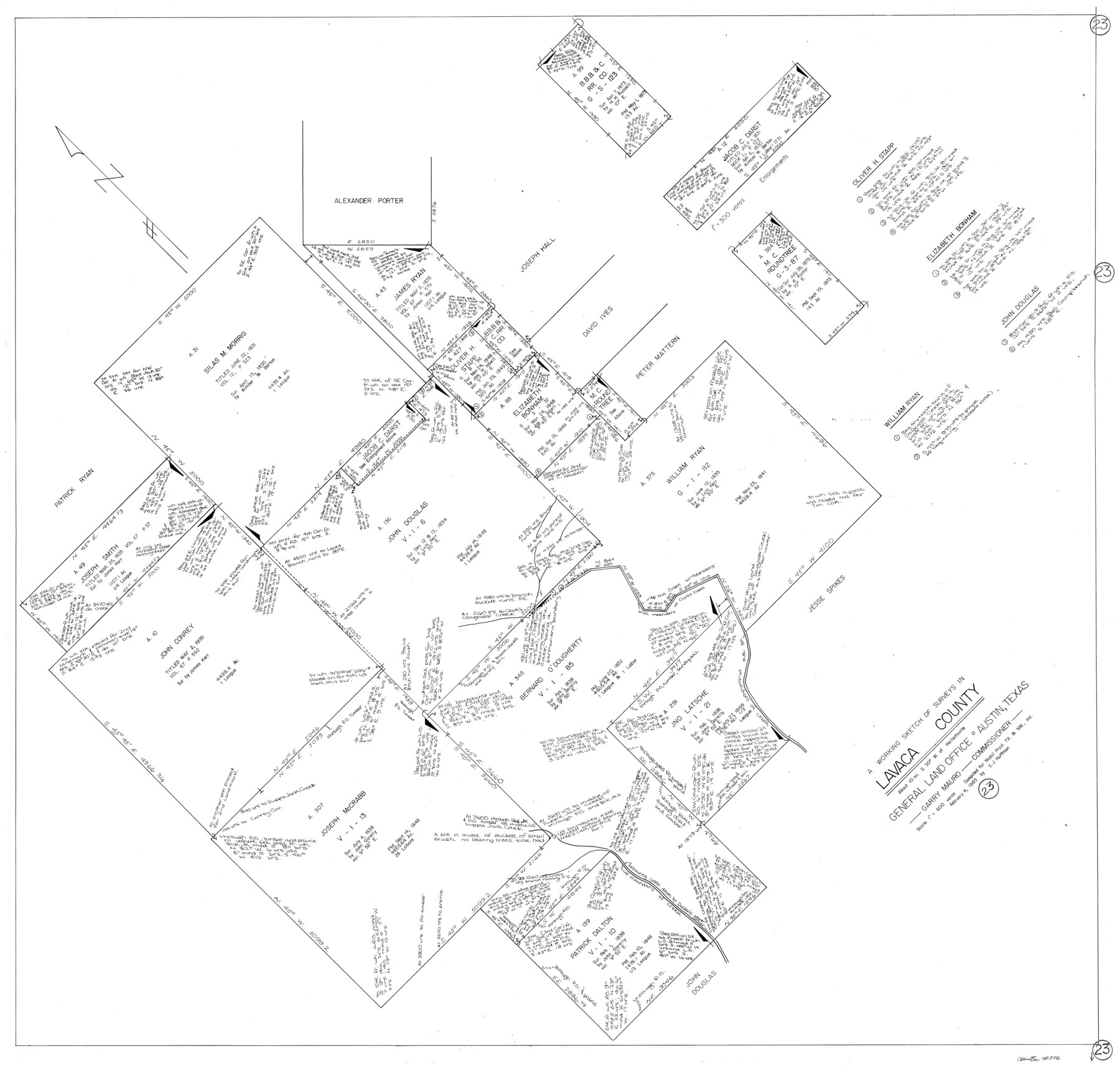
Lavaca County Working Sketch 23
-
Map/Doc
70376
-
Collection
General Map Collection
-
Object Dates
2/4/1985 (Creation Date)
-
People and Organizations
C.J. Huffman (Draftsman)
-
Counties
Lavaca
-
Subjects
Surveying Working Sketch
-
Height x Width
37.8 x 39.8 inches
96.0 x 101.1 cm
-
Scale
1" = 600 varas
Part of: General Map Collection
Webb County Rolled Sketch 41

Print $20.00
- Digital $50.00
Webb County Rolled Sketch 41
1941
Size 25.0 x 18.0 inches
Map/Doc 8196
Sabine County

Print $20.00
- Digital $50.00
Sabine County
1920
Size 41.2 x 31.8 inches
Map/Doc 77413
Sabine Bank to East Bay including Heald Bank

Print $20.00
- Digital $50.00
Sabine Bank to East Bay including Heald Bank
1957
Size 45.0 x 34.4 inches
Map/Doc 69846
United States - Gulf Coast - From Latitude 26° 33' to the Rio Grande Texas

Print $20.00
- Digital $50.00
United States - Gulf Coast - From Latitude 26° 33' to the Rio Grande Texas
1913
Size 27.9 x 18.2 inches
Map/Doc 72832
Zapata County Working Sketch 17

Print $20.00
- Digital $50.00
Zapata County Working Sketch 17
1970
Size 30.0 x 19.4 inches
Map/Doc 62068
Gaines County Rolled Sketch 12

Print $20.00
- Digital $50.00
Gaines County Rolled Sketch 12
1940
Size 26.4 x 33.5 inches
Map/Doc 5933
Cherokee County Sketch File 33

Print $16.00
- Digital $50.00
Cherokee County Sketch File 33
1935
Size 11.5 x 7.2 inches
Map/Doc 18190
Harrison County Rolled Sketch 14

Print $20.00
- Digital $50.00
Harrison County Rolled Sketch 14
1968
Size 25.8 x 20.0 inches
Map/Doc 6157
Houston County Rolled Sketch 12

Print $20.00
- Digital $50.00
Houston County Rolled Sketch 12
Size 11.8 x 18.1 inches
Map/Doc 95396
Parker County Working Sketch 26

Print $20.00
- Digital $50.00
Parker County Working Sketch 26
2008
Map/Doc 88856
Presidio County Sketch File 77

Print $20.00
- Digital $50.00
Presidio County Sketch File 77
Size 21.8 x 17.9 inches
Map/Doc 11721
Right of Way and Track Map, International & Gt. Northern Ry. Operated by the International & Gt. Northern Ry. Co., Gulf Division

Print $40.00
- Digital $50.00
Right of Way and Track Map, International & Gt. Northern Ry. Operated by the International & Gt. Northern Ry. Co., Gulf Division
1917
Size 25.0 x 56.6 inches
Map/Doc 64249
You may also like
Val Verde County Sketch File 18

Print $8.00
- Digital $50.00
Val Verde County Sketch File 18
1883
Size 13.1 x 8.4 inches
Map/Doc 39225
Gray County Working Sketch 5

Print $20.00
- Digital $50.00
Gray County Working Sketch 5
1959
Size 28.6 x 27.5 inches
Map/Doc 63236
Flight Mission No. CUG-3P, Frame 24, Kleberg County

Print $20.00
- Digital $50.00
Flight Mission No. CUG-3P, Frame 24, Kleberg County
1956
Size 18.4 x 22.3 inches
Map/Doc 86234
Trinity County Rolled Sketch 7

Print $20.00
- Digital $50.00
Trinity County Rolled Sketch 7
1999
Size 24.8 x 36.3 inches
Map/Doc 8054
Flight Mission No. CUG-1P, Frame 158, Kleberg County

Print $20.00
- Digital $50.00
Flight Mission No. CUG-1P, Frame 158, Kleberg County
1956
Size 18.5 x 22.3 inches
Map/Doc 86165
Outer Continental Shelf Leasing Maps (Louisiana Offshore Operations)

Print $20.00
- Digital $50.00
Outer Continental Shelf Leasing Maps (Louisiana Offshore Operations)
1955
Size 23.3 x 15.5 inches
Map/Doc 76094
Medina County

Print $40.00
- Digital $50.00
Medina County
1976
Size 53.5 x 44.2 inches
Map/Doc 95587
Culberson County Working Sketch 14

Print $20.00
- Digital $50.00
Culberson County Working Sketch 14
1923
Size 17.9 x 19.2 inches
Map/Doc 68466

[Northern Bexar District]
![1963, [Northern Bexar District], General Map Collection](https://historictexasmaps.com/wmedia_w700/maps/1963-1.tif.jpg)
Print $20.00
- Digital $50.00
[Northern Bexar District]
1852
Size 46.0 x 26.5 inches
Map/Doc 1963
Flight Mission No. CUG-3P, Frame 19, Kleberg County

Print $20.00
- Digital $50.00
Flight Mission No. CUG-3P, Frame 19, Kleberg County
1956
Size 18.7 x 22.3 inches
Map/Doc 86229
General Highway Map, Ochiltree County, Texas

Print $20.00
General Highway Map, Ochiltree County, Texas
1961
Size 18.2 x 24.3 inches
Map/Doc 79618