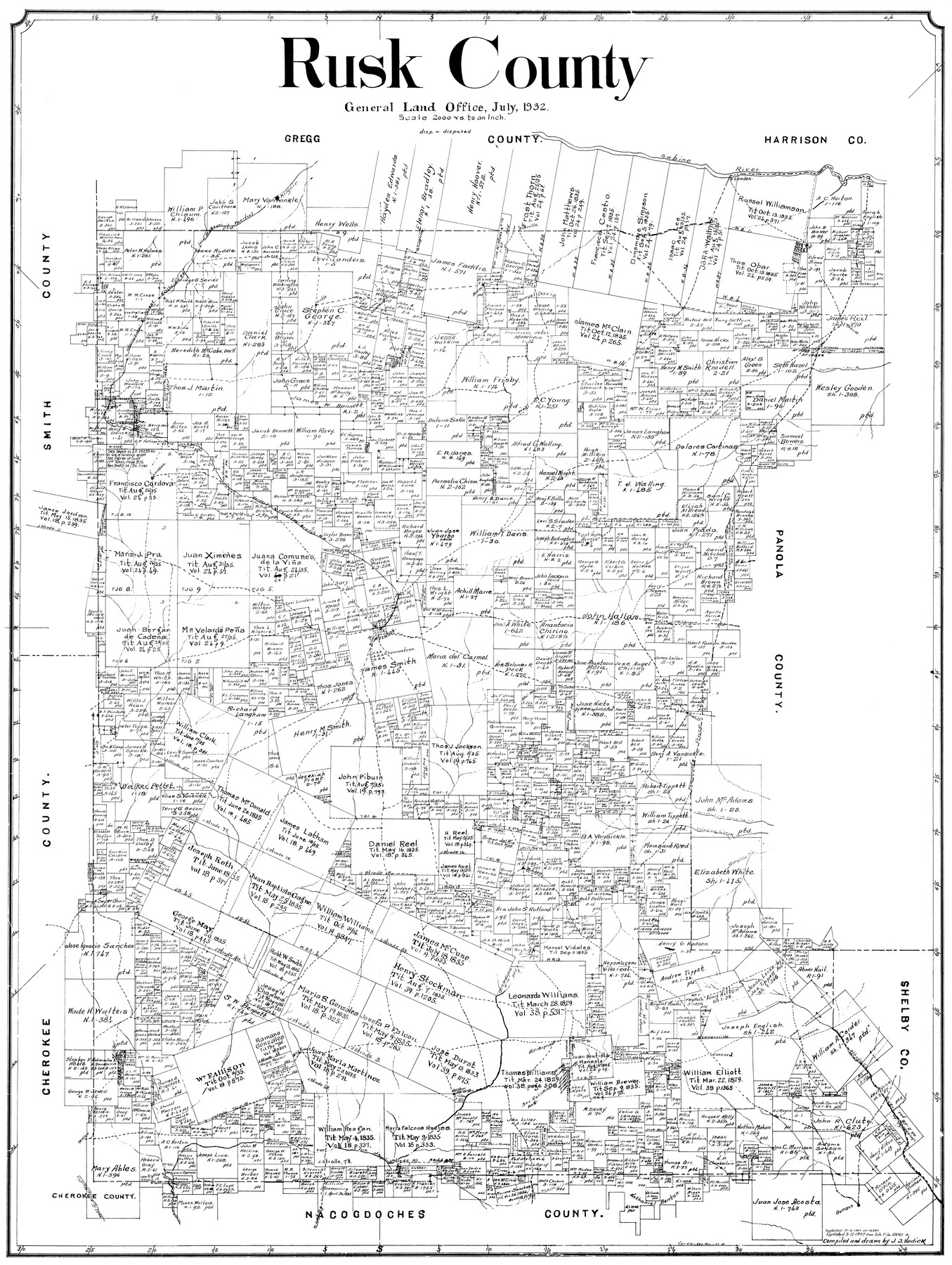
Rusk County
-
Map/Doc
77412
-
Collection
General Map Collection
-
Object Dates
7/1932 (Creation Date)
-
People and Organizations
John D. Hedick (Draftsman)
-
Counties
Rusk
-
Subjects
County
-
Height x Width
45.2 x 34.0 inches
114.8 x 86.4 cm
Part of: General Map Collection

[Galveston, Harrisburg & San Antonio through El Paso County]
![64005, [Galveston, Harrisburg & San Antonio through El Paso County], General Map Collection](https://historictexasmaps.com/wmedia_w700/maps/64005.tif.jpg)
Print $20.00
- Digital $50.00
[Galveston, Harrisburg & San Antonio through El Paso County]
1906
Size 13.3 x 33.6 inches
Map/Doc 64005
Map of Padre Island Showing Location of Zoning Districts

Print $20.00
- Digital $50.00
Map of Padre Island Showing Location of Zoning Districts
1971
Size 26.4 x 18.8 inches
Map/Doc 4813
Somervell County

Print $20.00
- Digital $50.00
Somervell County
1941
Size 29.2 x 27.1 inches
Map/Doc 95642
Webb County Rolled Sketch 38

Print $20.00
- Digital $50.00
Webb County Rolled Sketch 38
1940
Size 22.2 x 16.0 inches
Map/Doc 8193
Stephens County Sketch File 9a

Print $4.00
- Digital $50.00
Stephens County Sketch File 9a
1884
Size 8.6 x 8.2 inches
Map/Doc 37040
Crosby County Sketch File 12

Print $4.00
- Digital $50.00
Crosby County Sketch File 12
1895
Size 14.3 x 9.1 inches
Map/Doc 20034
Jackson County Rolled Sketch 5

Print $20.00
- Digital $50.00
Jackson County Rolled Sketch 5
1914
Size 22.3 x 20.2 inches
Map/Doc 6340
Intracoastal Waterway - Galveston Bay to West Bay including Galveston Bay Entrance

Print $20.00
- Digital $50.00
Intracoastal Waterway - Galveston Bay to West Bay including Galveston Bay Entrance
1961
Size 26.9 x 38.9 inches
Map/Doc 69935
Parker County Rolled Sketch 5

Print $20.00
- Digital $50.00
Parker County Rolled Sketch 5
1987
Size 21.9 x 21.4 inches
Map/Doc 7206
Cottle County Sketch File 6b

Print $2.00
- Digital $50.00
Cottle County Sketch File 6b
Size 8.8 x 14.1 inches
Map/Doc 19477
Chocolate Bay, West Portion of West Bay and Vicinity, Brazoria and Galveston Counties, showing Subdivision for Mineral Development

Print $40.00
- Digital $50.00
Chocolate Bay, West Portion of West Bay and Vicinity, Brazoria and Galveston Counties, showing Subdivision for Mineral Development
1948
Size 40.7 x 53.9 inches
Map/Doc 1907
You may also like
Duval County Sketch File 6c

Print $5.00
- Digital $50.00
Duval County Sketch File 6c
1875
Size 8.2 x 11.0 inches
Map/Doc 21292
[Northwest 1/4 of County]
![90824, [Northwest 1/4 of County], Twichell Survey Records](https://historictexasmaps.com/wmedia_w700/maps/90824-2.tif.jpg)
Print $20.00
- Digital $50.00
[Northwest 1/4 of County]
Size 19.1 x 23.3 inches
Map/Doc 90824
Butt's Map of Cooke County, Texas

Print $20.00
Butt's Map of Cooke County, Texas
1888
Size 17.5 x 14.5 inches
Map/Doc 88920
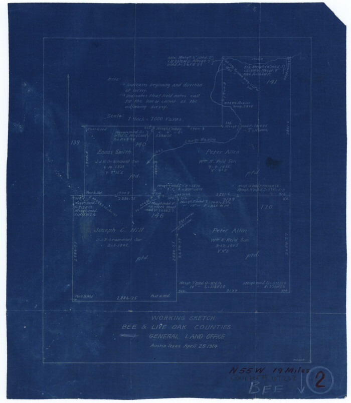
Bee County Working Sketch 2
Print $3.00
- Digital $50.00
Bee County Working Sketch 2
1914
Size 11.0 x 9.6 inches
Map/Doc 67252
Township No. 4 South Range No. 14 West of the Indian Meridian

Print $4.00
- Digital $50.00
Township No. 4 South Range No. 14 West of the Indian Meridian
1875
Size 18.0 x 22.4 inches
Map/Doc 75144
Flight Mission No. CGI-4N, Frame 177, Cameron County

Print $20.00
- Digital $50.00
Flight Mission No. CGI-4N, Frame 177, Cameron County
1955
Size 18.5 x 22.2 inches
Map/Doc 84680
Harris County Rolled Sketch P4

Print $20.00
- Digital $50.00
Harris County Rolled Sketch P4
1920
Size 12.1 x 34.6 inches
Map/Doc 6143
Copy of Surveyor's Field Book, Morris Browning - In Blocks 7, 5 & 4, I&GNRRCo., Hutchinson and Carson Counties, Texas

Print $2.00
- Digital $50.00
Copy of Surveyor's Field Book, Morris Browning - In Blocks 7, 5 & 4, I&GNRRCo., Hutchinson and Carson Counties, Texas
1888
Size 6.9 x 8.8 inches
Map/Doc 62264
Sketch showing connections made in survey of the Jerry Barton preemption

Print $20.00
- Digital $50.00
Sketch showing connections made in survey of the Jerry Barton preemption
1892
Size 18.7 x 23.6 inches
Map/Doc 75557
Hays County Rolled Sketch 23

Print $20.00
- Digital $50.00
Hays County Rolled Sketch 23
Size 20.1 x 19.4 inches
Map/Doc 6179
Working Sketch Cochran and Yoakum Co's.

Print $40.00
- Digital $50.00
Working Sketch Cochran and Yoakum Co's.
1919
Size 54.2 x 14.5 inches
Map/Doc 89678
Travis County Appraisal District Plat Map 2_0601

Print $20.00
- Digital $50.00
Travis County Appraisal District Plat Map 2_0601
Size 21.5 x 26.4 inches
Map/Doc 94235