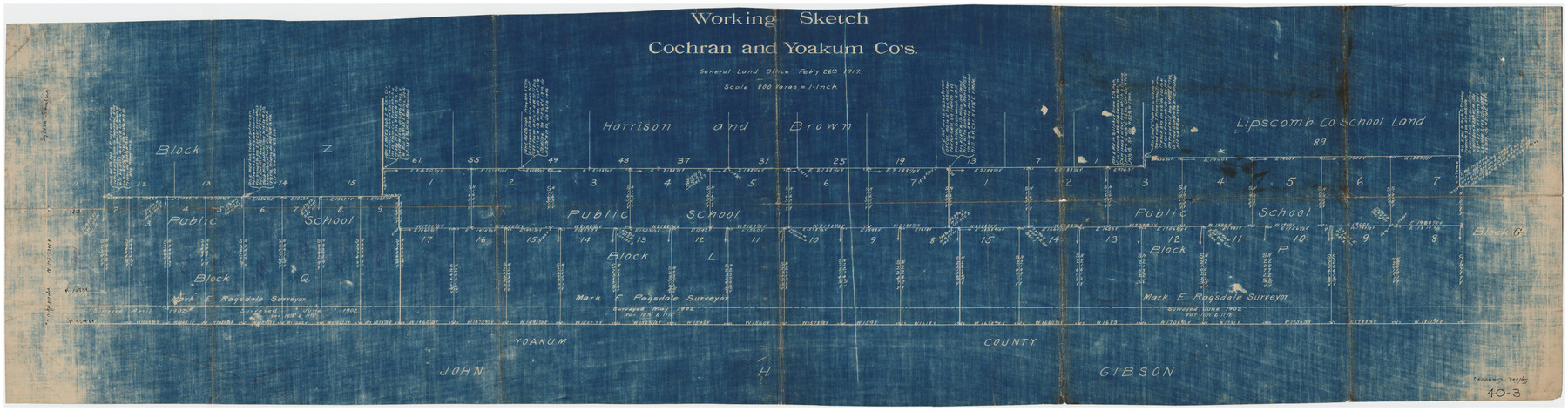
Working Sketch Cochran and Yoakum Co's.
40-3
-
Map/Doc
89678
-
Collection
Twichell Survey Records
-
Object Dates
2/26/1919 (Creation Date)
-
Counties
Cochran Yoakum
-
Height x Width
54.2 x 14.5 inches
137.7 x 36.8 cm
Part of: Twichell Survey Records
The T. B. Duggan Subdivision of League 125 and N 3/5 of League 126, Coke County School Lands, Cochran County, Texas

Print $20.00
- Digital $50.00
The T. B. Duggan Subdivision of League 125 and N 3/5 of League 126, Coke County School Lands, Cochran County, Texas
1920
Size 14.9 x 21.5 inches
Map/Doc 90300

Map of Adrian, the New Town in the Panhandle, Oldham County, Texas

Print $20.00
- Digital $50.00
Map of Adrian, the New Town in the Panhandle, Oldham County, Texas
Size 21.5 x 25.8 inches
Map/Doc 92135
Plat Showing Proposed Dam & Reservoir Under Application No. 561 Located at Mouth of Clear Fork of Brazos River

Print $20.00
- Digital $50.00
Plat Showing Proposed Dam & Reservoir Under Application No. 561 Located at Mouth of Clear Fork of Brazos River
1921
Size 24.0 x 16.6 inches
Map/Doc 92094
Section 148 Block G Abstract 1639 Cert. 57 Gaines County

Print $20.00
- Digital $50.00
Section 148 Block G Abstract 1639 Cert. 57 Gaines County
Size 13.0 x 13.7 inches
Map/Doc 93228
[Sketch showing Blocks 2B, 3B, 3T, IT and 2]
![91843, [Sketch showing Blocks 2B, 3B, 3T, IT and 2], Twichell Survey Records](https://historictexasmaps.com/wmedia_w700/maps/91843-1.tif.jpg)
Print $20.00
- Digital $50.00
[Sketch showing Blocks 2B, 3B, 3T, IT and 2]
1918
Size 32.9 x 30.1 inches
Map/Doc 91843
Map of C. W. Post's Land in Hockley County, Texas

Print $20.00
- Digital $50.00
Map of C. W. Post's Land in Hockley County, Texas
Size 24.7 x 15.7 inches
Map/Doc 91095
Subdivision Map of Fisher County School Land situated in Bailey and Cochran Counties, Texas

Print $20.00
- Digital $50.00
Subdivision Map of Fisher County School Land situated in Bailey and Cochran Counties, Texas
1924
Size 20.0 x 29.6 inches
Map/Doc 90243
[Sketch of surveys in the vicinity of sections 171 and 172 along Pedernales]
![91880, [Sketch of surveys in the vicinity of sections 171 and 172 along Pedernales], Twichell Survey Records](https://historictexasmaps.com/wmedia_w700/maps/91880-1.tif.jpg)
Print $20.00
- Digital $50.00
[Sketch of surveys in the vicinity of sections 171 and 172 along Pedernales]
Size 15.8 x 14.3 inches
Map/Doc 91880
[Blocks JD, B, D10, A2, A3]
![90777, [Blocks JD, B, D10, A2, A3], Twichell Survey Records](https://historictexasmaps.com/wmedia_w700/maps/90777-1.tif.jpg)
Print $2.00
- Digital $50.00
[Blocks JD, B, D10, A2, A3]
Size 7.3 x 13.4 inches
Map/Doc 90777
[Sketch showing various surveys south and along Holiday Creek]
![90164, [Sketch showing various surveys south and along Holiday Creek], Twichell Survey Records](https://historictexasmaps.com/wmedia_w700/maps/90164-1.tif.jpg)
Print $20.00
- Digital $50.00
[Sketch showing various surveys south and along Holiday Creek]
Size 40.6 x 35.1 inches
Map/Doc 90164
Block D14 Terry County

Print $20.00
- Digital $50.00
Block D14 Terry County
Size 17.0 x 17.7 inches
Map/Doc 92416
You may also like
Bird's Eye View of the City of Brenham, Washington County, Texas

Print $20.00
Bird's Eye View of the City of Brenham, Washington County, Texas
1881
Size 19.4 x 26.7 inches
Map/Doc 89076
Jackson County Sketch File 7

Print $24.00
- Digital $50.00
Jackson County Sketch File 7
1895
Size 14.2 x 8.7 inches
Map/Doc 27649
Concho County Working Sketch 5

Print $20.00
- Digital $50.00
Concho County Working Sketch 5
1948
Size 41.3 x 37.9 inches
Map/Doc 68187
Texas Land Commissioner George P. Bush's Energy Map of Texas Showing Significant Events and Well & Pipeline Locations Between 1543 and 2015

Print $20.00
- Digital $50.00
Texas Land Commissioner George P. Bush's Energy Map of Texas Showing Significant Events and Well & Pipeline Locations Between 1543 and 2015
2015
Size 33.3 x 36.3 inches
Map/Doc 93978
Menard County Working Sketch Graphic Index

Print $20.00
- Digital $50.00
Menard County Working Sketch Graphic Index
1942
Size 38.4 x 41.7 inches
Map/Doc 76640
Liberty County Sketch File 48

Print $6.00
- Digital $50.00
Liberty County Sketch File 48
1879
Size 12.2 x 8.3 inches
Map/Doc 30010
Pecos County Boundary File 1a

Print $12.00
- Digital $50.00
Pecos County Boundary File 1a
Size 12.6 x 8.3 inches
Map/Doc 57855
Chart of the West Indies and Spanish Dominions in North America

Print $20.00
- Digital $50.00
Chart of the West Indies and Spanish Dominions in North America
1803
Size 25.7 x 39.4 inches
Map/Doc 97137
Hudspeth County Rolled Sketch 51

Print $20.00
- Digital $50.00
Hudspeth County Rolled Sketch 51
1974
Size 19.2 x 25.7 inches
Map/Doc 6256
Terrell County Rolled Sketch 41

Print $20.00
- Digital $50.00
Terrell County Rolled Sketch 41
Size 18.6 x 34.3 inches
Map/Doc 9990
Bexar County Sketch File 41

Print $4.00
- Digital $50.00
Bexar County Sketch File 41
Size 8.3 x 5.3 inches
Map/Doc 14516
[Beaumont, Sour Lake and Western Ry. Right of Way and Alignment - Frisco]
![64133, [Beaumont, Sour Lake and Western Ry. Right of Way and Alignment - Frisco], General Map Collection](https://historictexasmaps.com/wmedia_w700/maps/64133.tif.jpg)
Print $20.00
- Digital $50.00
[Beaumont, Sour Lake and Western Ry. Right of Way and Alignment - Frisco]
1910
Size 20.0 x 45.5 inches
Map/Doc 64133