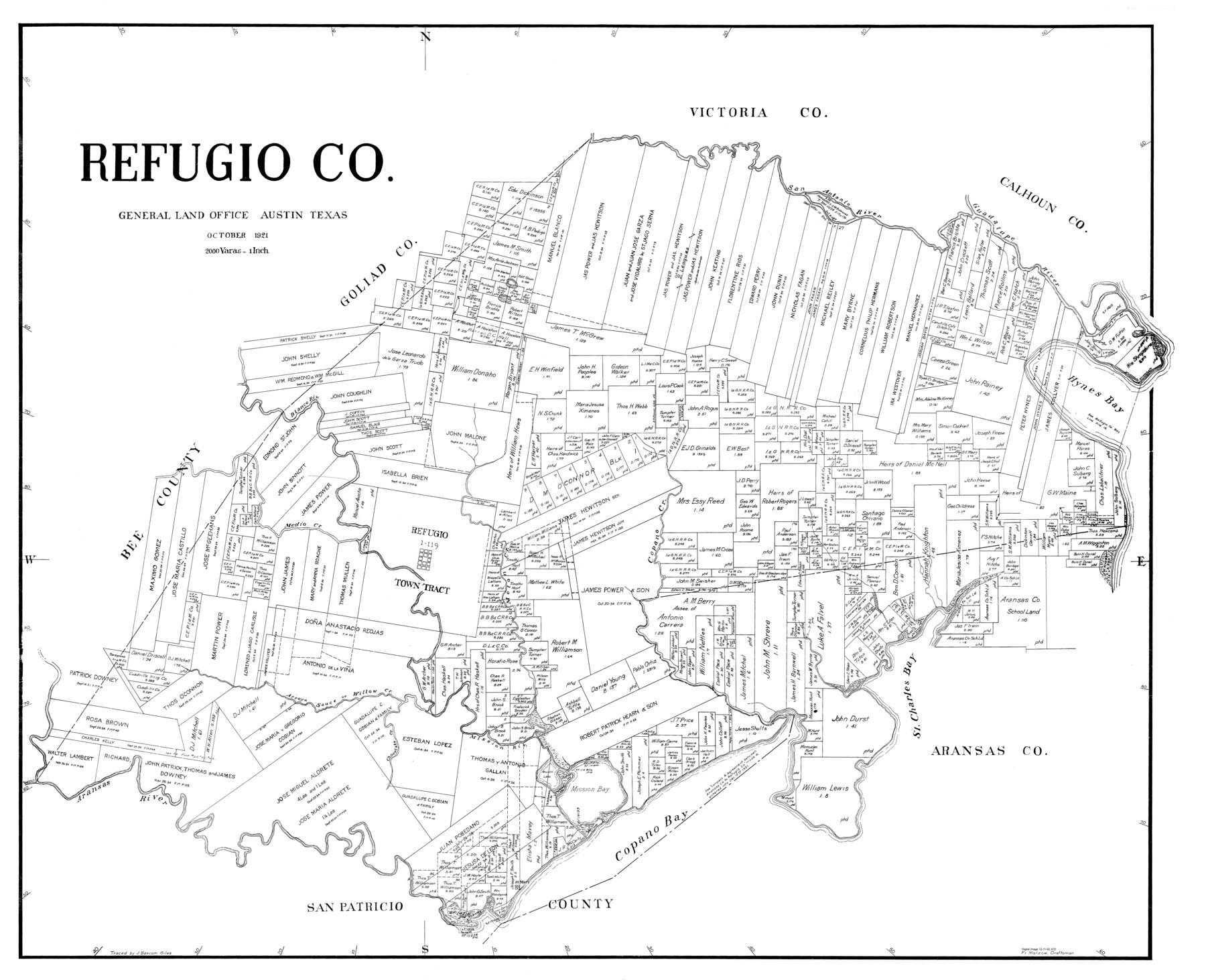
Refugio Co.
-
Map/Doc
77407
-
Collection
General Map Collection
-
Object Dates
1921 (Creation Date)
-
People and Organizations
Fr. Matzow (Draftsman)
-
Counties
Refugio
-
Subjects
County
-
Height x Width
39.1 x 48.1 inches
99.3 x 122.2 cm
Part of: General Map Collection
Flight Mission No. BRA-7M, Frame 33, Jefferson County

Print $20.00
- Digital $50.00
Flight Mission No. BRA-7M, Frame 33, Jefferson County
1953
Size 18.6 x 22.4 inches
Map/Doc 85484
Burnet County Sketch File 25

Print $4.00
- Digital $50.00
Burnet County Sketch File 25
1873
Size 8.1 x 8.6 inches
Map/Doc 16725
Flight Mission No. BQR-13K, Frame 27, Brazoria County

Print $20.00
- Digital $50.00
Flight Mission No. BQR-13K, Frame 27, Brazoria County
1952
Size 18.7 x 22.5 inches
Map/Doc 84075

Calhoun County Sketch File 16

Print $4.00
- Digital $50.00
Calhoun County Sketch File 16
1954
Size 10.7 x 8.3 inches
Map/Doc 35982
Flight Mission No. DAH-17M, Frame 68, Orange County

Print $20.00
- Digital $50.00
Flight Mission No. DAH-17M, Frame 68, Orange County
1953
Size 18.6 x 22.4 inches
Map/Doc 86902
Hudspeth County Working Sketch 31

Print $40.00
- Digital $50.00
Hudspeth County Working Sketch 31
1972
Size 56.2 x 41.2 inches
Map/Doc 66314
El Paso County Rolled Sketch 10

Print $93.00
- Digital $50.00
El Paso County Rolled Sketch 10
1883
Size 42.4 x 61.3 inches
Map/Doc 8853
Zavala County Working Sketch 29

Print $20.00
- Digital $50.00
Zavala County Working Sketch 29
1994
Size 33.1 x 42.9 inches
Map/Doc 62104
Hemphill County Working Sketch 11

Print $20.00
- Digital $50.00
Hemphill County Working Sketch 11
1965
Size 23.1 x 41.2 inches
Map/Doc 66106
Flight Mission No. BQY-4M, Frame 115, Harris County

Print $20.00
- Digital $50.00
Flight Mission No. BQY-4M, Frame 115, Harris County
1953
Size 18.6 x 22.5 inches
Map/Doc 85282
Edwards County Rolled Sketch 34

Print $20.00
- Digital $50.00
Edwards County Rolled Sketch 34
1994
Size 18.0 x 33.5 inches
Map/Doc 5816
You may also like
[Sections 59-70, I. & G. N. Block 1 and Runnels County School Land League 3]
![91680, [Sections 59-70, I. & G. N. Block 1 and Runnels County School Land League 3], Twichell Survey Records](https://historictexasmaps.com/wmedia_w700/maps/91680-1.tif.jpg)
Print $20.00
- Digital $50.00
[Sections 59-70, I. & G. N. Block 1 and Runnels County School Land League 3]
Size 22.7 x 20.4 inches
Map/Doc 91680
Flight Mission No. CRC-6R, Frame 41, Chambers County

Print $20.00
- Digital $50.00
Flight Mission No. CRC-6R, Frame 41, Chambers County
1956
Size 18.4 x 22.3 inches
Map/Doc 84974
Falls County Boundary File 1a

Print $56.00
- Digital $50.00
Falls County Boundary File 1a
1888
Size 14.6 x 9.2 inches
Map/Doc 53253
Atascosa County Sketch File 2a

Print $40.00
- Digital $50.00
Atascosa County Sketch File 2a
Size 25.1 x 15.3 inches
Map/Doc 10858
Angelina County Sketch File 17

Print $9.00
- Digital $50.00
Angelina County Sketch File 17
1863
Size 8.2 x 7.0 inches
Map/Doc 13020
Flight Mission No. DAG-21K, Frame 35, Matagorda County

Print $20.00
- Digital $50.00
Flight Mission No. DAG-21K, Frame 35, Matagorda County
1952
Size 18.6 x 22.4 inches
Map/Doc 86402
Montague County

Print $20.00
- Digital $50.00
Montague County
1924
Size 46.4 x 33.7 inches
Map/Doc 77376

Mitchell County Sketch File 16a

Print $12.00
- Digital $50.00
Mitchell County Sketch File 16a
1933
Size 11.3 x 8.8 inches
Map/Doc 31703
Throckmorton County Rolled Sketch 3C

Print $20.00
- Digital $50.00
Throckmorton County Rolled Sketch 3C
Size 31.1 x 37.1 inches
Map/Doc 7989
Map of N. W. Portion Blk G. Gaines Co.

Print $20.00
- Digital $50.00
Map of N. W. Portion Blk G. Gaines Co.
1914
Size 37.4 x 26.7 inches
Map/Doc 90867
Hamilton County Working Sketch 12

Print $20.00
- Digital $50.00
Hamilton County Working Sketch 12
1949
Size 43.9 x 41.7 inches
Map/Doc 63350