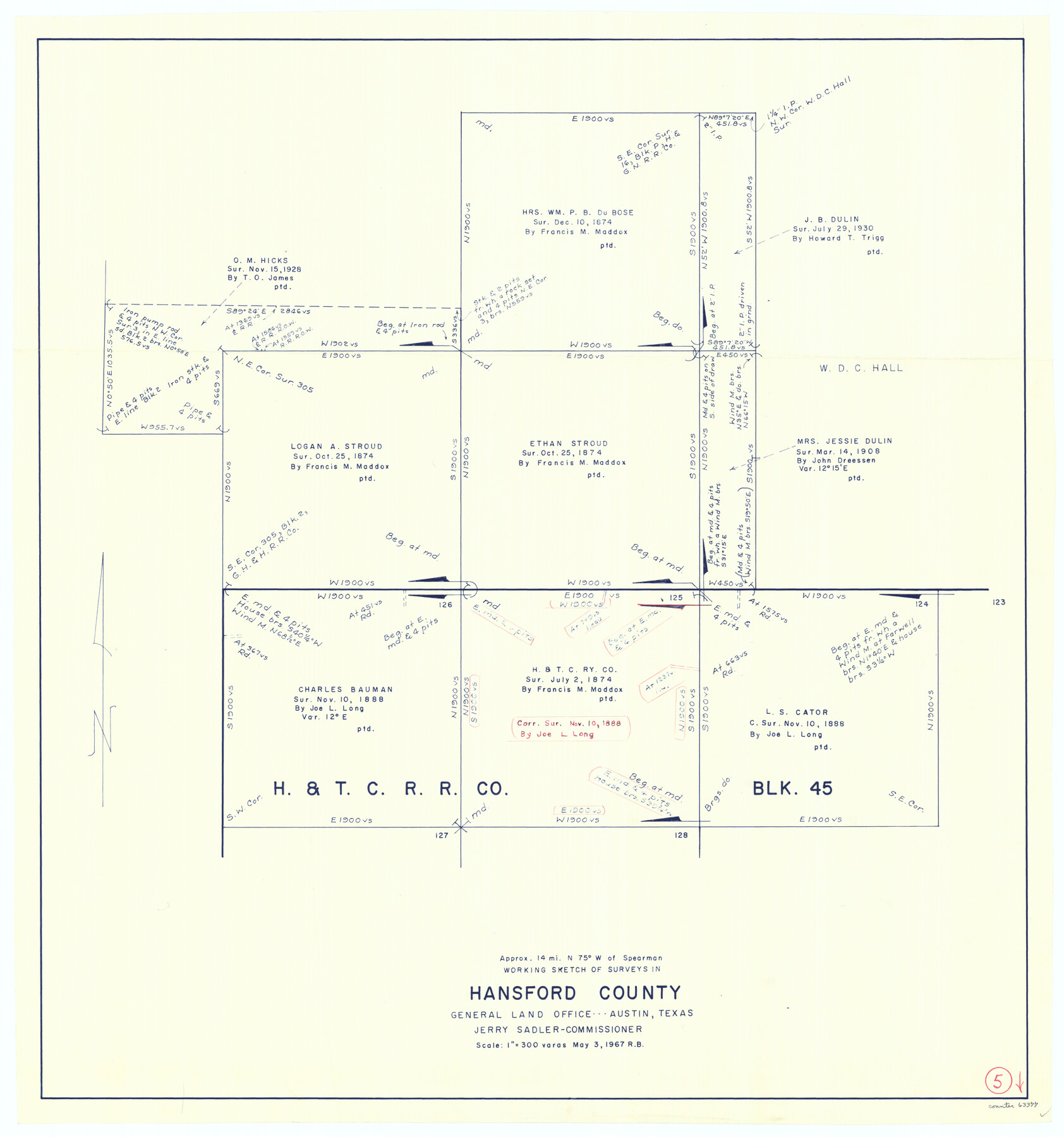
Hansford County Working Sketch 5
-
Map/Doc
63377
-
Collection
General Map Collection
-
Object Dates
5/3/1967 (Creation Date)
-
People and Organizations
Roy Buckholts (Draftsman)
-
Counties
Hansford
-
Subjects
Surveying Working Sketch
-
Height x Width
30.2 x 28.3 inches
76.7 x 71.9 cm
-
Scale
1" = 300 varas
Part of: General Map Collection
Map of Harris County

Print $20.00
- Digital $50.00
Map of Harris County
1893
Size 26.6 x 34.4 inches
Map/Doc 65810
Dickens County Sketch File J

Print $12.00
- Digital $50.00
Dickens County Sketch File J
1904
Size 11.6 x 9.1 inches
Map/Doc 20883
Galveston County NRC Article 33.136 Sketch 93

Digital $50.00
Galveston County NRC Article 33.136 Sketch 93
2020
Map/Doc 97257
Coast Chart No. 210 - Aransas Pass and Corpus Christi Bay with the coast to latitude 27° 12', Texas

Print $20.00
- Digital $50.00
Coast Chart No. 210 - Aransas Pass and Corpus Christi Bay with the coast to latitude 27° 12', Texas
1887
Size 23.4 x 29.4 inches
Map/Doc 73443
Pecos County Working Sketch 7

Print $20.00
- Digital $50.00
Pecos County Working Sketch 7
1892
Size 25.4 x 18.3 inches
Map/Doc 71477
Central United States [Verso]
![94195, Central United States [Verso], General Map Collection](https://historictexasmaps.com/wmedia_w700/maps/94195.tif.jpg)
Central United States [Verso]
1958
Size 18.5 x 38.7 inches
Map/Doc 94195
Jack County Working Sketch Graphic Index

Print $20.00
- Digital $50.00
Jack County Working Sketch Graphic Index
1925
Size 45.4 x 37.3 inches
Map/Doc 76589
Flight Mission No. BQY-4M, Frame 117, Harris County

Print $20.00
- Digital $50.00
Flight Mission No. BQY-4M, Frame 117, Harris County
1953
Size 18.5 x 22.3 inches
Map/Doc 85284
[Sketch for Mineral Application 26501 - Sabine River, T. A. Oldhausen]
![2834, [Sketch for Mineral Application 26501 - Sabine River, T. A. Oldhausen], General Map Collection](https://historictexasmaps.com/wmedia_w700/maps/2834.tif.jpg)
Print $20.00
- Digital $50.00
[Sketch for Mineral Application 26501 - Sabine River, T. A. Oldhausen]
1931
Size 23.9 x 36.0 inches
Map/Doc 2834
Concho County Sketch File 29

Print $12.00
- Digital $50.00
Concho County Sketch File 29
1886
Size 11.7 x 9.0 inches
Map/Doc 19169
Kaufman County Sketch File 5

Print $22.00
- Digital $50.00
Kaufman County Sketch File 5
1849
Size 7.6 x 12.6 inches
Map/Doc 28632
Brewster County Working Sketch 48

Print $20.00
- Digital $50.00
Brewster County Working Sketch 48
1949
Size 28.9 x 23.7 inches
Map/Doc 67582
You may also like
Midland County Rolled Sketch 2

Print $20.00
- Digital $50.00
Midland County Rolled Sketch 2
1949
Size 39.3 x 36.5 inches
Map/Doc 9513
Buffalo Bayou and the Houston Ship Channel 1820-1926

Buffalo Bayou and the Houston Ship Channel 1820-1926
1926
Size 6.2 x 9.1 inches
Map/Doc 97071
Comal County Sketch File 6

Print $6.00
- Digital $50.00
Comal County Sketch File 6
Size 10.3 x 8.1 inches
Map/Doc 19008
Old Miscellaneous File 7

Print $10.00
- Digital $50.00
Old Miscellaneous File 7
1848
Size 12.6 x 8.2 inches
Map/Doc 75422
Gregg County Boundary File 4

Print $14.00
- Digital $50.00
Gregg County Boundary File 4
Size 14.1 x 8.6 inches
Map/Doc 53992
Flight Mission No. DQN-6K, Frame 71, Calhoun County

Print $20.00
- Digital $50.00
Flight Mission No. DQN-6K, Frame 71, Calhoun County
1953
Size 18.5 x 22.2 inches
Map/Doc 84443
Midland County Sketch File 5

Print $2.00
- Digital $50.00
Midland County Sketch File 5
Size 8.4 x 3.5 inches
Map/Doc 31575
Flight Mission No. DAG-17K, Frame 140, Matagorda County

Print $20.00
- Digital $50.00
Flight Mission No. DAG-17K, Frame 140, Matagorda County
1952
Size 16.5 x 16.1 inches
Map/Doc 86357
Map of the country adjacent to the left bank of the Rio Grande below Matamoros

Print $20.00
- Digital $50.00
Map of the country adjacent to the left bank of the Rio Grande below Matamoros
1847
Size 18.3 x 28.2 inches
Map/Doc 72871
Wood County Sketch File 7

Print $17.00
- Digital $50.00
Wood County Sketch File 7
1848
Size 11.9 x 7.7 inches
Map/Doc 40645
Val Verde County Sketch File Z2

Print $31.00
- Digital $50.00
Val Verde County Sketch File Z2
1881
Size 16.7 x 10.7 inches
Map/Doc 39114
Jim Hogg County Working Sketch 2

Print $20.00
- Digital $50.00
Jim Hogg County Working Sketch 2
1933
Size 41.2 x 29.3 inches
Map/Doc 66588