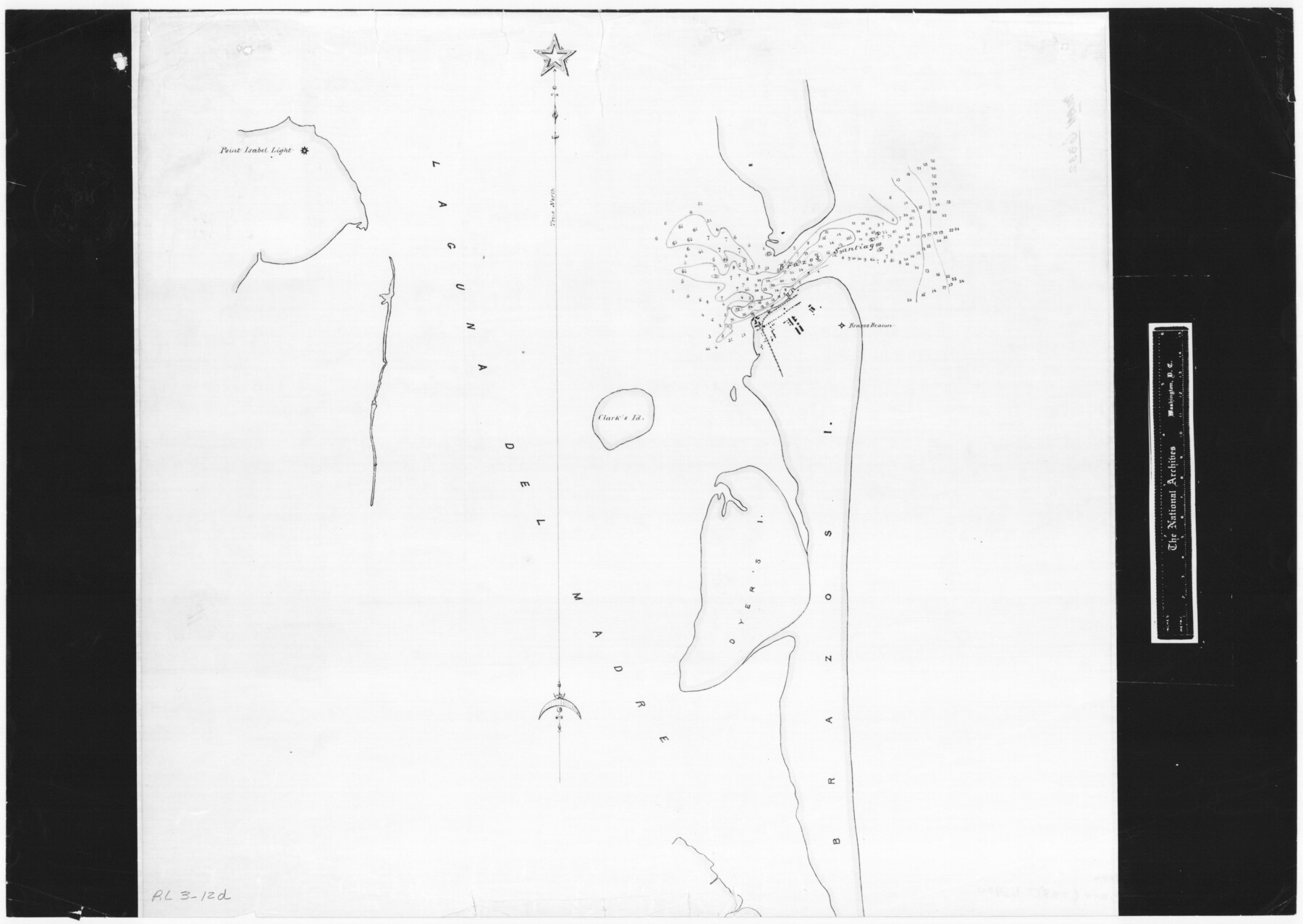
Brazos Santiago & Boca Chica entrances, Texas
RL-3-12d
-
Map/Doc
72928
-
Collection
General Map Collection
-
Object Dates
1867 (Creation Date)
-
People and Organizations
U. S. Coast Survey Office (Author)
-
Subjects
Nautical Charts
-
Height x Width
18.3 x 25.7 inches
46.5 x 65.3 cm
-
Comments
B/W photostat copy from National Archives in multiple pieces.
Part of: General Map Collection
Gillespie County Sketch File 16

Print $20.00
- Digital $50.00
Gillespie County Sketch File 16
1951
Size 18.2 x 17.9 inches
Map/Doc 11557
Flight Mission No. BRA-16M, Frame 88, Jefferson County

Print $20.00
- Digital $50.00
Flight Mission No. BRA-16M, Frame 88, Jefferson County
1953
Size 18.5 x 22.3 inches
Map/Doc 85700
Montgomery County Boundary File 3

Print $6.00
- Digital $50.00
Montgomery County Boundary File 3
Size 17.0 x 9.9 inches
Map/Doc 57450
Andrews County

Print $40.00
- Digital $50.00
Andrews County
1901
Size 35.9 x 49.7 inches
Map/Doc 4872
Anderson County Sketch File 25

Print $40.00
- Digital $50.00
Anderson County Sketch File 25
1969
Size 40.9 x 21.9 inches
Map/Doc 10316
Pecos County Rolled Sketch 93

Print $40.00
- Digital $50.00
Pecos County Rolled Sketch 93
Size 50.3 x 42.8 inches
Map/Doc 9711
San Jacinto County Rolled Sketch 14

Print $20.00
- Digital $50.00
San Jacinto County Rolled Sketch 14
1998
Size 28.1 x 40.0 inches
Map/Doc 7564
Marion County Working Sketch 29

Print $20.00
- Digital $50.00
Marion County Working Sketch 29
1977
Size 20.4 x 16.1 inches
Map/Doc 70805
Nueces County Rolled Sketch 39

Print $20.00
- Digital $50.00
Nueces County Rolled Sketch 39
1957
Size 32.9 x 45.3 inches
Map/Doc 6879
Pecos County Rolled Sketch 47

Print $20.00
- Digital $50.00
Pecos County Rolled Sketch 47
1913
Size 20.3 x 43.8 inches
Map/Doc 7225
[Sketch for Mineral Application 26501 - Sabine River, T. A. Oldhausen]
![2835, [Sketch for Mineral Application 26501 - Sabine River, T. A. Oldhausen], General Map Collection](https://historictexasmaps.com/wmedia_w700/maps/2835.tif.jpg)
Print $20.00
- Digital $50.00
[Sketch for Mineral Application 26501 - Sabine River, T. A. Oldhausen]
1931
Size 24.6 x 36.6 inches
Map/Doc 2835
Burnet County Rolled Sketch 7

Print $20.00
- Digital $50.00
Burnet County Rolled Sketch 7
1987
Size 18.4 x 24.0 inches
Map/Doc 5357
You may also like
Denton County Working Sketch 34

Print $20.00
- Digital $50.00
Denton County Working Sketch 34
2005
Size 22.2 x 27.3 inches
Map/Doc 83570
Henderson County Rolled Sketch 11

Print $20.00
- Digital $50.00
Henderson County Rolled Sketch 11
1915
Size 29.2 x 41.6 inches
Map/Doc 76147
Starr County Rolled Sketch 25

Print $20.00
- Digital $50.00
Starr County Rolled Sketch 25
1939
Size 28.0 x 38.5 inches
Map/Doc 7809
[H. & T. C. Block 47]
![91834, [H. & T. C. Block 47], Twichell Survey Records](https://historictexasmaps.com/wmedia_w700/maps/91834-1.tif.jpg)
Print $20.00
- Digital $50.00
[H. & T. C. Block 47]
Size 19.4 x 18.5 inches
Map/Doc 91834
Map showing the environs of Brazos Islnd. Texas

Print $20.00
- Digital $50.00
Map showing the environs of Brazos Islnd. Texas
1864
Size 26.2 x 18.2 inches
Map/Doc 72914
University Land Field Notes for Blocks A, B, C, D, E, F, G, H, I, and J in Hudspeth County

University Land Field Notes for Blocks A, B, C, D, E, F, G, H, I, and J in Hudspeth County
Map/Doc 81712
Johnson's Texas

Print $20.00
- Digital $50.00
Johnson's Texas
1866
Size 18.4 x 27.2 inches
Map/Doc 89279
Map of Location of the Pecos & Northern Texas Railway from Station 5868+52 to Station 7879+36 = 38.08 Miles through Parmer County, Texas

Print $40.00
- Digital $50.00
Map of Location of the Pecos & Northern Texas Railway from Station 5868+52 to Station 7879+36 = 38.08 Miles through Parmer County, Texas
Size 20.2 x 108.5 inches
Map/Doc 64090
Coryell County Milam District

Print $20.00
- Digital $50.00
Coryell County Milam District
1883
Size 25.7 x 24.6 inches
Map/Doc 3446

Map of the Location Survey of the Hearne & Brazos Valley Railroad

Print $40.00
- Digital $50.00
Map of the Location Survey of the Hearne & Brazos Valley Railroad
1891
Size 40.7 x 122.9 inches
Map/Doc 64347
[University Lands]
![62966, [University Lands], General Map Collection](https://historictexasmaps.com/wmedia_w700/maps/62966.tif.jpg)
Print $40.00
- Digital $50.00
[University Lands]
1885
Size 52.9 x 39.5 inches
Map/Doc 62966