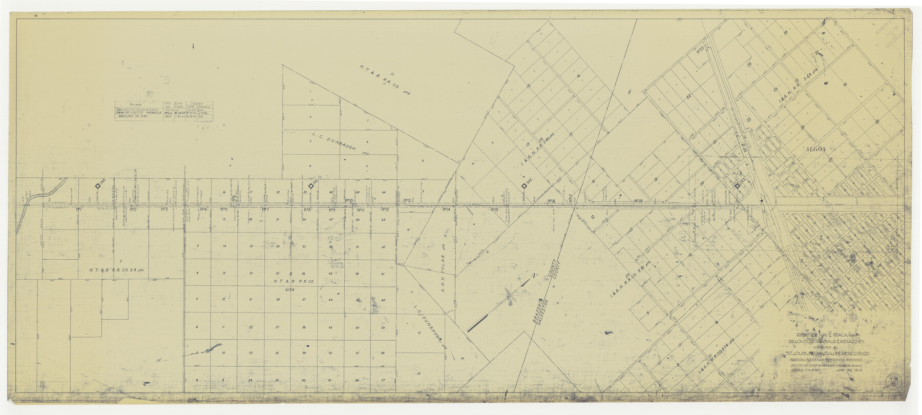
Right of Way & Track Map, St. Louis, Brownsville & Mexico Ry. operated by St. Louis, Brownsville & Mexico Ry. Co.
Station 17938+43 to Station 18150+00
Z-2-183
-
Map/Doc
64625
-
Collection
General Map Collection
-
Object Dates
1919/6/30 (Creation Date)
-
Counties
Brazoria Galveston
-
Subjects
Railroads
-
Height x Width
25.7 x 57.1 inches
65.3 x 145.0 cm
-
Medium
blueprint/diazo
-
Scale
1" = 400 feet
-
Comments
Jefferson Lake Oil Company.
See counter nos. 64612 through 64624 and 64626 for other sheets. -
Features
SLB&M
New Algoa
Algoa
[Railroad line] to Brownsville
Mustang Bayou
Part of: General Map Collection
Pecos County Working Sketch 44

Print $20.00
- Digital $50.00
Pecos County Working Sketch 44
1945
Size 29.6 x 35.0 inches
Map/Doc 71516
San Patricio County Sketch File 50

Print $8.00
- Digital $50.00
San Patricio County Sketch File 50
1873
Size 14.4 x 8.8 inches
Map/Doc 36371

Stephens County Boundary File 3

Print $25.00
- Digital $50.00
Stephens County Boundary File 3
Size 14.2 x 8.8 inches
Map/Doc 58882
Houston County Sketch File 6a

Print $4.00
- Digital $50.00
Houston County Sketch File 6a
Size 10.2 x 8.1 inches
Map/Doc 26762
Flight Mission No. BRA-16M, Frame 72, Jefferson County

Print $20.00
- Digital $50.00
Flight Mission No. BRA-16M, Frame 72, Jefferson County
1953
Size 18.5 x 22.4 inches
Map/Doc 85689
Jeff Davis Co.

Print $40.00
- Digital $50.00
Jeff Davis Co.
1915
Size 26.7 x 49.4 inches
Map/Doc 3720


Flight Mission No. BRA-16M, Frame 150, Jefferson County

Print $20.00
- Digital $50.00
Flight Mission No. BRA-16M, Frame 150, Jefferson County
1953
Size 18.5 x 22.3 inches
Map/Doc 85756
Pecos County Working Sketch 66

Print $20.00
- Digital $50.00
Pecos County Working Sketch 66
1955
Size 25.8 x 21.2 inches
Map/Doc 71538
Cottle County Sketch File 7 1/2

Print $26.00
- Digital $50.00
Cottle County Sketch File 7 1/2
1889
Size 40.2 x 21.0 inches
Map/Doc 10342
You may also like
Burnet County

Print $20.00
- Digital $50.00
Burnet County
1881
Size 16.0 x 16.2 inches
Map/Doc 75785
Austin County Working Sketch 1

Print $20.00
- Digital $50.00
Austin County Working Sketch 1
1941
Size 27.7 x 30.1 inches
Map/Doc 67242
Outer Continental Shelf Leasing Maps (Louisiana Offshore Operations)

Print $20.00
- Digital $50.00
Outer Continental Shelf Leasing Maps (Louisiana Offshore Operations)
1954
Size 18.2 x 16.0 inches
Map/Doc 76105
Crosby County Rolled Sketch 2

Print $20.00
- Digital $50.00
Crosby County Rolled Sketch 2
1980
Size 24.7 x 18.7 inches
Map/Doc 5642
Map of Swisher Addition

Print $20.00
- Digital $50.00
Map of Swisher Addition
1910
Size 18.0 x 13.1 inches
Map/Doc 83425
Leon County Rolled Sketch 2

Print $20.00
- Digital $50.00
Leon County Rolled Sketch 2
Size 30.7 x 34.6 inches
Map/Doc 6606

Coast Chart No. 105 - Galveston Bay to Oyster Bay, Texas

Print $20.00
- Digital $50.00
Coast Chart No. 105 - Galveston Bay to Oyster Bay, Texas
1884
Size 24.1 x 29.6 inches
Map/Doc 69926
General Highway Map, Caldwell County, Texas

Print $20.00
General Highway Map, Caldwell County, Texas
1961
Size 18.3 x 24.6 inches
Map/Doc 79394
Reeves County Working Sketch 29

Print $20.00
- Digital $50.00
Reeves County Working Sketch 29
1969
Size 20.1 x 41.5 inches
Map/Doc 63472
Brewster County Rolled Sketch 52

Print $20.00
- Digital $50.00
Brewster County Rolled Sketch 52
1930
Size 15.3 x 41.4 inches
Map/Doc 61782
Shackelford County Rolled Sketch 3

Print $40.00
- Digital $50.00
Shackelford County Rolled Sketch 3
1955
Size 35.4 x 49.9 inches
Map/Doc 9915