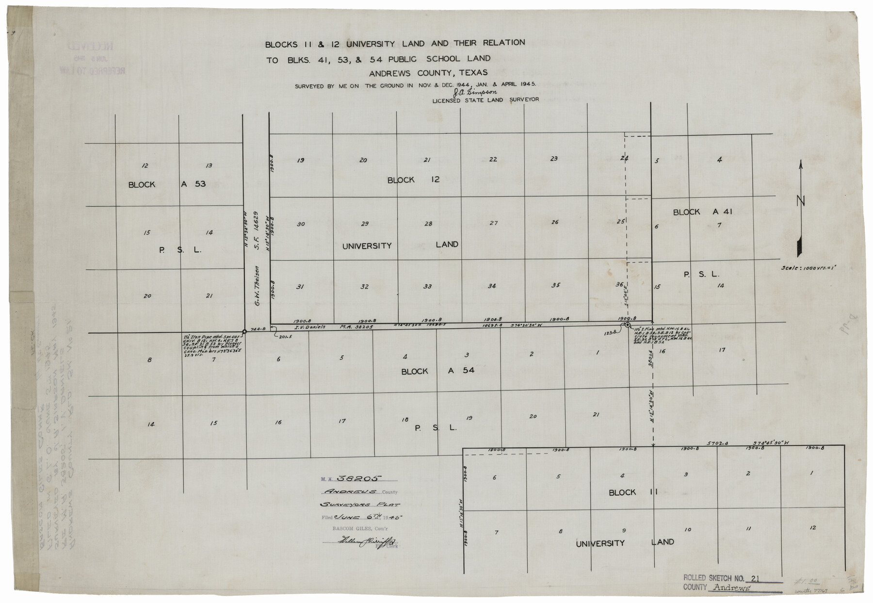
Andrews County Rolled Sketch 21
Blocks 11 & 12 University Land and their relation to Blks. 41, 53, & 54 Public School Land
-
Map/Doc
77169
-
Collection
General Map Collection
-
Object Dates
1945 (Survey Date)
1945/6/6 (File Date)
1944 (Survey Date)
1944 (Survey Date)
1945 (Survey Date)
-
People and Organizations
J.A. Simpson (Surveyor/Engineer)
-
Counties
Andrews
-
Subjects
Surveying Rolled Sketch
-
Height x Width
18.2 x 26.3 inches
46.2 x 66.8 cm
-
Medium
linen, manuscript
-
Scale
1" = 1000 varas
-
Comments
Surveyed in November and December 1944 and January and April 1945.
Part of: General Map Collection

Bandera County Sketch File 30

Print $40.00
- Digital $50.00
Bandera County Sketch File 30
Size 16.8 x 13.4 inches
Map/Doc 14021
Crockett County Rolled Sketch 55

Print $40.00
- Digital $50.00
Crockett County Rolled Sketch 55
Size 42.3 x 95.8 inches
Map/Doc 8718
Gregg County Rolled Sketch FB

Print $84.00
- Digital $50.00
Gregg County Rolled Sketch FB
1932
Size 25.2 x 56.7 inches
Map/Doc 9326
Fort Bend County Rolled Sketch 7

Print $20.00
- Digital $50.00
Fort Bend County Rolled Sketch 7
1919
Size 21.1 x 24.0 inches
Map/Doc 5898
Motley County Sketch File B4 (N)

Print $20.00
- Digital $50.00
Motley County Sketch File B4 (N)
1900
Size 23.5 x 25.8 inches
Map/Doc 42151
[The S.K. Ry. of Texas, State Line to Pecos, Reeves Co., Texas]
![64160, [The S.K. Ry. of Texas, State Line to Pecos, Reeves Co., Texas], General Map Collection](https://historictexasmaps.com/wmedia_w700/maps/64160.tif.jpg)
Print $40.00
- Digital $50.00
[The S.K. Ry. of Texas, State Line to Pecos, Reeves Co., Texas]
1910
Size 19.5 x 119.7 inches
Map/Doc 64160
Crockett County Sketch File 85

Print $6.00
- Digital $50.00
Crockett County Sketch File 85
1952
Size 33.7 x 31.2 inches
Map/Doc 10345
Cottle County Working Sketch 21

Print $20.00
- Digital $50.00
Cottle County Working Sketch 21
1982
Size 37.0 x 46.6 inches
Map/Doc 68331
Taylor County Sketch File 23

Print $19.00
- Digital $50.00
Taylor County Sketch File 23
2005
Size 11.0 x 8.5 inches
Map/Doc 87114
Schleicher County Working Sketch 17

Print $20.00
- Digital $50.00
Schleicher County Working Sketch 17
1946
Size 21.8 x 23.1 inches
Map/Doc 63819
Brewster County Rolled Sketch 125

Print $179.00
- Digital $50.00
Brewster County Rolled Sketch 125
1889
Map/Doc 43141
You may also like
Gillespie County Sketch File 4a

Print $40.00
- Digital $50.00
Gillespie County Sketch File 4a
Size 15.8 x 12.8 inches
Map/Doc 24137
[Block 35, Townships 3N, 4N, and 5N]
![90640, [Block 35, Townships 3N, 4N, and 5N], Twichell Survey Records](https://historictexasmaps.com/wmedia_w700/maps/90640-1.tif.jpg)
Print $40.00
- Digital $50.00
[Block 35, Townships 3N, 4N, and 5N]
Size 15.6 x 48.1 inches
Map/Doc 90640
Kimble County Sketch File 5

Print $4.00
- Digital $50.00
Kimble County Sketch File 5
1858
Size 7.9 x 5.5 inches
Map/Doc 28916
Trinity County Sketch File 28

Print $22.00
- Digital $50.00
Trinity County Sketch File 28
Size 7.0 x 19.7 inches
Map/Doc 38564
[Section 35 1/2, Block C-41]
![92967, [Section 35 1/2, Block C-41], Twichell Survey Records](https://historictexasmaps.com/wmedia_w700/maps/92967-1.tif.jpg)
Print $20.00
- Digital $50.00
[Section 35 1/2, Block C-41]
1951
Size 23.9 x 9.2 inches
Map/Doc 92967
Map of Texas, compiled from surveys on record in the General Land Office of the Republic

Print $20.00
- Digital $50.00
Map of Texas, compiled from surveys on record in the General Land Office of the Republic
1839
Size 33.0 x 25.3 inches
Map/Doc 93858
Flight Mission No. DCL-6C, Frame 77, Kenedy County

Print $20.00
- Digital $50.00
Flight Mission No. DCL-6C, Frame 77, Kenedy County
1943
Size 18.5 x 22.3 inches
Map/Doc 85919
Plan of the City of Galveston, Texas

Print $20.00
- Digital $50.00
Plan of the City of Galveston, Texas
1845
Size 18.4 x 27.8 inches
Map/Doc 62970
General Highway Map, Nueces County, Texas

Print $20.00
General Highway Map, Nueces County, Texas
1940
Size 24.6 x 18.5 inches
Map/Doc 79209
Howard County Boundary File 2a

Print $9.00
- Digital $50.00
Howard County Boundary File 2a
Size 14.6 x 11.3 inches
Map/Doc 55118
Flight Mission No. CGI-1N, Frame 177, Cameron County

Print $20.00
- Digital $50.00
Flight Mission No. CGI-1N, Frame 177, Cameron County
1955
Size 18.5 x 17.6 inches
Map/Doc 84512
Taylor County Rolled Sketch 21

Print $20.00
- Digital $50.00
Taylor County Rolled Sketch 21
Size 31.5 x 40.5 inches
Map/Doc 9985