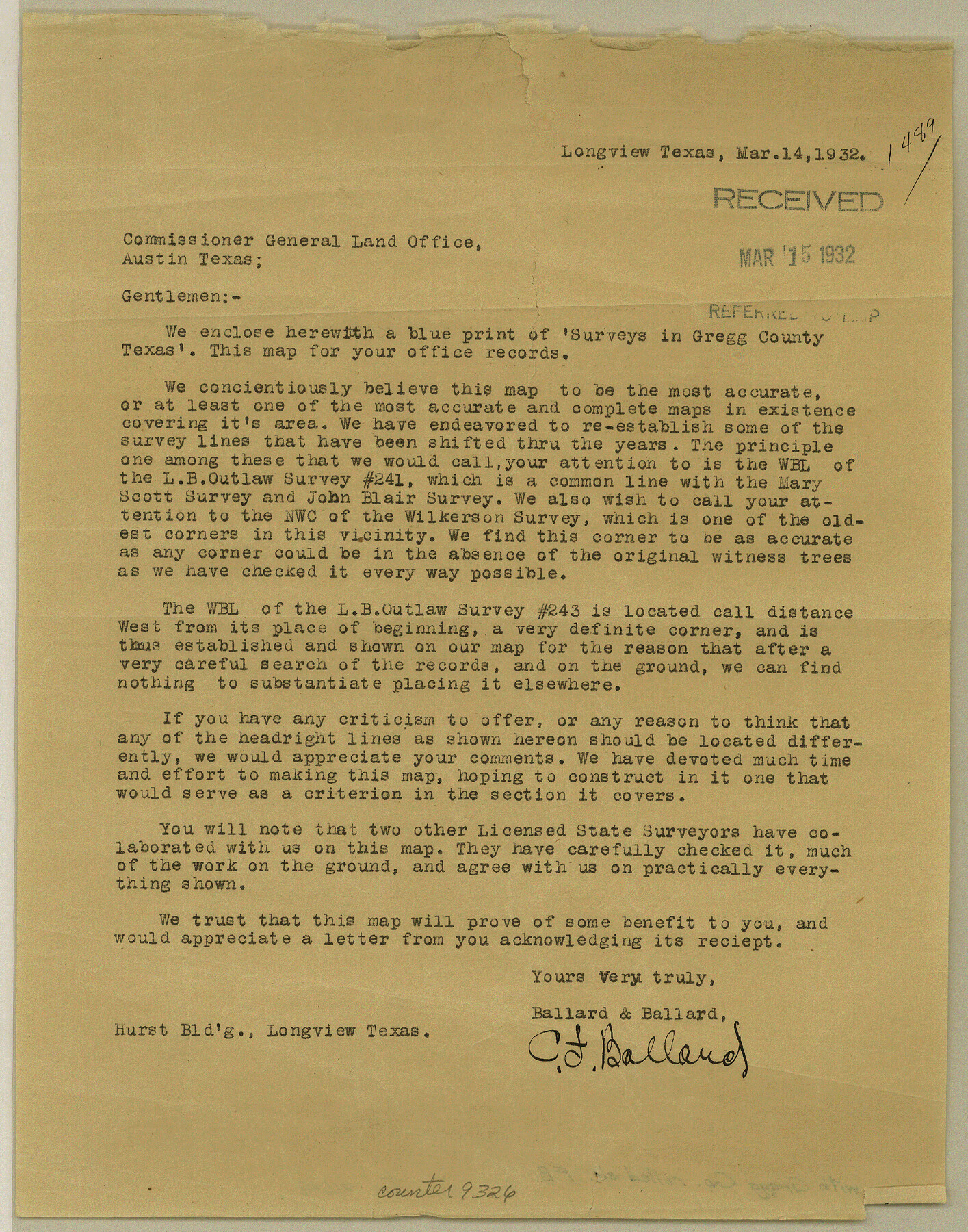
Gregg County Rolled Sketch FB
[Sketch and statement of area around L.B. Outlaw survey no. 243]
-
Map/Doc
9326
-
Collection
General Map Collection
-
Object Dates
1932/3/15 (File Date)
1932/3/14 (Creation Date)
-
People and Organizations
George F. Ballard (Surveyor/Engineer)
C.F. Ballard (Surveyor/Engineer)
-
Counties
Gregg
-
Subjects
Surveying Rolled Sketch
-
Height x Width
25.2 x 56.7 inches
64.0 x 144.0 cm
-
Medium
multi-page, multi-format
Part of: General Map Collection
Liberty County Sketch File 25

Print $8.00
- Digital $50.00
Liberty County Sketch File 25
1861
Size 8.0 x 10.0 inches
Map/Doc 29939
Hudspeth County Working Sketch 43

Print $40.00
- Digital $50.00
Hudspeth County Working Sketch 43
1981
Size 37.4 x 53.7 inches
Map/Doc 66328
Galveston County Sketch File 1

Print $4.00
- Digital $50.00
Galveston County Sketch File 1
Size 12.7 x 8.5 inches
Map/Doc 23346
Harris County Historic Topographic 18

Print $20.00
- Digital $50.00
Harris County Historic Topographic 18
1916
Size 29.4 x 23.0 inches
Map/Doc 65828
[Plat of All Surveys on Lavaca Not Heretofor Returned]
![283, [Plat of All Surveys on Lavaca Not Heretofor Returned], General Map Collection](https://historictexasmaps.com/wmedia_w700/maps/283.tif.jpg)
Print $20.00
- Digital $50.00
[Plat of All Surveys on Lavaca Not Heretofor Returned]
1841
Size 31.3 x 22.0 inches
Map/Doc 283
Hansford County Working Sketch 1

Print $40.00
- Digital $50.00
Hansford County Working Sketch 1
1934
Size 43.0 x 54.1 inches
Map/Doc 63373
Nueces County Sketch File 59

Print $23.00
- Digital $50.00
Nueces County Sketch File 59
1989
Size 11.2 x 8.6 inches
Map/Doc 32951
Coleman County Sketch File 45

Print $20.00
- Digital $50.00
Coleman County Sketch File 45
1897
Size 23.9 x 23.8 inches
Map/Doc 11124
Van Zandt County Working Sketch Graphic Index

Print $20.00
- Digital $50.00
Van Zandt County Working Sketch Graphic Index
1972
Size 46.2 x 40.7 inches
Map/Doc 76727
Nueces County Rolled Sketch 40

Print $101.00
- Digital $50.00
Nueces County Rolled Sketch 40
1962
Size 10.3 x 15.3 inches
Map/Doc 47850
Childress County Rolled Sketch 8A

Print $20.00
- Digital $50.00
Childress County Rolled Sketch 8A
Size 18.2 x 12.9 inches
Map/Doc 5443
Dickens County Sketch File L

Print $22.00
- Digital $50.00
Dickens County Sketch File L
1909
Size 7.7 x 9.0 inches
Map/Doc 20892
You may also like
Flight Mission No. CGI-1N, Frame 180, Cameron County

Print $20.00
- Digital $50.00
Flight Mission No. CGI-1N, Frame 180, Cameron County
1955
Size 18.5 x 22.2 inches
Map/Doc 84515
Aransas County Rolled Sketch 24

Print $20.00
- Digital $50.00
Aransas County Rolled Sketch 24
Size 22.5 x 34.8 inches
Map/Doc 77495
Val Verde County Rolled Sketch 59

Print $20.00
- Digital $50.00
Val Verde County Rolled Sketch 59
1947
Size 45.2 x 23.6 inches
Map/Doc 10078
General Highway Map, Bailey County, Texas

Print $20.00
General Highway Map, Bailey County, Texas
1940
Size 25.1 x 18.3 inches
Map/Doc 79010
General Highway Map. Detail of Cities and Towns in Taylor County, Texas [Abilene and vicinity]
![79673, General Highway Map. Detail of Cities and Towns in Taylor County, Texas [Abilene and vicinity], Texas State Library and Archives](https://historictexasmaps.com/wmedia_w700/maps/79673.tif.jpg)
Print $20.00
General Highway Map. Detail of Cities and Towns in Taylor County, Texas [Abilene and vicinity]
1961
Size 18.2 x 24.8 inches
Map/Doc 79673
Kerr County Working Sketch 17

Print $20.00
- Digital $50.00
Kerr County Working Sketch 17
1956
Size 20.0 x 23.7 inches
Map/Doc 70048
[T. A. Thomson Blk. T4 and vicinity]
![90398, [T. A. Thomson Blk. T4 and vicinity], Twichell Survey Records](https://historictexasmaps.com/wmedia_w700/maps/90398-1.tif.jpg)
Print $20.00
- Digital $50.00
[T. A. Thomson Blk. T4 and vicinity]
Size 14.6 x 20.2 inches
Map/Doc 90398
Flight Mission No. DQN-2K, Frame 37, Calhoun County

Print $20.00
- Digital $50.00
Flight Mission No. DQN-2K, Frame 37, Calhoun County
1953
Size 18.4 x 22.2 inches
Map/Doc 84242
Ellis County Sketch File 15

Print $40.00
- Digital $50.00
Ellis County Sketch File 15
1861
Size 15.7 x 12.5 inches
Map/Doc 21856
Baylor County Sketch File 20

Print $8.00
- Digital $50.00
Baylor County Sketch File 20
1887
Size 12.9 x 8.2 inches
Map/Doc 14195
Kinney County Rolled Sketch 11

Print $20.00
- Digital $50.00
Kinney County Rolled Sketch 11
1944
Size 39.2 x 32.0 inches
Map/Doc 6540
Colorado River, Taiton Sheet

Print $6.00
- Digital $50.00
Colorado River, Taiton Sheet
1941
Size 24.4 x 32.8 inches
Map/Doc 65311