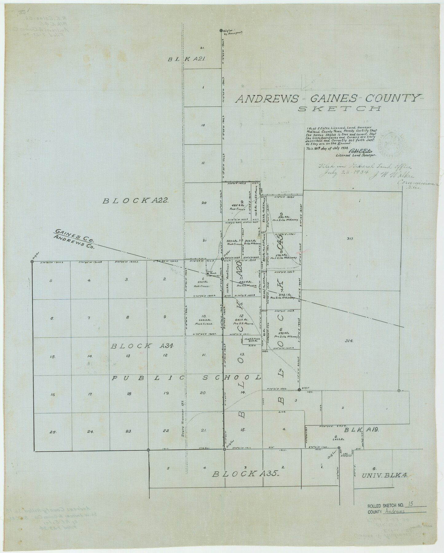
Andrews County Rolled Sketch 15
[Sketch of surveys in PSL Blocks A34, A35, A20, and C45 along Andrews-Gaines County line]
-
Map/Doc
77166
-
Collection
General Map Collection
-
Object Dates
1934/7/29 (Creation Date)
1934/7/23 (File Date)
-
People and Organizations
Robt. E. Estes (Surveyor/Engineer)
-
Counties
Andrews Gaines
-
Subjects
Surveying Rolled Sketch
-
Height x Width
27.9 x 22.4 inches
70.9 x 56.9 cm
-
Medium
linen, manuscript
Part of: General Map Collection
Map of El Paso County

Print $20.00
- Digital $50.00
Map of El Paso County
1888
Size 47.1 x 39.5 inches
Map/Doc 4942
Chocolate Bay, West Portion of West Bay and Vicinity, Brazoria and Galveston Counties, showing Subdivision for Mineral Development

Print $40.00
- Digital $50.00
Chocolate Bay, West Portion of West Bay and Vicinity, Brazoria and Galveston Counties, showing Subdivision for Mineral Development
1948
Size 40.7 x 53.9 inches
Map/Doc 1907
Cuadro Historico-Geroglifico de la Peregrinacion de las Tribus Aztecas que Poblaron el Valle de Mexico (Num. 1)

Print $20.00
- Digital $50.00
Cuadro Historico-Geroglifico de la Peregrinacion de las Tribus Aztecas que Poblaron el Valle de Mexico (Num. 1)
Size 22.9 x 31.2 inches
Map/Doc 97013
Flight Mission No. CUG-1P, Frame 26, Kleberg County

Print $20.00
- Digital $50.00
Flight Mission No. CUG-1P, Frame 26, Kleberg County
1956
Size 18.6 x 22.2 inches
Map/Doc 86116
Angelina County Working Sketch 55

Print $20.00
- Digital $50.00
Angelina County Working Sketch 55
1989
Size 33.7 x 30.0 inches
Map/Doc 67139
San Patricio County Working Sketch 3

Print $20.00
- Digital $50.00
San Patricio County Working Sketch 3
Size 22.2 x 42.7 inches
Map/Doc 63765
Culberson County Rolled Sketch 34

Print $20.00
- Digital $50.00
Culberson County Rolled Sketch 34
1938
Size 43.5 x 43.6 inches
Map/Doc 8749
Galveston Island

Print $20.00
- Digital $50.00
Galveston Island
1837
Size 24.1 x 37.2 inches
Map/Doc 2009
Flight Mission No. BRA-16M, Frame 112, Jefferson County

Print $20.00
- Digital $50.00
Flight Mission No. BRA-16M, Frame 112, Jefferson County
1953
Size 18.6 x 22.2 inches
Map/Doc 85722
Eastland County Boundary File 13

Print $68.00
- Digital $50.00
Eastland County Boundary File 13
Size 8.0 x 3.7 inches
Map/Doc 52785
Map of Padre Island Showing Location of Zoning Districts

Print $20.00
- Digital $50.00
Map of Padre Island Showing Location of Zoning Districts
1971
Size 18.8 x 26.7 inches
Map/Doc 4809
Webb County Rolled Sketch 31

Print $20.00
- Digital $50.00
Webb County Rolled Sketch 31
Size 38.8 x 44.5 inches
Map/Doc 10122
You may also like
Lavaca County Working Sketch 19

Print $4.00
- Digital $50.00
Lavaca County Working Sketch 19
1980
Size 26.9 x 29.6 inches
Map/Doc 70372
McMullen County Working Sketch 2

Print $20.00
- Digital $50.00
McMullen County Working Sketch 2
1919
Size 30.9 x 19.2 inches
Map/Doc 70703
Hunt County, Texas

Print $20.00
- Digital $50.00
Hunt County, Texas
1871
Size 25.8 x 19.4 inches
Map/Doc 462
No. 3 Chart of Channel connecting Corpus Christi Bay with Aransas Bay, Texas

Print $20.00
- Digital $50.00
No. 3 Chart of Channel connecting Corpus Christi Bay with Aransas Bay, Texas
1878
Size 18.1 x 27.9 inches
Map/Doc 72776
Colorado County Sketch File 9

Print $3.00
- Digital $50.00
Colorado County Sketch File 9
Size 11.3 x 17.0 inches
Map/Doc 11134
[Blocks M18, M23, I, Z, and Block 47, Sections 16-28]
![91244, [Blocks M18, M23, I, Z, and Block 47, Sections 16-28], Twichell Survey Records](https://historictexasmaps.com/wmedia_w700/maps/91244-1.tif.jpg)
Print $20.00
- Digital $50.00
[Blocks M18, M23, I, Z, and Block 47, Sections 16-28]
Size 19.5 x 23.6 inches
Map/Doc 91244
Flight Mission No. BRA-16M, Frame 100, Jefferson County

Print $20.00
- Digital $50.00
Flight Mission No. BRA-16M, Frame 100, Jefferson County
1953
Size 18.4 x 19.2 inches
Map/Doc 85712

Flight Mission No. CGI-1N, Frame 173, Cameron County

Print $20.00
- Digital $50.00
Flight Mission No. CGI-1N, Frame 173, Cameron County
1955
Size 18.5 x 22.1 inches
Map/Doc 84508
The Republic County of Robertson. January 30, 1841

Print $20.00
The Republic County of Robertson. January 30, 1841
2020
Size 16.9 x 21.7 inches
Map/Doc 96261
Henderson County Sketch File 10

Print $4.00
- Digital $50.00
Henderson County Sketch File 10
1859
Size 12.8 x 8.3 inches
Map/Doc 26346
Falls County Working Sketch Graphic Index

Print $20.00
- Digital $50.00
Falls County Working Sketch Graphic Index
1976
Size 39.7 x 44.2 inches
Map/Doc 76539