Maps of Gulf Intracoastal Waterway, Texas - Sabine River to the Rio Grande and connecting waterways including ship channels
-
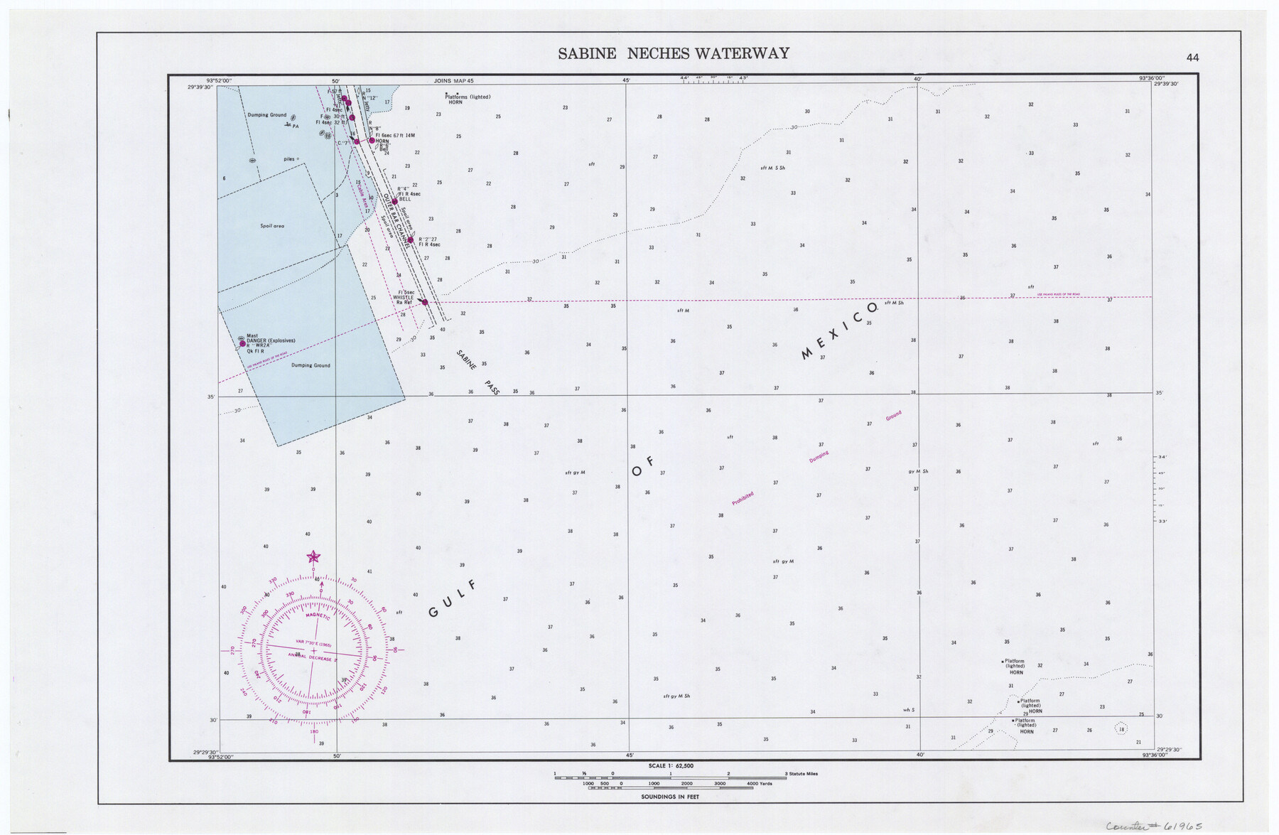
Map/Doc
61965
-
Collection
General Map Collection
-
Object Dates
1966 (Creation Date)
-
Subjects
Intracoastal Waterways
-
Height x Width
14.6 x 22.3 inches
37.1 x 56.6 cm
Part of: General Map Collection
Hartley County Sketch File 9

Print $12.00
- Digital $50.00
Hartley County Sketch File 9
1903
Size 10.8 x 7.2 inches
Map/Doc 26094
Bandera County Working Sketch 56

Print $20.00
- Digital $50.00
Bandera County Working Sketch 56
1991
Size 28.1 x 35.1 inches
Map/Doc 67652
Dickens County Working Sketch 10

Print $40.00
- Digital $50.00
Dickens County Working Sketch 10
1965
Size 62.2 x 39.5 inches
Map/Doc 68658
Real County Working Sketch 81

Print $20.00
- Digital $50.00
Real County Working Sketch 81
1984
Size 19.9 x 17.1 inches
Map/Doc 71973
Upton County Rolled Sketch 27

Print $40.00
- Digital $50.00
Upton County Rolled Sketch 27
1945
Size 42.1 x 62.1 inches
Map/Doc 10046
Bowie County Sketch File 7a

Print $30.00
- Digital $50.00
Bowie County Sketch File 7a
1927
Size 11.2 x 8.7 inches
Map/Doc 14854
A How to Get From Here to There Map and Water Too of Metropolitan Houston

A How to Get From Here to There Map and Water Too of Metropolitan Houston
Size 36.6 x 25.5 inches
Map/Doc 94361
Cooke County Working Sketch 3

Print $20.00
- Digital $50.00
Cooke County Working Sketch 3
1926
Size 27.5 x 39.9 inches
Map/Doc 68240
Starr County Rolled Sketch 10

Print $20.00
- Digital $50.00
Starr County Rolled Sketch 10
1912
Size 15.2 x 24.0 inches
Map/Doc 7797

Map of the County of Cameron

Print $40.00
- Digital $50.00
Map of the County of Cameron
1884
Size 59.4 x 35.8 inches
Map/Doc 76058
Reeves County Sketch File 4

Print $20.00
- Digital $50.00
Reeves County Sketch File 4
Size 32.8 x 12.2 inches
Map/Doc 12240
You may also like

South Part of El Paso Co.

Print $20.00
- Digital $50.00
South Part of El Paso Co.
1977
Size 30.5 x 40.8 inches
Map/Doc 77274
[J. Poitevent Block 1]
![90620, [J. Poitevent Block 1], Twichell Survey Records](https://historictexasmaps.com/wmedia_w700/maps/90620-1.tif.jpg)
Print $2.00
- Digital $50.00
[J. Poitevent Block 1]
Size 9.0 x 11.5 inches
Map/Doc 90620
Howard County Boundary File 2a

Print $9.00
- Digital $50.00
Howard County Boundary File 2a
Size 14.6 x 11.3 inches
Map/Doc 55118
The MKT - Texas Empire of the South

Print $20.00
- Digital $50.00
The MKT - Texas Empire of the South
1905
Size 18.5 x 40.6 inches
Map/Doc 97035
Grimes County Rolled Sketch 1

Print $20.00
- Digital $50.00
Grimes County Rolled Sketch 1
1945
Size 34.6 x 35.0 inches
Map/Doc 9007
Reagan County Sketch File 2B

Print $20.00
- Digital $50.00
Reagan County Sketch File 2B
Size 20.4 x 22.2 inches
Map/Doc 12212
The North Part of America Conteyning Newfoundland, New England, Virginia, Florida, New Spaine, and Nova Francia

Print $20.00
- Digital $50.00
The North Part of America Conteyning Newfoundland, New England, Virginia, Florida, New Spaine, and Nova Francia
1625
Size 12.6 x 16.2 inches
Map/Doc 97028
Burnet County Working Sketch 25

Print $20.00
- Digital $50.00
Burnet County Working Sketch 25
2000
Size 24.2 x 30.3 inches
Map/Doc 67868
North Sulphur River, Bartley Gin Sheet

Print $20.00
- Digital $50.00
North Sulphur River, Bartley Gin Sheet
1928
Size 13.3 x 22.0 inches
Map/Doc 78323
[Subdivision surveys of the McCutcheon League near the Bastrop-Caldwell County Line]
![90148, [Subdivision surveys of the McCutcheon League near the Bastrop-Caldwell County Line], Twichell Survey Records](https://historictexasmaps.com/wmedia_w700/maps/90148-1.tif.jpg)
Print $20.00
- Digital $50.00
[Subdivision surveys of the McCutcheon League near the Bastrop-Caldwell County Line]
1923
Size 12.5 x 16.9 inches
Map/Doc 90148
Starr County Rolled Sketch 23

Print $20.00
- Digital $50.00
Starr County Rolled Sketch 23
1938
Size 36.8 x 24.9 inches
Map/Doc 7807