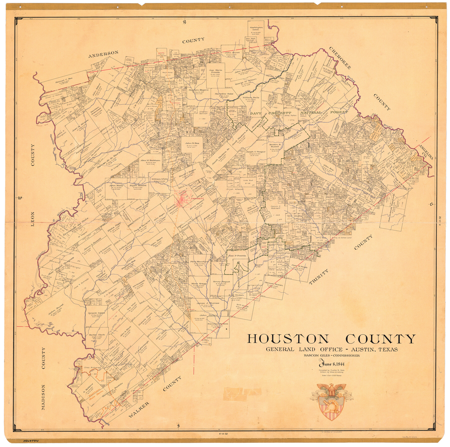
Houston County
-
Map/Doc
73184
-
Collection
General Map Collection
-
Object Dates
1944/6/6 (Creation Date)
-
People and Organizations
Texas General Land Office (Publisher)
Curtis R. Hale (Compiler)
Bascom Giles (GLO Commissioner)
Eltea Armstrong (Draftsman)
-
Counties
Houston
-
Subjects
County
-
Height x Width
50.3 x 50.3 inches
127.8 x 127.8 cm
-
Medium
paper, manuscript
-
Comments
Features a drawing of the West Point crest in the bottom right-hand corner and the inscription "Lt. J.B. Giles Jr - June 6, 1944". This was a tribute to Commissioner Giles' son, a West Point graduate, for "D-Day".
-
Features
Robbins Ferry
Collins Creek
Box Creek
White Rock Creek
Cairo Bluff
Caney Bayou
Lovelady
Lost Creek
Rattlesnake Lake
Long Lake
Pape Lake
Patterson Lake
Duck Lake
Dry Lake
McKenzie Lake
Piney Creek
Flat Island
Dickey Creek
Brushy Lake
Kellison Creek
Clarks Bayou
Tantabogue Creek
Westmorland Bluff
Hyde Lake
Spanish Bluff
Negro Creek
Randolph Bluff
Elkhart Creek
Wright Creek
Rock Creek
Conners Creek
Camp Creek
Neches River
Bracken Creek
Davis Creek
Grapeland
Salmon
Mitchell Bend
Mitchell Bluff
Big Elkhart Creek
Stanmire Lake
Davy Crockett National Forest
Walnut Creek
Rose Bayou
Sikes Creek
San Pedro Creek
Little Elkhart Creek
Flat Lake
Clear Lake
Halls Bluff
Hurricane Bayou
Cochino Bayou
Bristow Creek
Lynch Creek
Crockett
Horseshoe Lake
Dean Lake
Brookfield Bluff
Trinity River
I&GN
Part of: General Map Collection
Polk County Sketch File 27

Print $8.00
- Digital $50.00
Polk County Sketch File 27
1891
Size 14.1 x 8.7 inches
Map/Doc 34194
Crockett County Working Sketch 22

Print $20.00
- Digital $50.00
Crockett County Working Sketch 22
1920
Size 25.6 x 19.5 inches
Map/Doc 68355
Jeff Davis County Working Sketch 42

Print $20.00
- Digital $50.00
Jeff Davis County Working Sketch 42
1983
Size 42.7 x 46.7 inches
Map/Doc 66537
Hopkins County

Print $20.00
- Digital $50.00
Hopkins County
1942
Size 44.1 x 40.9 inches
Map/Doc 73183
Hudspeth County Rolled Sketch 66

Print $20.00
- Digital $50.00
Hudspeth County Rolled Sketch 66
1973
Size 12.0 x 19.0 inches
Map/Doc 6262
Erath County Working Sketch 52

Print $20.00
- Digital $50.00
Erath County Working Sketch 52
1992
Size 33.9 x 33.6 inches
Map/Doc 69134
Hockley County Working Sketch 4

Print $40.00
- Digital $50.00
Hockley County Working Sketch 4
1973
Size 38.7 x 52.3 inches
Map/Doc 66194
Navarro County Sketch File 3

Print $8.00
- Digital $50.00
Navarro County Sketch File 3
1847
Size 10.2 x 8.1 inches
Map/Doc 32300
Freestone County Working Sketch 30

Print $20.00
- Digital $50.00
Freestone County Working Sketch 30
Size 29.5 x 37.2 inches
Map/Doc 69272
Karnes County Sketch File 4

Print $8.00
- Digital $50.00
Karnes County Sketch File 4
1852
Size 5.5 x 6.8 inches
Map/Doc 28550
Montague County Sketch File 20

Print $42.00
- Digital $50.00
Montague County Sketch File 20
1923
Size 34.6 x 19.8 inches
Map/Doc 12106
Leon County Sketch File 31

Print $20.00
- Digital $50.00
Leon County Sketch File 31
Size 19.1 x 20.5 inches
Map/Doc 11993
You may also like
Texas Intracoastal Waterway, Aransas Bay to Aransas Pass

Print $20.00
- Digital $50.00
Texas Intracoastal Waterway, Aransas Bay to Aransas Pass
1957
Size 38.9 x 27.6 inches
Map/Doc 73437
Fort Bend County Sketch File 36

Print $6.00
- Digital $50.00
Fort Bend County Sketch File 36
1997
Size 11.4 x 8.9 inches
Map/Doc 23007
[Capitol Lands in Lamb County]
![90996, [Capitol Lands in Lamb County], Twichell Survey Records](https://historictexasmaps.com/wmedia_w700/maps/90996-1.tif.jpg)
Print $20.00
- Digital $50.00
[Capitol Lands in Lamb County]
1903
Size 31.0 x 11.8 inches
Map/Doc 90996
[North line of County]
![93146, [North line of County], Twichell Survey Records](https://historictexasmaps.com/wmedia_w700/maps/93146-1.tif.jpg)
Print $40.00
- Digital $50.00
[North line of County]
Size 76.2 x 8.6 inches
Map/Doc 93146
Hopkins County Sketch File 29

Print $4.00
- Digital $50.00
Hopkins County Sketch File 29
1873
Size 10.0 x 8.1 inches
Map/Doc 26740
Upshur County Sketch File 15

Print $20.00
- Digital $50.00
Upshur County Sketch File 15
1934
Size 20.7 x 31.2 inches
Map/Doc 12505

General Highway Map, Bosque County, Texas

Print $20.00
General Highway Map, Bosque County, Texas
1940
Size 25.3 x 18.5 inches
Map/Doc 79022
Tarrant County Sketch File 29a

Print $4.00
- Digital $50.00
Tarrant County Sketch File 29a
1876
Size 8.2 x 12.8 inches
Map/Doc 37747
Eastland County Sketch File 2b

Print $6.00
- Digital $50.00
Eastland County Sketch File 2b
1857
Size 11.1 x 8.8 inches
Map/Doc 21563
Hutchinson County Sketch File 45

Print $22.00
- Digital $50.00
Hutchinson County Sketch File 45
1991
Size 11.1 x 8.8 inches
Map/Doc 27354
Upton County Sketch File 5

Print $40.00
- Digital $50.00
Upton County Sketch File 5
Size 8.7 x 24.4 inches
Map/Doc 38813