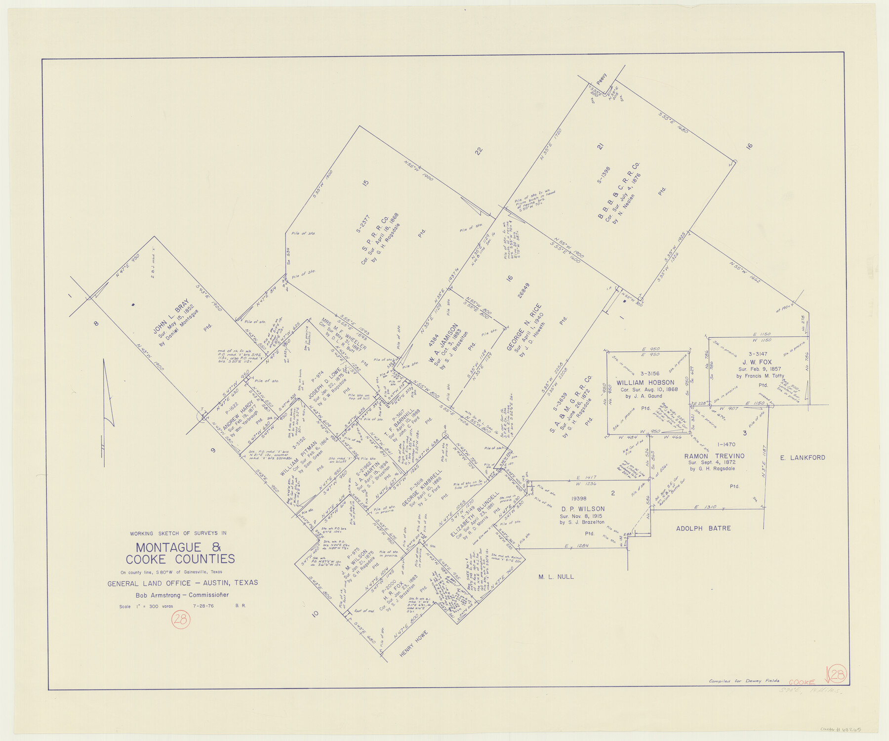
Cooke County Working Sketch 28
-
Map/Doc
68265
-
Collection
General Map Collection
-
Object Dates
7/28/1976 (Creation Date)
-
People and Organizations
Beverly Robison (Draftsman)
-
Counties
Cooke Montague
-
Subjects
Surveying Working Sketch
-
Height x Width
28.4 x 34.1 inches
72.1 x 86.6 cm
-
Scale
1" = 300 varas
Part of: General Map Collection
Hale County Sketch File 20

Print $6.00
- Digital $50.00
Hale County Sketch File 20
Size 15.7 x 10.5 inches
Map/Doc 24753
Duval County Rolled Sketch OS

Print $20.00
- Digital $50.00
Duval County Rolled Sketch OS
1903
Size 36.0 x 31.9 inches
Map/Doc 8803
Port of Galveston

Print $40.00
- Digital $50.00
Port of Galveston
1978
Size 20.0 x 68.9 inches
Map/Doc 83336
Aransas Pass to Baffin Bay

Print $20.00
- Digital $50.00
Aransas Pass to Baffin Bay
1938
Size 41.6 x 34.5 inches
Map/Doc 73411
Loving County Rolled Sketch 3

Print $40.00
- Digital $50.00
Loving County Rolled Sketch 3
Size 13.9 x 145.3 inches
Map/Doc 9464
Live Oak County Working Sketch 14

Print $20.00
- Digital $50.00
Live Oak County Working Sketch 14
1949
Size 27.9 x 42.1 inches
Map/Doc 70599
El Paso County Rolled Sketch 56

Print $20.00
- Digital $50.00
El Paso County Rolled Sketch 56
1982
Size 33.5 x 36.6 inches
Map/Doc 8878
Flight Mission No. CRC-4R, Frame 93, Chambers County

Print $20.00
- Digital $50.00
Flight Mission No. CRC-4R, Frame 93, Chambers County
1956
Size 18.4 x 22.3 inches
Map/Doc 84890
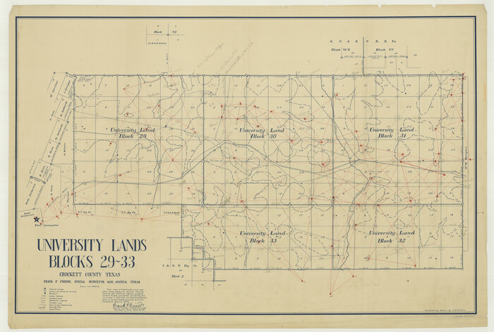
University Lands Blocks 29-33, Crockett County, Texas
Print $20.00
- Digital $50.00
University Lands Blocks 29-33, Crockett County, Texas
Size 29.7 x 44.1 inches
Map/Doc 62943
Amistad International Reservoir on Rio Grande 68a

Print $20.00
- Digital $50.00
Amistad International Reservoir on Rio Grande 68a
1949
Size 28.4 x 39.6 inches
Map/Doc 73354
Presidio County Working Sketch 137

Print $20.00
- Digital $50.00
Presidio County Working Sketch 137
1990
Size 24.1 x 42.8 inches
Map/Doc 71815
Houston County Rolled Sketch 9

Print $20.00
- Digital $50.00
Houston County Rolled Sketch 9
1980
Size 27.5 x 26.6 inches
Map/Doc 6229
You may also like
East Part of Houston County

Print $40.00
- Digital $50.00
East Part of Houston County
1944
Size 49.0 x 42.1 inches
Map/Doc 77316
Bowie County Working Sketch 24

Print $20.00
- Digital $50.00
Bowie County Working Sketch 24
1974
Size 47.1 x 40.1 inches
Map/Doc 67428
Amistad International Reservoir on Rio Grande 96

Print $20.00
- Digital $50.00
Amistad International Reservoir on Rio Grande 96
1950
Size 28.5 x 41.0 inches
Map/Doc 75527
[Blocks C4, SI, and JK]
![90778, [Blocks C4, SI, and JK], Twichell Survey Records](https://historictexasmaps.com/wmedia_w700/maps/90778-1.tif.jpg)
Print $20.00
- Digital $50.00
[Blocks C4, SI, and JK]
Size 15.0 x 13.3 inches
Map/Doc 90778
Texas, the Empire State of the Southwest

Texas, the Empire State of the Southwest
1909
Size 9.7 x 5.4 inches
Map/Doc 96603
Crockett County Sketch File 53

Print $10.00
- Digital $50.00
Crockett County Sketch File 53
1903
Size 11.4 x 8.9 inches
Map/Doc 19819
Flight Mission No. CRK-5P, Frame 128, Refugio County

Print $20.00
- Digital $50.00
Flight Mission No. CRK-5P, Frame 128, Refugio County
1956
Size 18.6 x 22.5 inches
Map/Doc 86931
Ellis County Sketch File 18a

Print $40.00
- Digital $50.00
Ellis County Sketch File 18a
Size 12.8 x 16.0 inches
Map/Doc 21864
[Worksheets related to the Wilson Strickland survey and vicinity]
![91268, [Vicinity and related to the Wilson Strickland Survey], Twichell Survey Records](https://historictexasmaps.com/wmedia_w700/maps/91268-1.tif.jpg)
Print $20.00
- Digital $50.00
[Worksheets related to the Wilson Strickland survey and vicinity]
Size 21.1 x 18.9 inches
Map/Doc 91268
Reagan County Working Sketch 46b

Print $20.00
- Digital $50.00
Reagan County Working Sketch 46b
1987
Size 31.4 x 45.2 inches
Map/Doc 71889
Boundary Line Between Texas and New Mexico, Supreme Court Decision - Oct. Term, 1930

Print $304.00
Boundary Line Between Texas and New Mexico, Supreme Court Decision - Oct. Term, 1930
1930
Map/Doc 81688
[Beaumont, Sour Lake and Western Ry. Right of Way and Alignment - Frisco]
![64125, [Beaumont, Sour Lake and Western Ry. Right of Way and Alignment - Frisco], General Map Collection](https://historictexasmaps.com/wmedia_w700/maps/64125.tif.jpg)
Print $20.00
- Digital $50.00
[Beaumont, Sour Lake and Western Ry. Right of Way and Alignment - Frisco]
1910
Size 20.1 x 45.9 inches
Map/Doc 64125