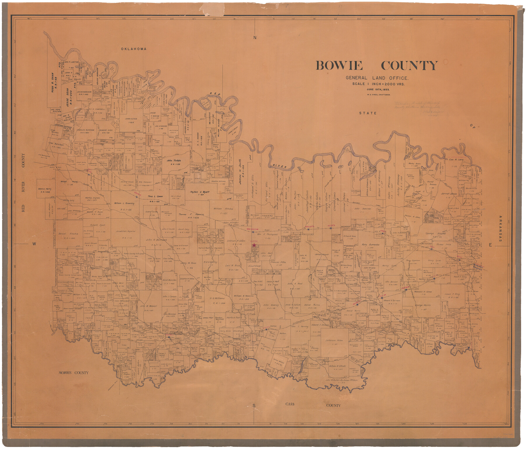
Bowie County
-
Map/Doc
73084
-
Collection
General Map Collection
-
Object Dates
1933/6/19 (Creation Date)
-
People and Organizations
Texas General Land Office (Publisher)
W.S. Vines (Draftsman)
-
Counties
Bowie
-
Subjects
County
-
Height x Width
40.8 x 47.7 inches
103.6 x 121.2 cm
-
Comments
Hand lettered.
-
Features
Redwater Station
Godley's Creek
Rice's Creek
Caney Creek
Elliott's Creek
McKinney's Creek
Downey's Creek
Eylau Station
Texarkana
Ward's Creek
Hartman Station
Harbors Creek
Trexler Station
Barr's Creek
Rocky Creek
Langham's Creek
Weavers Creek
T&P
Corley Station
SLS
Brook's Creek
Bassett Station
Little Piney Creek
Bassett's Creek
Ead's Creek
Blythe's Creek
Bear Slough
McFarland's Bayou
Sulphur Station
McFarland's Lake
Sulphur Fork
Stephensons Ferry
Mill Bayou
Mill Creek
Red River
Red Bayou
Phillips Marsh
Mill Creek Lake
East Prong of Mill Creek
Pine Lake
McKinney Lake
North Prong of Mud Creek
Fish Lake
Ginhouse Lake
Wilsons Lake
Byers Lake
Carters Lake
McKinneys Bayou
Ash Slough
Big Lake
Collums Spring Branch Creek
Mud Creek
Oak Grove
Young's Fork of Andersons Creek
Andersons Creek
New Boston
Boston
T&P
Whaley's Station
Hook's Station
Leary
Trammels [sic] Trace
Argo
Nash
Part of: General Map Collection
Karnes County Rolled Sketch 3A

Print $20.00
- Digital $50.00
Karnes County Rolled Sketch 3A
1959
Size 23.9 x 28.6 inches
Map/Doc 6455
Knox County Working Sketch 4

Print $20.00
- Digital $50.00
Knox County Working Sketch 4
1919
Size 18.0 x 25.6 inches
Map/Doc 70246
Webb County Working Sketch 4

Print $20.00
- Digital $50.00
Webb County Working Sketch 4
1907
Size 45.6 x 42.5 inches
Map/Doc 72369
Haskell County Sketch File 20

Print $20.00
- Digital $50.00
Haskell County Sketch File 20
1902
Size 20.9 x 26.2 inches
Map/Doc 11743
Galveston County

Print $40.00
- Digital $50.00
Galveston County
1939
Size 44.6 x 59.1 inches
Map/Doc 66835
Montgomery County Sketch File 10

Print $4.00
- Digital $50.00
Montgomery County Sketch File 10
Size 16.2 x 9.2 inches
Map/Doc 31798
Culberson County Sketch File 39

Print $12.00
- Digital $50.00
Culberson County Sketch File 39
1968
Size 11.2 x 8.7 inches
Map/Doc 20306
Floyd County Sketch File 18

Print $32.00
- Digital $50.00
Floyd County Sketch File 18
1913
Size 13.4 x 9.0 inches
Map/Doc 22753
Map of Tyler County

Print $20.00
- Digital $50.00
Map of Tyler County
1897
Size 42.2 x 39.2 inches
Map/Doc 63081
Navarro County Sketch File 22

Print $6.00
- Digital $50.00
Navarro County Sketch File 22
1873
Size 10.0 x 8.0 inches
Map/Doc 32352
Liberty County Working Sketch 71

Print $20.00
- Digital $50.00
Liberty County Working Sketch 71
1977
Size 37.3 x 31.8 inches
Map/Doc 70531
Dickens County Boundary File 5

Print $12.00
- Digital $50.00
Dickens County Boundary File 5
Size 10.8 x 8.2 inches
Map/Doc 52554
You may also like
The Chief Justice County of Refugio. Proposed, No Date

Print $20.00
The Chief Justice County of Refugio. Proposed, No Date
2020
Size 22.6 x 21.7 inches
Map/Doc 96067
Austin County Sketch File 15

Print $12.00
- Digital $50.00
Austin County Sketch File 15
Size 9.5 x 8.2 inches
Map/Doc 13882
Young County Working Sketch 9

Print $20.00
- Digital $50.00
Young County Working Sketch 9
1921
Size 25.9 x 36.6 inches
Map/Doc 62032
Starr County Working Sketch 23

Print $20.00
- Digital $50.00
Starr County Working Sketch 23
1984
Size 29.9 x 30.6 inches
Map/Doc 63939
Flight Mission No. BRE-1P, Frame 49, Nueces County

Print $20.00
- Digital $50.00
Flight Mission No. BRE-1P, Frame 49, Nueces County
1956
Size 18.4 x 22.2 inches
Map/Doc 86638
Old Miscellaneous File 22

Print $18.00
- Digital $50.00
Old Miscellaneous File 22
1915
Size 14.2 x 8.7 inches
Map/Doc 75591
Van Zandt County

Print $20.00
- Digital $50.00
Van Zandt County
1921
Size 45.5 x 41.0 inches
Map/Doc 16914
Flight Mission No. DIX-8P, Frame 95, Aransas County

Print $20.00
- Digital $50.00
Flight Mission No. DIX-8P, Frame 95, Aransas County
1956
Size 18.4 x 22.3 inches
Map/Doc 83920
Lamb County Working Sketch Graphic Index

Print $20.00
- Digital $50.00
Lamb County Working Sketch Graphic Index
1961
Size 43.8 x 34.1 inches
Map/Doc 76613
Index Map No. 1 - Rio Bravo del Norte section of boundary between the United States & Mexico; agreed upon by the Joint Commission under the Treaty of Guadalupe Hidalgo

Print $20.00
- Digital $50.00
Index Map No. 1 - Rio Bravo del Norte section of boundary between the United States & Mexico; agreed upon by the Joint Commission under the Treaty of Guadalupe Hidalgo
1852
Size 18.3 x 27.5 inches
Map/Doc 72861
No. 1 - Survey for a road from the Brazo Santiago to the Rio Grande

Print $20.00
- Digital $50.00
No. 1 - Survey for a road from the Brazo Santiago to the Rio Grande
1847
Size 18.3 x 27.0 inches
Map/Doc 72873
