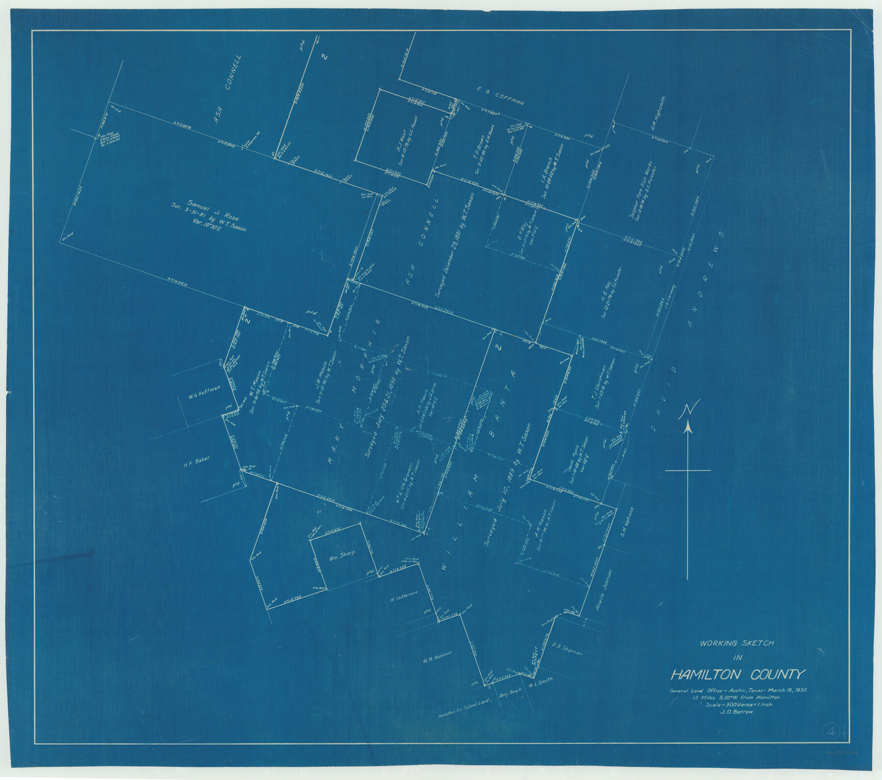
Hamilton County Working Sketch 4
-
Map/Doc
63342
-
Collection
General Map Collection
-
Object Dates
3/19/1935 (Creation Date)
-
People and Organizations
J.O. Barrow (Draftsman)
-
Counties
Hamilton
-
Subjects
Surveying Working Sketch
-
Height x Width
32.6 x 36.9 inches
82.8 x 93.7 cm
-
Scale
1" = 300 varas
Part of: General Map Collection
Kinney County Working Sketch 21

Print $20.00
- Digital $50.00
Kinney County Working Sketch 21
1950
Size 23.7 x 18.5 inches
Map/Doc 70203
Gregg County Rolled Sketch 7

Print $20.00
- Digital $50.00
Gregg County Rolled Sketch 7
1933
Size 24.6 x 42.0 inches
Map/Doc 6032
Concho County Rolled Sketch 51

Print $20.00
- Digital $50.00
Concho County Rolled Sketch 51
1967
Size 31.0 x 25.5 inches
Map/Doc 5559
Leon County Working Sketch 35

Print $20.00
- Digital $50.00
Leon County Working Sketch 35
1978
Size 43.8 x 38.3 inches
Map/Doc 70434
Harris County Working Sketch 22

Print $20.00
- Digital $50.00
Harris County Working Sketch 22
Size 17.5 x 22.0 inches
Map/Doc 65914
Hudspeth County Rolled Sketch 45

Print $20.00
- Digital $50.00
Hudspeth County Rolled Sketch 45
1958
Size 20.5 x 35.6 inches
Map/Doc 6254
Liberty County Rolled Sketch JLW

Print $40.00
- Digital $50.00
Liberty County Rolled Sketch JLW
1935
Size 28.0 x 85.5 inches
Map/Doc 9665
Bell County Sketch File 35

Print $40.00
- Digital $50.00
Bell County Sketch File 35
1952
Size 22.0 x 24.3 inches
Map/Doc 10918
Pecos County Sketch File 44

Print $8.00
- Digital $50.00
Pecos County Sketch File 44
Size 13.0 x 10.4 inches
Map/Doc 33743
Chambers County Working Sketch 21
Print $20.00
- Digital $50.00
Chambers County Working Sketch 21
1974
Size 44.1 x 34.8 inches
Map/Doc 68004
Fannin County Sketch File 20a

Print $7.00
- Digital $50.00
Fannin County Sketch File 20a
1889
Size 10.4 x 8.4 inches
Map/Doc 22482
Franklin County Working Sketch 3

Print $20.00
- Digital $50.00
Franklin County Working Sketch 3
1956
Size 19.5 x 16.1 inches
Map/Doc 69241
You may also like
Jim Hogg County Sketch File 6a

Print $6.00
- Digital $50.00
Jim Hogg County Sketch File 6a
1939
Size 11.1 x 8.7 inches
Map/Doc 28408
The Mexican Municipality of San Augustine. December 15, 1835

Print $20.00
The Mexican Municipality of San Augustine. December 15, 1835
2020
Size 24.1 x 21.7 inches
Map/Doc 96033
Comal County Sketch File 12

Print $4.00
- Digital $50.00
Comal County Sketch File 12
Size 8.4 x 11.3 inches
Map/Doc 19024
Schleicher County Working Sketch 10

Print $20.00
- Digital $50.00
Schleicher County Working Sketch 10
1923
Size 18.3 x 16.4 inches
Map/Doc 63812
Goliad County Working Sketch 22

Print $20.00
- Digital $50.00
Goliad County Working Sketch 22
1971
Size 33.1 x 36.8 inches
Map/Doc 63212
Orange County Sketch File 11

Print $42.00
- Digital $50.00
Orange County Sketch File 11
1876
Size 12.8 x 16.5 inches
Map/Doc 33319
Randall County Sketch File 8

Print $20.00
- Digital $50.00
Randall County Sketch File 8
Size 18.1 x 23.1 inches
Map/Doc 12209
Ector County Working Sketch 24

Print $40.00
- Digital $50.00
Ector County Working Sketch 24
1961
Size 42.2 x 51.7 inches
Map/Doc 68867
Presidio County Sketch File 105

Print $20.00
- Digital $50.00
Presidio County Sketch File 105
Size 15.6 x 42.6 inches
Map/Doc 11726
McCulloch County Working Sketch 9

Print $20.00
- Digital $50.00
McCulloch County Working Sketch 9
1978
Size 35.6 x 32.7 inches
Map/Doc 70684
Coast Chart No. 105 - Galveston Bay to Oyster Bay, Texas

Print $20.00
- Digital $50.00
Coast Chart No. 105 - Galveston Bay to Oyster Bay, Texas
1884
Size 24.1 x 29.6 inches
Map/Doc 69926
