Borden County Sketch File 3a
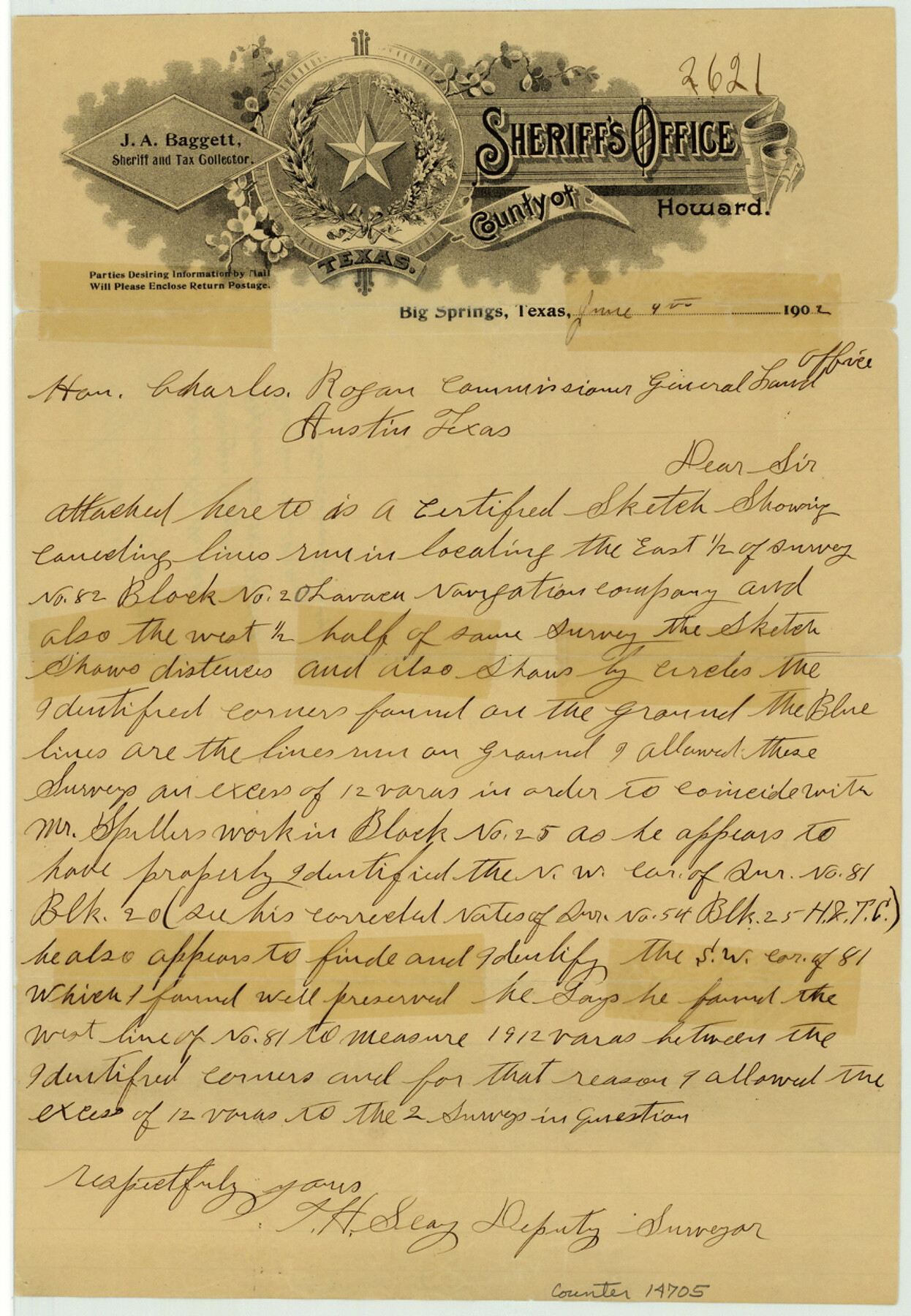
[Explanation by surveyor in regard to surveys in southeast corner of county]
-
Map/Doc
14705
-
Collection
General Map Collection
-
Object Dates
1902/6/9 (Creation Date)
1902/6/13 (File Date)
-
People and Organizations
T.H. Seay (Surveyor/Engineer)
-
Counties
Borden
-
Subjects
Surveying Sketch File
-
Height x Width
12.5 x 8.6 inches
31.8 x 21.8 cm
-
Medium
paper, manuscript
-
Comments
See Borden County Sketch File 3 (14703) for sketch.
Related maps
Borden County Sketch File 3

Print $4.00
- Digital $50.00
Borden County Sketch File 3
1902
Size 7.3 x 12.8 inches
Map/Doc 14703
Part of: General Map Collection
Morris County Rolled Sketch 2A

Print $20.00
- Digital $50.00
Morris County Rolled Sketch 2A
Size 22.6 x 17.7 inches
Map/Doc 10285
Brewster County Rolled Sketch 19A

Print $20.00
- Digital $50.00
Brewster County Rolled Sketch 19A
1881
Size 31.5 x 38.6 inches
Map/Doc 8471
Flight Mission No. DQO-8K, Frame 64, Galveston County

Print $20.00
- Digital $50.00
Flight Mission No. DQO-8K, Frame 64, Galveston County
1952
Size 18.6 x 22.4 inches
Map/Doc 85168
Hardin County Working Sketch 26

Print $20.00
- Digital $50.00
Hardin County Working Sketch 26
1954
Size 19.5 x 23.8 inches
Map/Doc 63424
Brazoria County Working Sketch 21

Print $20.00
- Digital $50.00
Brazoria County Working Sketch 21
1954
Size 41.5 x 41.8 inches
Map/Doc 67506
West Part Presidio Co.

Print $20.00
- Digital $50.00
West Part Presidio Co.
1974
Size 42.1 x 33.3 inches
Map/Doc 73267
Packery Channel

Print $20.00
- Digital $50.00
Packery Channel
1975
Size 26.2 x 21.5 inches
Map/Doc 2991
[The S.K. Ry. of Texas, State Line to Pecos, Reeves Co., Texas]
![64159, [The S.K. Ry. of Texas, State Line to Pecos, Reeves Co., Texas], General Map Collection](https://historictexasmaps.com/wmedia_w700/maps/64159.tif.jpg)
Print $40.00
- Digital $50.00
[The S.K. Ry. of Texas, State Line to Pecos, Reeves Co., Texas]
1910
Size 19.4 x 130.6 inches
Map/Doc 64159
Garza County Rolled Sketch 9

Print $20.00
- Digital $50.00
Garza County Rolled Sketch 9
1913
Size 33.8 x 43.8 inches
Map/Doc 9054
Cass County Working Sketch 35

Print $20.00
- Digital $50.00
Cass County Working Sketch 35
1982
Size 23.5 x 44.8 inches
Map/Doc 67938
Flight Mission No. BRA-7M, Frame 146, Jefferson County

Print $20.00
- Digital $50.00
Flight Mission No. BRA-7M, Frame 146, Jefferson County
1953
Size 16.1 x 16.1 inches
Map/Doc 85540
Bexar County Working Sketch 15

Print $20.00
- Digital $50.00
Bexar County Working Sketch 15
1972
Size 38.3 x 43.3 inches
Map/Doc 67331
You may also like
Blanco County Sketch File 8

Print $4.00
- Digital $50.00
Blanco County Sketch File 8
Size 8.1 x 12.8 inches
Map/Doc 14584
Shelby County Working Sketch 19

Print $20.00
- Digital $50.00
Shelby County Working Sketch 19
1969
Size 36.9 x 30.2 inches
Map/Doc 63872
[Kenney's sketch of the surveys in Dickens and Motley Counties]

Print $20.00
- Digital $50.00
[Kenney's sketch of the surveys in Dickens and Motley Counties]
1905
Size 20.1 x 15.7 inches
Map/Doc 367


Callahan County

Print $20.00
- Digital $50.00
Callahan County
1918
Size 44.6 x 40.2 inches
Map/Doc 4900
Orange County Working Sketch 19

Print $20.00
- Digital $50.00
Orange County Working Sketch 19
1931
Size 25.8 x 15.0 inches
Map/Doc 71351

[Galveston, Harrisburg & San Antonio through El Paso County]
![64012, [Galveston, Harrisburg & San Antonio through El Paso County], General Map Collection](https://historictexasmaps.com/wmedia_w700/maps/64012.tif.jpg)
Print $20.00
- Digital $50.00
[Galveston, Harrisburg & San Antonio through El Paso County]
1906
Size 13.6 x 33.8 inches
Map/Doc 64012
Jefferson County Rolled Sketch 19

Print $90.00
- Digital $50.00
Jefferson County Rolled Sketch 19
1931
Size 19.1 x 72.7 inches
Map/Doc 9283

The Coast & Bays of Western Texas, St. Joseph's and Mustang Islands from actual survey, the remainder from county maps, etc.

Print $20.00
- Digital $50.00
The Coast & Bays of Western Texas, St. Joseph's and Mustang Islands from actual survey, the remainder from county maps, etc.
1857
Size 28.0 x 18.3 inches
Map/Doc 72767