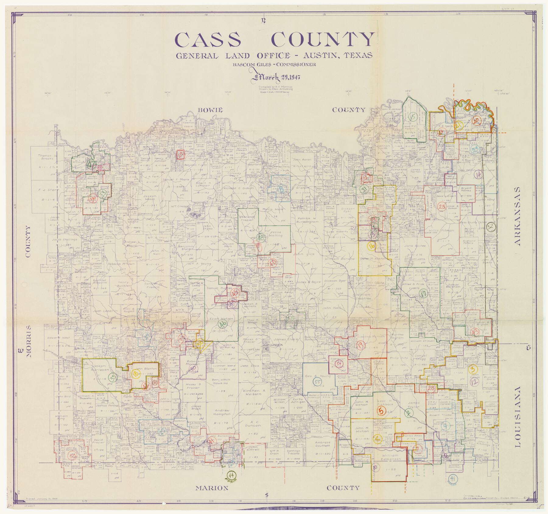
Cass County Working Sketch Graphic Index
-
Map/Doc
76489
-
Collection
General Map Collection
-
Object Dates
3/29/1947 (Creation Date)
-
People and Organizations
G.C. Morriss (Compiler)
Eltea Armstrong (Draftsman)
-
Counties
Cass
-
Subjects
County Surveying Working Sketch
-
Height x Width
39.1 x 41.9 inches
99.3 x 106.4 cm
-
Scale
1" = 2000 varas
-
Comments
Please note that Cass County Working Sketch 49 is missing and therefore no longer available.
Part of: General Map Collection
Midland County Working Sketch 30

Print $20.00
- Digital $50.00
Midland County Working Sketch 30
1971
Size 45.1 x 35.4 inches
Map/Doc 71011
Cameron County Rolled Sketch 25

Print $20.00
- Digital $50.00
Cameron County Rolled Sketch 25
1977
Size 24.5 x 30.4 inches
Map/Doc 5793
Sabine Bank to East Bay including Heald Bank

Print $20.00
- Digital $50.00
Sabine Bank to East Bay including Heald Bank
1960
Size 45.1 x 34.3 inches
Map/Doc 69847
Val Verde County Sketch File A

Print $20.00
- Digital $50.00
Val Verde County Sketch File A
1878
Size 25.6 x 16.0 inches
Map/Doc 12538
Foard County Working Sketch 15

Print $40.00
- Digital $50.00
Foard County Working Sketch 15
1982
Size 43.7 x 76.0 inches
Map/Doc 69206
Jeff Davis County Working Sketch 10

Print $20.00
- Digital $50.00
Jeff Davis County Working Sketch 10
1946
Size 29.3 x 37.0 inches
Map/Doc 66505

Gregg County Rolled Sketch 11

Print $20.00
- Digital $50.00
Gregg County Rolled Sketch 11
Size 32.7 x 30.5 inches
Map/Doc 6036
Galveston County Rolled Sketch 13

Print $20.00
- Digital $50.00
Galveston County Rolled Sketch 13
1890
Size 34.5 x 24.2 inches
Map/Doc 5953

Montague County Sketch File 24

Print $20.00
- Digital $50.00
Montague County Sketch File 24
1941
Size 16.2 x 23.3 inches
Map/Doc 12108
Rockwall County Sketch File 4

Print $9.00
Rockwall County Sketch File 4
1860
Size 7.7 x 12.1 inches
Map/Doc 35419
You may also like
McCulloch County Boundary File 2

Print $6.00
- Digital $50.00
McCulloch County Boundary File 2
Size 12.9 x 8.3 inches
Map/Doc 56908
Karte des Staates, Texas

Print $20.00
- Digital $50.00
Karte des Staates, Texas
1851
Size 25.5 x 30.8 inches
Map/Doc 2123
Midland County

Print $20.00
- Digital $50.00
Midland County
1930
Size 45.9 x 39.5 inches
Map/Doc 95589
Collingsworth County Sketch File 8

Print $4.00
- Digital $50.00
Collingsworth County Sketch File 8
Size 7.4 x 11.6 inches
Map/Doc 18889
Sterling County Rolled Sketch 38

Print $20.00
- Digital $50.00
Sterling County Rolled Sketch 38
1988
Size 25.0 x 31.7 inches
Map/Doc 7863
Concho County Sketch File 25

Print $8.00
- Digital $50.00
Concho County Sketch File 25
1885
Size 11.4 x 9.0 inches
Map/Doc 19155
Working Sketch Cochran and Yoakum Co's.

Print $40.00
- Digital $50.00
Working Sketch Cochran and Yoakum Co's.
1919
Size 54.2 x 14.5 inches
Map/Doc 89678
General Highway Map. Detail of Cities and Towns in Williamson County, Texas [Round Rock, Taylor, Georgetown]
![79714, General Highway Map. Detail of Cities and Towns in Williamson County, Texas [Round Rock, Taylor, Georgetown], Texas State Library and Archives](https://historictexasmaps.com/wmedia_w700/maps/79714.tif.jpg)
Print $20.00
General Highway Map. Detail of Cities and Towns in Williamson County, Texas [Round Rock, Taylor, Georgetown]
1961
Size 18.2 x 24.8 inches
Map/Doc 79714
![91463, [Block B7], Twichell Survey Records](https://historictexasmaps.com/wmedia_w700/maps/91463-1.tif.jpg)
Harris County Sketch File 31a

Print $20.00
- Digital $50.00
Harris County Sketch File 31a
1895
Size 12.8 x 21.9 inches
Map/Doc 11650
Runnels County Boundary File 1b

Print $24.00
- Digital $50.00
Runnels County Boundary File 1b
Size 15.7 x 8.3 inches
Map/Doc 58514
Sabine River, Toll Bridge Sheet

Print $40.00
- Digital $50.00
Sabine River, Toll Bridge Sheet
1933
Size 27.8 x 51.9 inches
Map/Doc 65136