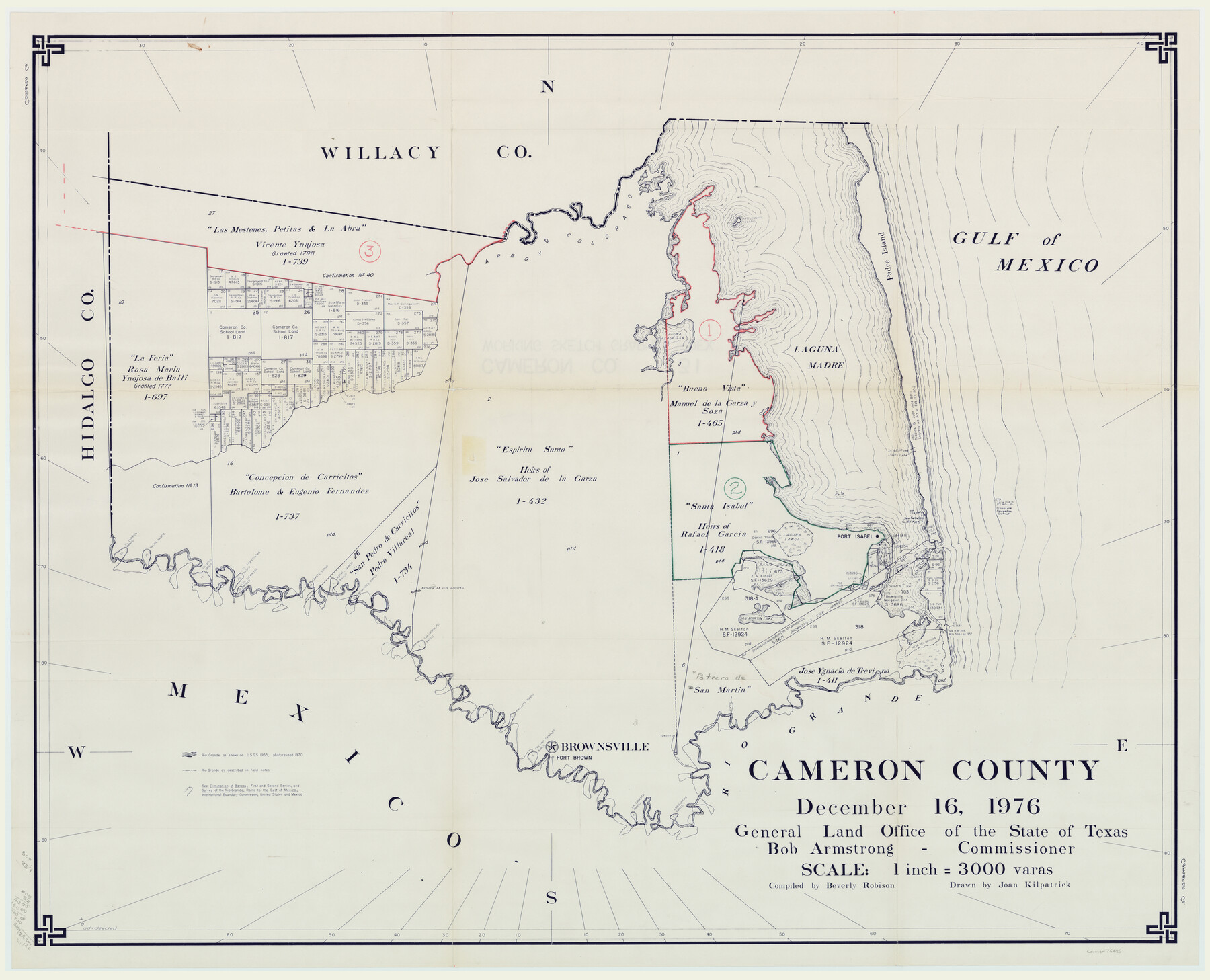
Cameron County Working Sketch Graphic Index
-
Map/Doc
76486
-
Collection
General Map Collection
-
Object Dates
12/16/1976 (Creation Date)
-
People and Organizations
Beverly Robison (Compiler)
Joan Kilpatrick (Draftsman)
-
Counties
Cameron
-
Subjects
County Surveying Working Sketch
-
Height x Width
32.0 x 39.4 inches
81.3 x 100.1 cm
-
Scale
1" = 3000 varas
Part of: General Map Collection
Smith County Working Sketch 11

Print $20.00
- Digital $50.00
Smith County Working Sketch 11
1960
Size 18.6 x 21.6 inches
Map/Doc 63896
Hardin County Sketch File 68

Print $20.00
- Digital $50.00
Hardin County Sketch File 68
1948
Size 23.9 x 21.4 inches
Map/Doc 11640

Kenedy County Rolled Sketch 10

Print $20.00
- Digital $50.00
Kenedy County Rolled Sketch 10
1915
Size 21.7 x 35.7 inches
Map/Doc 6470
Midland County Boundary File 3

Print $4.00
- Digital $50.00
Midland County Boundary File 3
Size 8.2 x 8.3 inches
Map/Doc 57174
Flight Mission No. DIX-8P, Frame 61, Aransas County

Print $20.00
- Digital $50.00
Flight Mission No. DIX-8P, Frame 61, Aransas County
1956
Size 18.8 x 22.6 inches
Map/Doc 83892
Parker County Sketch File 46

Print $26.00
- Digital $50.00
Parker County Sketch File 46
1957
Size 11.2 x 8.5 inches
Map/Doc 33615
Duval County Sketch File 85

Print $27.00
- Digital $50.00
Duval County Sketch File 85
1935
Size 14.3 x 9.1 inches
Map/Doc 21534
La Salle County Rolled Sketch 3

Print $20.00
- Digital $50.00
La Salle County Rolled Sketch 3
1937
Size 32.6 x 38.9 inches
Map/Doc 6568
Flight Mission No. BQR-7K, Frame 32, Brazoria County

Print $20.00
- Digital $50.00
Flight Mission No. BQR-7K, Frame 32, Brazoria County
1952
Size 18.6 x 22.2 inches
Map/Doc 84030
Topographical Map of the Rio Grande, Sheet No. 2

Print $20.00
- Digital $50.00
Topographical Map of the Rio Grande, Sheet No. 2
1912
Map/Doc 89526
Val Verde County Sketch File 51a

Print $8.00
- Digital $50.00
Val Verde County Sketch File 51a
1959
Size 11.4 x 8.8 inches
Map/Doc 39325
You may also like
General Highway Map, Liberty County, Texas

Print $20.00
General Highway Map, Liberty County, Texas
1961
Size 18.1 x 24.6 inches
Map/Doc 79571
Upton County Sketch File 19

Print $20.00
- Digital $50.00
Upton County Sketch File 19
1927
Size 21.2 x 21.4 inches
Map/Doc 12515
Map of Sabine County

Print $20.00
- Digital $50.00
Map of Sabine County
1896
Size 26.6 x 19.3 inches
Map/Doc 4010
Working Sketch Cottle County

Print $20.00
- Digital $50.00
Working Sketch Cottle County
1916
Size 31.7 x 29.6 inches
Map/Doc 4434
[Galveston, Harrisburg & San Antonio Railway]
![64408, [Galveston, Harrisburg & San Antonio Railway], General Map Collection](https://historictexasmaps.com/wmedia_w700/maps/64408.tif.jpg)
Print $20.00
- Digital $50.00
[Galveston, Harrisburg & San Antonio Railway]
1892
Size 13.5 x 33.6 inches
Map/Doc 64408
Menard County Working Sketch 3

Print $20.00
- Digital $50.00
Menard County Working Sketch 3
1913
Size 15.2 x 13.2 inches
Map/Doc 70950
A Map of Texas Showing the State Parks and the Municipal Parks

Print $20.00
A Map of Texas Showing the State Parks and the Municipal Parks
1936
Size 34.8 x 37.5 inches
Map/Doc 76311
Map of Glasscock County

Print $20.00
- Digital $50.00
Map of Glasscock County
Size 18.8 x 25.1 inches
Map/Doc 90783
San Saba County Sketch File 17

Print $8.00
- Digital $50.00
San Saba County Sketch File 17
1918
Size 11.4 x 8.8 inches
Map/Doc 36456
Houston County

Print $40.00
- Digital $50.00
Houston County
1944
Size 48.3 x 49.7 inches
Map/Doc 1859
Flight Mission No. DCL-6C, Frame 112, Kenedy County

Print $20.00
- Digital $50.00
Flight Mission No. DCL-6C, Frame 112, Kenedy County
1943
Size 15.4 x 15.5 inches
Map/Doc 85942
Navarro County Working Sketch 14

Print $20.00
- Digital $50.00
Navarro County Working Sketch 14
1981
Size 36.8 x 33.1 inches
Map/Doc 71244