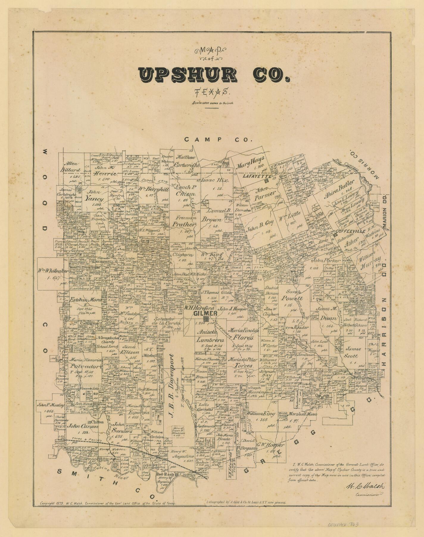
Map of Upshur County, Texas
-
Map/Doc
763
-
Collection
Maddox Collection
-
Object Dates
1879 (Creation Date)
-
People and Organizations
General Land Office (Publisher)
W.C. Walsh (GLO Commissioner)
August Gast & Co. (Lithographer)
-
Counties
Upshur
-
Subjects
County
-
Height x Width
21.5 x 17.5 inches
54.6 x 44.5 cm
-
Medium
paper, etching/engraving/lithograph
-
Scale
1" = 4000 varas
-
Comments
Conservation funded in 2011.
-
Features
Gilmer
Sabine River
Red Rock
Big Sandy Creek
T&P
Chilton
Little White Oak Creek
Glade's Creek
Omega
Glad Creek
Glade or Prairie Creek
Hog Creek
Calloway
Kelsey Creek
Little Cypress Creek
Clear Creek
South Fork of Lilly Creek
Bear Creek
Gum Creek
Gum or Bear Creek
Walnut Creek
Mud Creek
Cypress Creek
Caney Creek
Prairie Creek
Lilly Creek
Coffeeville
Big Cypress Creek
Richland Creek
Lafayette
[] Fork of Lilly Creek
Part of: Maddox Collection
Map of Denton County, Texas

Print $20.00
- Digital $50.00
Map of Denton County, Texas
Size 22.8 x 19.4 inches
Map/Doc 711
Map of Duval County, Texas

Print $20.00
- Digital $50.00
Map of Duval County, Texas
1880
Size 29.8 x 22.6 inches
Map/Doc 712
[Littlefield & White Survey, Kimble County, Texas]
![570, [Littlefield & White Survey, Kimble County, Texas], Maddox Collection](https://historictexasmaps.com/wmedia_w700/maps/0570.tif.jpg)
Print $20.00
- Digital $50.00
[Littlefield & White Survey, Kimble County, Texas]
Size 18.6 x 14.2 inches
Map/Doc 570
[Kenney's sketch of the surveys in Dickens and Motley Counties]

Print $20.00
- Digital $50.00
[Kenney's sketch of the surveys in Dickens and Motley Counties]
1905
Size 20.1 x 15.7 inches
Map/Doc 367
[CTRR Co. Block T, Cottle County, Texas]
![10777, [CTRR Co. Block T, Cottle County, Texas], Maddox Collection](https://historictexasmaps.com/wmedia_w700/maps/10777.tif.jpg)
Print $20.00
- Digital $50.00
[CTRR Co. Block T, Cottle County, Texas]
Size 21.5 x 14.0 inches
Map/Doc 10777
Map of Lavaca County, Texas

Print $20.00
- Digital $50.00
Map of Lavaca County, Texas
1879
Size 22.8 x 25.0 inches
Map/Doc 561
Revised Sectional Map No. 6 showing land surveys in parts of Presidio and Brewster Counties, Texas

Print $20.00
- Digital $50.00
Revised Sectional Map No. 6 showing land surveys in parts of Presidio and Brewster Counties, Texas
Size 24.2 x 23.0 inches
Map/Doc 4475
Sketch of Garza Co.

Print $3.00
- Digital $50.00
Sketch of Garza Co.
1884
Size 12.3 x 10.2 inches
Map/Doc 468
Borden County, Texas

Print $20.00
- Digital $50.00
Borden County, Texas
1892
Size 25.7 x 20.9 inches
Map/Doc 394
[Plat Showing Colorado, Upshur & Travis County School Land and Surrounding Area in Baylor & Throckmorton Counties, Texas]
![75790, [Plat Showing Colorado, Upshur & Travis County School Land and Surrounding Area in Baylor & Throckmorton Counties, Texas], Maddox Collection](https://historictexasmaps.com/wmedia_w700/maps/75790.tif.jpg)
Print $20.00
- Digital $50.00
[Plat Showing Colorado, Upshur & Travis County School Land and Surrounding Area in Baylor & Throckmorton Counties, Texas]
1889
Size 15.8 x 20.5 inches
Map/Doc 75790
Map of Nacogdoches County, Texas

Print $20.00
- Digital $50.00
Map of Nacogdoches County, Texas
1881
Size 24.6 x 21.1 inches
Map/Doc 585
Survey of Lots 1, 2, 3, 4 and 5, Block 12G Fair View Park, Austin Texas

Print $20.00
- Digital $50.00
Survey of Lots 1, 2, 3, 4 and 5, Block 12G Fair View Park, Austin Texas
1914
Size 23.1 x 11.0 inches
Map/Doc 83431
You may also like
Flight Mission No. CGI-3N, Frame 127, Cameron County

Print $20.00
- Digital $50.00
Flight Mission No. CGI-3N, Frame 127, Cameron County
1954
Size 18.8 x 22.4 inches
Map/Doc 84600
Taylor County, Texas

Print $20.00
- Digital $50.00
Taylor County, Texas
1890
Size 28.7 x 21.6 inches
Map/Doc 574
Capitol Grounds, Austin

Print $20.00
- Digital $50.00
Capitol Grounds, Austin
Size 35.4 x 40.5 inches
Map/Doc 16955
Mapa de la Sierra Gorda y costa del Seno Mexicano desde la ciudad de Querétaro hasta la Bahía del Espíritu Santo, sus rios, ensenadas y provincias pacificadas por Don José de Escandón

Print $20.00
Mapa de la Sierra Gorda y costa del Seno Mexicano desde la ciudad de Querétaro hasta la Bahía del Espíritu Santo, sus rios, ensenadas y provincias pacificadas por Don José de Escandón
1792
Size 21.4 x 16.8 inches
Map/Doc 89047
Map of the United States and Texas Boundary Line and adjacent territory determined & surveyed in 1857-8-9-60 by J.H. Clark, U.S. Commissioner, &ca. &ca. under the direction of the Departement [sic] of the Interior
![94063, Map of the United States and Texas Boundary Line and adjacent territory determined & surveyed in 1857-8-9-60 by J.H. Clark, U.S. Commissioner, &ca. &ca. under the direction of the Departement [sic] of the Interior, General Map Collection](https://historictexasmaps.com/wmedia_w700/maps/94063.tif.jpg)
Print $20.00
- Digital $50.00
Map of the United States and Texas Boundary Line and adjacent territory determined & surveyed in 1857-8-9-60 by J.H. Clark, U.S. Commissioner, &ca. &ca. under the direction of the Departement [sic] of the Interior
1902
Size 27.9 x 41.8 inches
Map/Doc 94063
Anderson County Sketch File 16b

Print $2.00
- Digital $50.00
Anderson County Sketch File 16b
1859
Size 7.2 x 2.9 inches
Map/Doc 12788
Map of Jack County

Print $20.00
- Digital $50.00
Map of Jack County
Size 18.7 x 15.9 inches
Map/Doc 3703
Principal Highways of the Southwest with particular reference to New Mexico, Oklahoma, Texas, Arkansas and Louisiana

Print $20.00
Principal Highways of the Southwest with particular reference to New Mexico, Oklahoma, Texas, Arkansas and Louisiana
1933
Size 24.3 x 18.4 inches
Map/Doc 76302
Archer County Boundary File 6

Print $62.00
- Digital $50.00
Archer County Boundary File 6
Size 22.5 x 6.1 inches
Map/Doc 50113
Lake Austin, Travis County, Texas

Print $20.00
- Digital $50.00
Lake Austin, Travis County, Texas
1937
Size 24.8 x 16.4 inches
Map/Doc 2056
Flight Mission No. BRA-17M, Frame 15, Jefferson County

Print $20.00
- Digital $50.00
Flight Mission No. BRA-17M, Frame 15, Jefferson County
1953
Size 18.5 x 22.3 inches
Map/Doc 85796
Map of the State of Texas Engraved to Illustrate Mitchell's School and Family Geography

Print $20.00
Map of the State of Texas Engraved to Illustrate Mitchell's School and Family Geography
1846
Size 12.0 x 9.6 inches
Map/Doc 87902