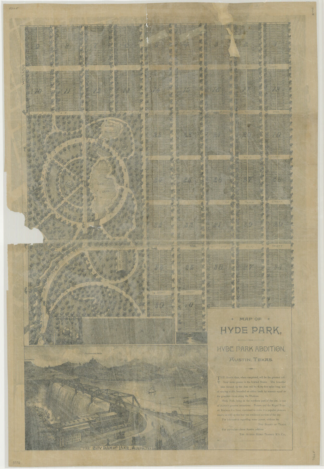
Map of Hyde Park
-
Map/Doc
76206
-
Collection
Texas State Library and Archives
-
Object Dates
[1895] (Creation Date)
-
People and Organizations
Augustus Koch (Compiler)
-
Counties
Travis
-
Subjects
Bird's Eye View City Pictorial
-
Height x Width
41.7 x 28.8 inches
105.9 x 73.2 cm
-
Comments
Prints available courtesy of the Texas State Library and Archives.
More info can be found here: TSLAC Map 00926e
Related maps
Partial View of Austin, Texas

Print $20.00
Partial View of Austin, Texas
1895
Size 28.4 x 41.8 inches
Map/Doc 76205
Part of: Texas State Library and Archives
General Highway Map, Marion County, Texas

Print $20.00
General Highway Map, Marion County, Texas
1940
Size 18.3 x 24.7 inches
Map/Doc 79184
General Highway Map, Cameron County, Texas

Print $20.00
General Highway Map, Cameron County, Texas
1961
Size 18.3 x 24.7 inches
Map/Doc 79397
General Highway Map, Motley County, Texas

Print $20.00
General Highway Map, Motley County, Texas
1961
Size 24.7 x 18.1 inches
Map/Doc 79605
General Highway Map, Cass County, Texas

Print $20.00
General Highway Map, Cass County, Texas
1940
Size 18.6 x 25.2 inches
Map/Doc 79042
General Highway Map. Detail of Cities and Towns in Tarrant County, Texas [Fort Worth and vicinity]
![79252, General Highway Map. Detail of Cities and Towns in Tarrant County, Texas [Fort Worth and vicinity], Texas State Library and Archives](https://historictexasmaps.com/wmedia_w700/maps/79252-GC.tif.jpg)
Print $20.00
General Highway Map. Detail of Cities and Towns in Tarrant County, Texas [Fort Worth and vicinity]
1940
Size 24.9 x 18.2 inches
Map/Doc 79252
General Highway Map. Detail of Cities and Towns in Falls County, Texas

Print $20.00
General Highway Map. Detail of Cities and Towns in Falls County, Texas
1961
Size 18.1 x 24.4 inches
Map/Doc 79463
General Highway Map, Ward County, Texas

Print $20.00
General Highway Map, Ward County, Texas
1940
Size 18.5 x 25.1 inches
Map/Doc 79271
General Highway Map, Borden County, Texas

Print $20.00
General Highway Map, Borden County, Texas
1961
Size 18.3 x 25.0 inches
Map/Doc 79377
General Highway Map, Reeves County, Texas

Print $20.00
General Highway Map, Reeves County, Texas
1940
Size 24.8 x 18.2 inches
Map/Doc 79227
General Highway Map, Oldham County, Texas

Print $20.00
General Highway Map, Oldham County, Texas
1961
Size 24.6 x 18.2 inches
Map/Doc 79620
General Highway Map, Live Oak County, Texas

Print $20.00
General Highway Map, Live Oak County, Texas
1940
Size 18.4 x 24.8 inches
Map/Doc 79177
General Highway Map. Detail of Cities and Towns in Tarrant County, Texas. City Map, Fort Worth and vicinity, Tarrant County, Texas

Print $20.00
General Highway Map. Detail of Cities and Towns in Tarrant County, Texas. City Map, Fort Worth and vicinity, Tarrant County, Texas
1961
Size 18.2 x 25.0 inches
Map/Doc 79670
You may also like
[Galveston, Harrisburg & San Antonio Railway]
![64404, [Galveston, Harrisburg & San Antonio Railway], General Map Collection](https://historictexasmaps.com/wmedia_w700/maps/64404.tif.jpg)
Print $20.00
- Digital $50.00
[Galveston, Harrisburg & San Antonio Railway]
1892
Size 13.8 x 34.0 inches
Map/Doc 64404
Potter County Boundary File 4

Print $30.00
- Digital $50.00
Potter County Boundary File 4
Size 14.6 x 9.3 inches
Map/Doc 57997
Flight Mission No. CGI-3N, Frame 167, Cameron County

Print $20.00
- Digital $50.00
Flight Mission No. CGI-3N, Frame 167, Cameron County
1954
Size 18.6 x 22.4 inches
Map/Doc 84631
Kaufman County Working Sketch 7

Print $6.00
- Digital $50.00
Kaufman County Working Sketch 7
1984
Size 33.6 x 35.5 inches
Map/Doc 66670
[State of Texas]
![92061, [State of Texas], Twichell Survey Records](https://historictexasmaps.com/wmedia_w700/maps/92061-1.tif.jpg)
Print $20.00
- Digital $50.00
[State of Texas]
Size 13.7 x 13.7 inches
Map/Doc 92061
Gregg County Boundary File 9

Print $16.00
- Digital $50.00
Gregg County Boundary File 9
Size 4.1 x 14.9 inches
Map/Doc 54023
Fayette County Boundary File 2

Print $53.00
- Digital $50.00
Fayette County Boundary File 2
Size 11.2 x 9.0 inches
Map/Doc 53331
Waller County Working Sketch 5

Print $20.00
- Digital $50.00
Waller County Working Sketch 5
1966
Size 23.1 x 27.1 inches
Map/Doc 72304
Current Miscellaneous File 94

Print $3.00
- Digital $50.00
Current Miscellaneous File 94
1851
Size 11.2 x 17.1 inches
Map/Doc 74268
Briscoe County Sketch File 3

Print $40.00
- Digital $50.00
Briscoe County Sketch File 3
1885
Size 22.6 x 20.7 inches
Map/Doc 10992
Township No. 2 South Range No. 22 West of the Indian Meridian

Print $20.00
- Digital $50.00
Township No. 2 South Range No. 22 West of the Indian Meridian
1875
Size 19.2 x 24.3 inches
Map/Doc 75176
Nolan County Working Sketch 7

Print $20.00
- Digital $50.00
Nolan County Working Sketch 7
1954
Size 33.9 x 24.3 inches
Map/Doc 71298