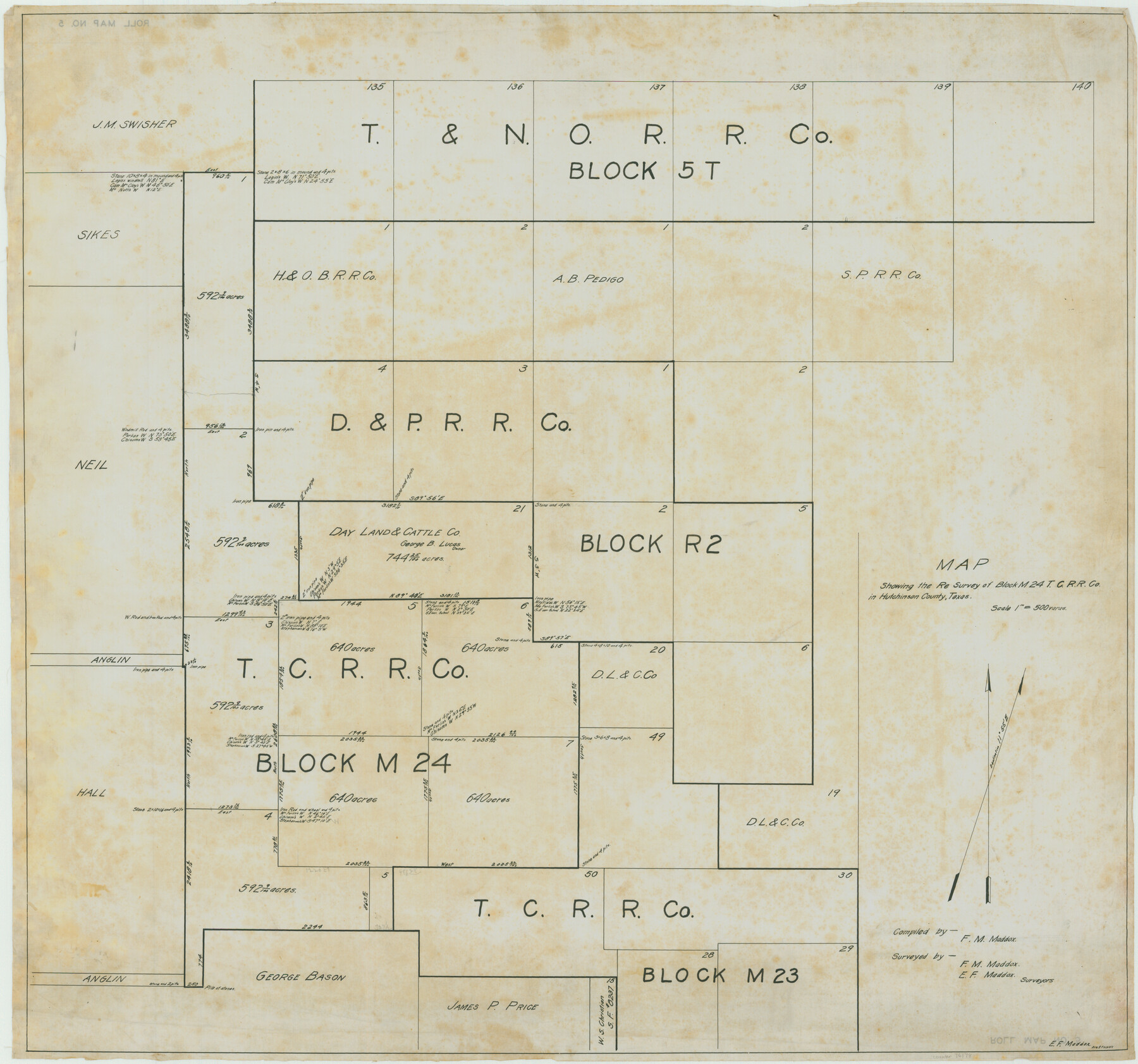
Map showing the resurvey of Block M24 T. C. R.R. Co. in Hutchinson County, Texas
Roll Map No. 5.
-
Map/Doc
76178
-
Collection
Maddox Collection
-
People and Organizations
E.F. Maddox (Draftsman)
F.M. Maddox (Compiler)
E.F. Maddox (Surveyor/Engineer)
F.M. Maddox (Surveyor/Engineer)
-
Counties
Hutchinson
-
Height x Width
28.8 x 30.8 inches
73.2 x 78.2 cm
-
Medium
paper, manuscript
-
Scale
1" = 500 varas
Part of: Maddox Collection
[Plat Showing Jeremiah Kirby, Champion Choat, A. M. Lejarza & Hardin Co. School Lands]
![5040, [Plat Showing Jeremiah Kirby, Champion Choat, A. M. Lejarza & Hardin Co. School Lands], Maddox Collection](https://historictexasmaps.com/wmedia_w700/maps/5040.tif.jpg)
Print $20.00
- Digital $50.00
[Plat Showing Jeremiah Kirby, Champion Choat, A. M. Lejarza & Hardin Co. School Lands]
Size 28.8 x 38.9 inches
Map/Doc 5040
Austin, Texas - Congress Ave. Drainage

Print $20.00
- Digital $50.00
Austin, Texas - Congress Ave. Drainage
1905
Size 15.8 x 31.2 inches
Map/Doc 458
Map of Kimble County, Texas

Print $20.00
- Digital $50.00
Map of Kimble County, Texas
1879
Size 18.1 x 28.3 inches
Map/Doc 527
[Sketch of Surveys in] Tom Green County, [Texas]
![471, [Sketch of Surveys in] Tom Green County, [Texas]](https://historictexasmaps.com/wmedia_w700/maps/0471.tif.jpg)
Print $20.00
- Digital $50.00
[Sketch of Surveys in] Tom Green County, [Texas]
1882
Size 14.1 x 20.3 inches
Map/Doc 471
Plat of Surveys in Hidalgo Co.

Print $20.00
- Digital $50.00
Plat of Surveys in Hidalgo Co.
Size 18.3 x 9.2 inches
Map/Doc 75548
Map of Surveys 6, 7, & 8, Block 1, D.B. Gardner 7 1/2, Block L, D.B. Gardner 7, Block T, J.P. Goen

Print $20.00
- Digital $50.00
Map of Surveys 6, 7, & 8, Block 1, D.B. Gardner 7 1/2, Block L, D.B. Gardner 7, Block T, J.P. Goen
1917
Size 11.0 x 22.6 inches
Map/Doc 10762
Map of Duval County, Texas

Print $20.00
- Digital $50.00
Map of Duval County, Texas
1880
Size 31.4 x 21.8 inches
Map/Doc 5030
[Block A, Greer County, Texas]
![384, [Block A, Greer County, Texas], Maddox Collection](https://historictexasmaps.com/wmedia_w700/maps/384.tif.jpg)
Print $20.00
- Digital $50.00
[Block A, Greer County, Texas]
Size 16.9 x 15.8 inches
Map/Doc 384
[Mary L. Williams or Lydia Glasgow Survey, Bastrop County, Texas]
![572, [Mary L. Williams or Lydia Glasgow Survey, Bastrop County, Texas], Maddox Collection](https://historictexasmaps.com/wmedia_w700/maps/0572-1.tif.jpg)
Print $3.00
- Digital $50.00
[Mary L. Williams or Lydia Glasgow Survey, Bastrop County, Texas]
Size 11.9 x 15.6 inches
Map/Doc 572
[Sketch Showing Surveys Adjacent to Richmond, Fort Bend County, Texas]
![395, [Sketch Showing Surveys Adjacent to Richmond, Fort Bend County, Texas], Maddox Collection](https://historictexasmaps.com/wmedia_w700/maps/0395.tif.jpg)
Print $2.00
- Digital $50.00
[Sketch Showing Surveys Adjacent to Richmond, Fort Bend County, Texas]
Size 9.9 x 7.7 inches
Map/Doc 395
Official Copy of the Map of Milam County made for the International and G. N. R. R. Co.

Print $20.00
- Digital $50.00
Official Copy of the Map of Milam County made for the International and G. N. R. R. Co.
1877
Size 23.9 x 22.5 inches
Map/Doc 581
Midland County, Texas

Print $20.00
- Digital $50.00
Midland County, Texas
1880
Size 25.5 x 21.5 inches
Map/Doc 740
You may also like
Travis County Working Sketch 57

Print $20.00
- Digital $50.00
Travis County Working Sketch 57
1989
Size 42.8 x 44.0 inches
Map/Doc 69441
Delta County, Texas

Print $20.00
- Digital $50.00
Delta County, Texas
1884
Size 14.1 x 20.0 inches
Map/Doc 416
Andrews County Working Sketch 25

Print $40.00
- Digital $50.00
Andrews County Working Sketch 25
1980
Size 70.6 x 44.0 inches
Map/Doc 67071
Wilbarger County Sketch File 4

Print $4.00
- Digital $50.00
Wilbarger County Sketch File 4
1883
Size 12.7 x 8.2 inches
Map/Doc 40168
[Blocks D3, A, D7, and RG]
![92764, [Blocks D3, A, D7, and RG], Twichell Survey Records](https://historictexasmaps.com/wmedia_w700/maps/92764-1.tif.jpg)
Print $20.00
- Digital $50.00
[Blocks D3, A, D7, and RG]
Size 36.7 x 31.1 inches
Map/Doc 92764
Nacogdoches County Sketch File 11

Print $2.00
- Digital $50.00
Nacogdoches County Sketch File 11
Size 8.0 x 8.8 inches
Map/Doc 32255
Calhoun County Rolled Sketch 28A

Print $20.00
- Digital $50.00
Calhoun County Rolled Sketch 28A
1834
Size 23.1 x 33.1 inches
Map/Doc 5375
Map of Haskell County Young District

Print $20.00
- Digital $50.00
Map of Haskell County Young District
1859
Size 21.9 x 25.8 inches
Map/Doc 3641
Uvalde County Working Sketch 34

Print $20.00
- Digital $50.00
Uvalde County Working Sketch 34
1963
Size 31.6 x 42.8 inches
Map/Doc 72104
Hopkins County Sketch File 16a

Print $4.00
- Digital $50.00
Hopkins County Sketch File 16a
Size 12.1 x 7.6 inches
Map/Doc 26715
Calhoun County Rolled Sketch 6

Print $20.00
- Digital $50.00
Calhoun County Rolled Sketch 6
Size 24.0 x 22.5 inches
Map/Doc 5362
Terrell County Sketch File 25

Print $4.00
- Digital $50.00
Terrell County Sketch File 25
1935
Size 13.5 x 8.1 inches
Map/Doc 37959