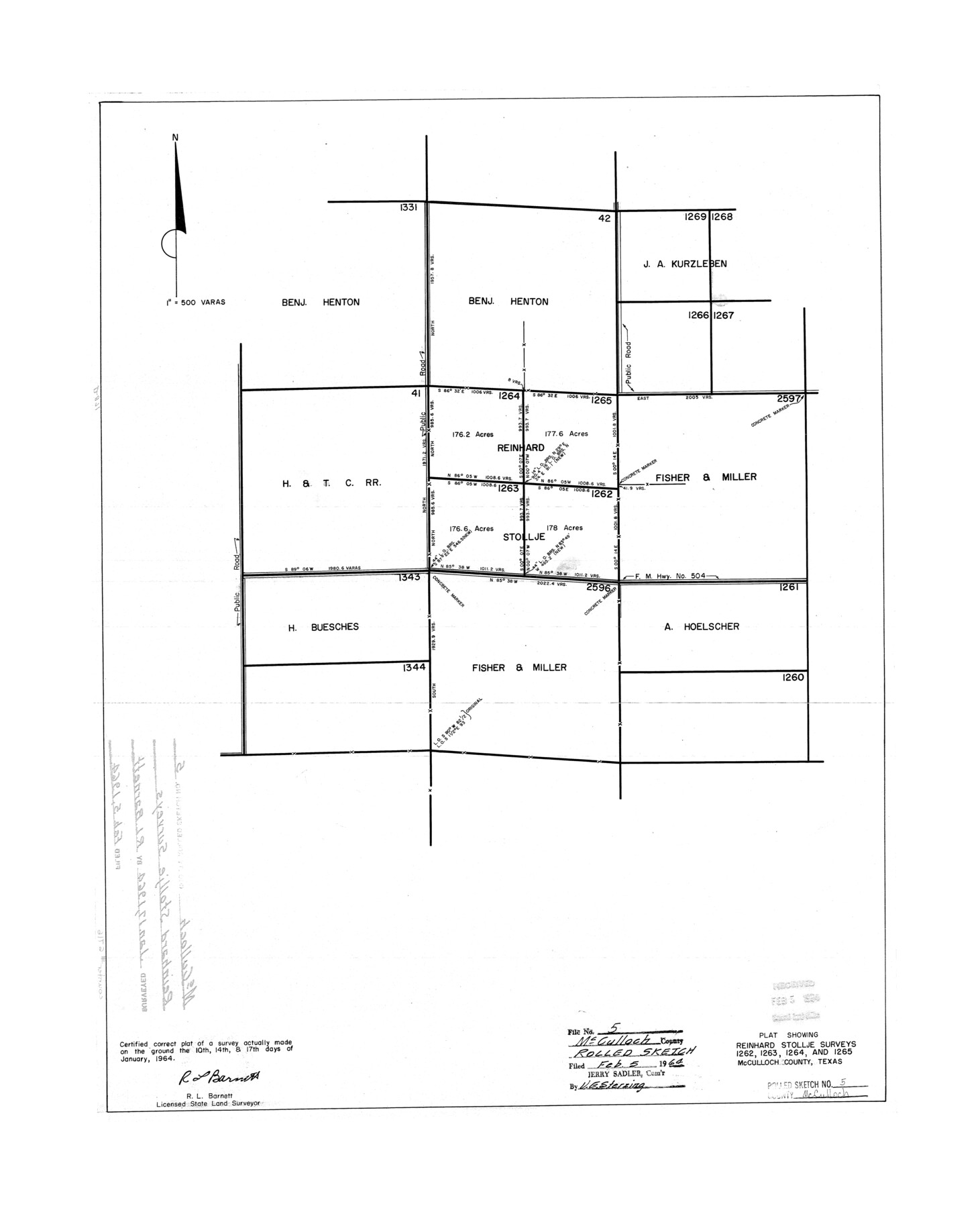
McCulloch County Rolled Sketch 5
Plat showing Reinhard Stollje surveys 1262, 1263, 1264, and 1265, McCulloch County, Texas
-
Map/Doc
6716
-
Collection
General Map Collection
-
Object Dates
1964/1/17 (Survey Date)
1964/2/5 (File Date)
-
People and Organizations
R.L. Barnett (Surveyor/Engineer)
-
Counties
McCulloch
-
Subjects
Surveying Rolled Sketch
-
Height x Width
25.7 x 20.9 inches
65.3 x 53.1 cm
-
Scale
1" = 500 varas
Part of: General Map Collection

Reagan County Rolled Sketch 35

Print $20.00
- Digital $50.00
Reagan County Rolled Sketch 35
Size 26.4 x 38.4 inches
Map/Doc 7448
Flight Mission No. DQN-2K, Frame 85, Calhoun County

Print $20.00
- Digital $50.00
Flight Mission No. DQN-2K, Frame 85, Calhoun County
1953
Size 18.8 x 22.4 inches
Map/Doc 84275
Val Verde County Sketch File 4

Print $30.00
- Digital $50.00
Val Verde County Sketch File 4
1888
Size 28.0 x 20.6 inches
Map/Doc 12561
Coleman County Sketch File 44

Print $17.00
- Digital $50.00
Coleman County Sketch File 44
Size 14.1 x 8.6 inches
Map/Doc 18783
Wilbarger County Sketch File 29

Print $18.00
- Digital $50.00
Wilbarger County Sketch File 29
2016
Size 11.0 x 8.5 inches
Map/Doc 95325
Blanco County Sketch File 51

Print $8.00
- Digital $50.00
Blanco County Sketch File 51
1998
Size 11.1 x 8.5 inches
Map/Doc 14697
Roseborough Lake Sheet, Bowie County, Red River

Print $20.00
- Digital $50.00
Roseborough Lake Sheet, Bowie County, Red River
1934
Size 39.5 x 23.0 inches
Map/Doc 75273
Wood County Working Sketch Graphic Index

Print $20.00
- Digital $50.00
Wood County Working Sketch Graphic Index
1942
Size 40.6 x 36.4 inches
Map/Doc 76746
Flight Mission No. BRA-6M, Frame 81, Jefferson County

Print $20.00
- Digital $50.00
Flight Mission No. BRA-6M, Frame 81, Jefferson County
1953
Size 18.6 x 22.6 inches
Map/Doc 85425
Duval County Working Sketch 2

Print $20.00
- Digital $50.00
Duval County Working Sketch 2
1919
Size 16.4 x 15.0 inches
Map/Doc 76443

You may also like
Upton County Working Sketch 58

Print $20.00
- Digital $50.00
Upton County Working Sketch 58
1988
Size 29.1 x 37.8 inches
Map/Doc 69555
Garza County Working Sketch 3

Print $20.00
- Digital $50.00
Garza County Working Sketch 3
1919
Size 13.8 x 14.0 inches
Map/Doc 63150
Foard County Working Sketch 15

Print $40.00
- Digital $50.00
Foard County Working Sketch 15
1982
Size 43.7 x 76.0 inches
Map/Doc 69206
Sectional Map No. 3 of the lands and of the line of the Texas & Pacific Ry. Co. in Reeves and parts of Tom Green, Pecos, Presidio & El Paso Cos.

Print $20.00
- Digital $50.00
Sectional Map No. 3 of the lands and of the line of the Texas & Pacific Ry. Co. in Reeves and parts of Tom Green, Pecos, Presidio & El Paso Cos.
1885
Size 22.3 x 17.4 inches
Map/Doc 2303
Starr County Working Sketch Graphic Index

Print $40.00
- Digital $50.00
Starr County Working Sketch Graphic Index
1977
Size 43.0 x 55.5 inches
Map/Doc 76701
Flight Mission No. DIX-10P, Frame 68, Aransas County

Print $20.00
- Digital $50.00
Flight Mission No. DIX-10P, Frame 68, Aransas County
1956
Size 18.9 x 22.5 inches
Map/Doc 83929
Crockett County Rolled Sketch 81

Print $20.00
- Digital $50.00
Crockett County Rolled Sketch 81
1958
Size 20.6 x 24.5 inches
Map/Doc 5621
[G. B. & C. Blocks K3 and K4]
![90512, [G. B. & C. Blocks K3 and K4], Twichell Survey Records](https://historictexasmaps.com/wmedia_w700/maps/90512-1.tif.jpg)
Print $20.00
- Digital $50.00
[G. B. & C. Blocks K3 and K4]
Size 14.0 x 14.5 inches
Map/Doc 90512
Flight Mission No. DIX-3P, Frame 170, Aransas County

Print $20.00
- Digital $50.00
Flight Mission No. DIX-3P, Frame 170, Aransas County
1956
Size 17.8 x 18.2 inches
Map/Doc 83776
Hays County State Real Property Sketch 3

Print $20.00
- Digital $50.00
Hays County State Real Property Sketch 3
2003
Size 24.0 x 37.2 inches
Map/Doc 96638
Flight Mission No. BRA-6M, Frame 75, Jefferson County

Print $20.00
- Digital $50.00
Flight Mission No. BRA-6M, Frame 75, Jefferson County
1953
Size 18.8 x 22.5 inches
Map/Doc 85419
Jim Hogg County Rolled Sketch 3

Print $20.00
- Digital $50.00
Jim Hogg County Rolled Sketch 3
1912
Size 28.2 x 20.2 inches
Map/Doc 6439