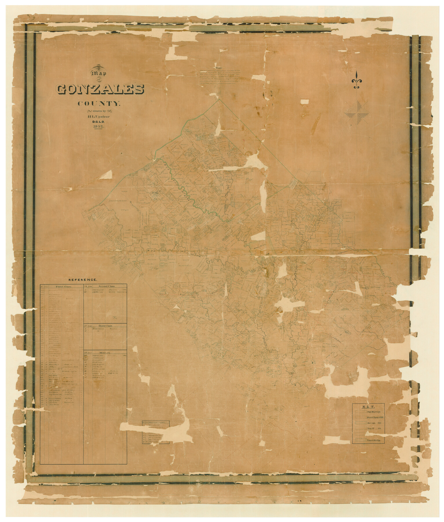
Map of Gonzales County
-
Map/Doc
16839
-
Collection
General Map Collection
-
Object Dates
1842 (Creation Date)
-
People and Organizations
H.L. Upshur (Draftsman)
-
Counties
Gonzales
-
Subjects
County
-
Height x Width
59.5 x 50.0 inches
151.1 x 127.0 cm
-
Comments
Partially adopted by and Jim and Shirley Rhoades in honor of Stanley Froehner and by TSG Architects Inc. and R. L. Reagan.
Conservation funded in 2006.
Part of: General Map Collection
Andrews County Working Sketch 11

Print $20.00
- Digital $50.00
Andrews County Working Sketch 11
1955
Size 20.6 x 25.2 inches
Map/Doc 67057
Runnels County Sketch File 24

Print $20.00
Runnels County Sketch File 24
1930
Size 25.2 x 21.3 inches
Map/Doc 12258
Nueces County Rolled Sketch 5

Print $20.00
- Digital $50.00
Nueces County Rolled Sketch 5
1910
Size 38.1 x 36.8 inches
Map/Doc 9584
Hartley County Working Sketch 3

Print $20.00
- Digital $50.00
Hartley County Working Sketch 3
1928
Size 24.6 x 24.0 inches
Map/Doc 66053
Bexar County Working Sketch 13

Print $20.00
- Digital $50.00
Bexar County Working Sketch 13
1968
Size 43.5 x 43.7 inches
Map/Doc 67329
Frio County Rolled Sketch 8

Print $20.00
- Digital $50.00
Frio County Rolled Sketch 8
1940
Size 19.1 x 36.0 inches
Map/Doc 8901
Kendall County Rolled Sketch 9

Print $20.00
- Digital $50.00
Kendall County Rolled Sketch 9
1990
Size 32.8 x 24.3 inches
Map/Doc 95298

Montague County

Print $20.00
- Digital $50.00
Montague County
1924
Size 46.9 x 33.7 inches
Map/Doc 73243
Trinity County Rolled Sketch 3

Print $40.00
- Digital $50.00
Trinity County Rolled Sketch 3
1948
Size 33.8 x 50.3 inches
Map/Doc 10025
Starr County Working Sketch 29

Print $20.00
- Digital $50.00
Starr County Working Sketch 29
2007
Size 28.6 x 34.0 inches
Map/Doc 87208
Tyler County Rolled Sketch 10

Print $40.00
- Digital $50.00
Tyler County Rolled Sketch 10
1982
Size 48.7 x 35.4 inches
Map/Doc 10032
You may also like
Webb County Working Sketch 83

Print $20.00
- Digital $50.00
Webb County Working Sketch 83
1980
Size 20.7 x 34.9 inches
Map/Doc 72450
Flight Mission No. DAG-26K, Frame 58, Matagorda County

Print $20.00
- Digital $50.00
Flight Mission No. DAG-26K, Frame 58, Matagorda County
1953
Size 18.5 x 16.1 inches
Map/Doc 86578
National Parks, Monuments and Shrines of the United States and Canada

National Parks, Monuments and Shrines of the United States and Canada
1958
Size 25.7 x 19.7 inches
Map/Doc 92377
Tarrant County Working Sketch 7

Print $40.00
- Digital $50.00
Tarrant County Working Sketch 7
1981
Size 18.9 x 54.3 inches
Map/Doc 62424
Roberts County Boundary File 2a

Print $10.00
- Digital $50.00
Roberts County Boundary File 2a
Size 9.5 x 6.4 inches
Map/Doc 58339
Atascosa County Working Sketch 32

Print $20.00
- Digital $50.00
Atascosa County Working Sketch 32
1981
Size 12.9 x 11.8 inches
Map/Doc 67228
Cooke County Sketch File 3

Print $2.00
- Digital $50.00
Cooke County Sketch File 3
1873
Size 6.3 x 7.7 inches
Map/Doc 19222
Nacogdoches County

Print $20.00
- Digital $50.00
Nacogdoches County
1950
Size 47.0 x 43.1 inches
Map/Doc 73248
[Capitol and School Lands in Lamb County]
![91068, [Capitol and School Lands in Lamb County], Twichell Survey Records](https://historictexasmaps.com/wmedia_w700/maps/91068-1.tif.jpg)
Print $20.00
- Digital $50.00
[Capitol and School Lands in Lamb County]
Size 19.2 x 20.5 inches
Map/Doc 91068
Jefferson County Working Sketch Graphic Index

Print $20.00
- Digital $50.00
Jefferson County Working Sketch Graphic Index
1978
Size 47.1 x 41.4 inches
Map/Doc 76595
Flight Mission No. CRC-6R, Frame 38, Chambers County

Print $20.00
- Digital $50.00
Flight Mission No. CRC-6R, Frame 38, Chambers County
1956
Size 18.7 x 22.4 inches
Map/Doc 84971
South Part Brewster Co.

Print $40.00
- Digital $50.00
South Part Brewster Co.
Size 35.2 x 49.8 inches
Map/Doc 66724