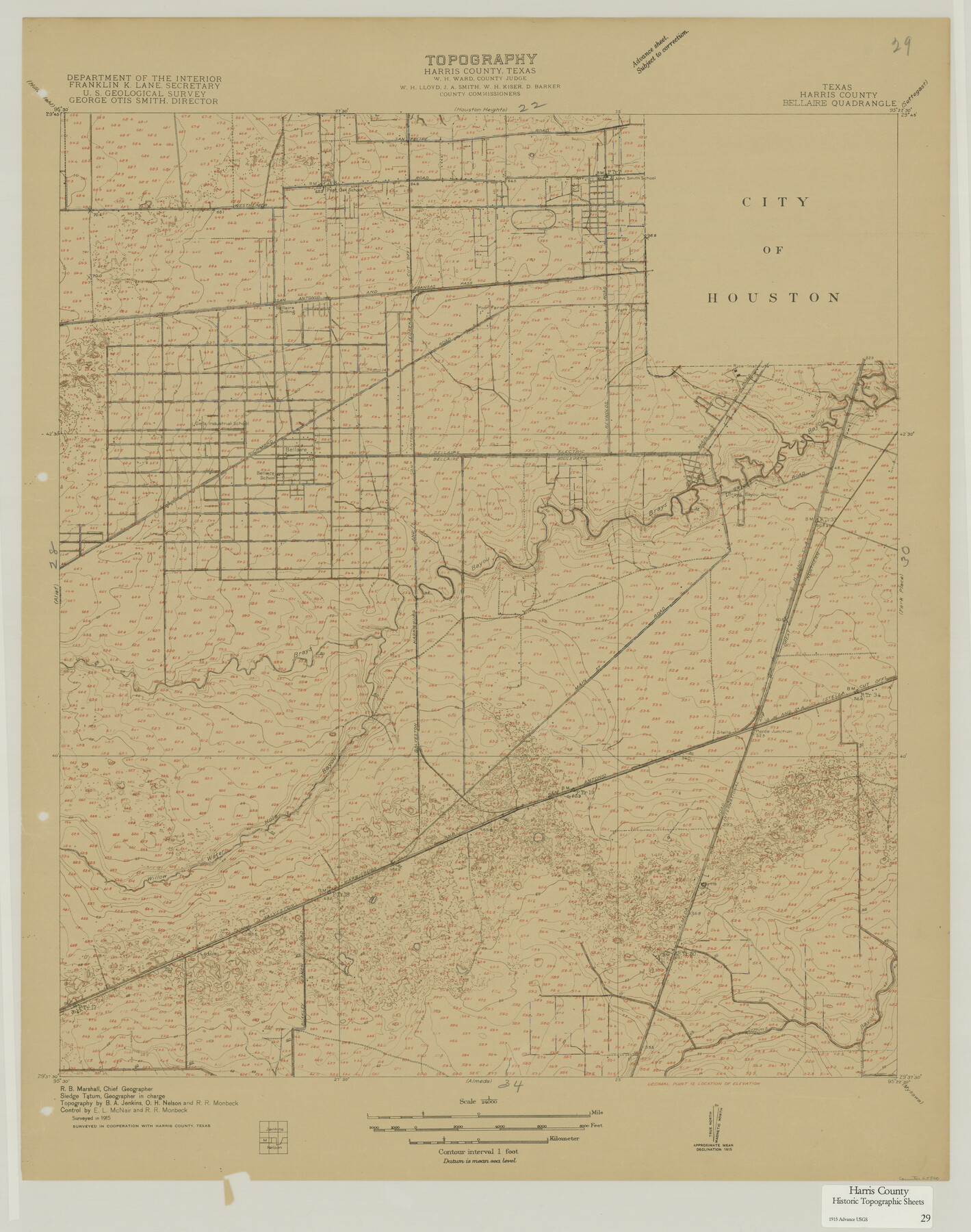
Harris County Historic Topographic 29
Bellaire Quadrangle
-
Map/Doc
65840
-
Collection
General Map Collection
-
Object Dates
1915 (Creation Date)
-
People and Organizations
U. S. Geological Survey (Publisher)
-
Counties
Harris
-
Subjects
Topographic
-
Height x Width
29.1 x 23.0 inches
73.9 x 58.4 cm
Part of: General Map Collection
Flight Mission No. BRA-8M, Frame 119, Jefferson County

Print $20.00
- Digital $50.00
Flight Mission No. BRA-8M, Frame 119, Jefferson County
1953
Size 18.4 x 22.2 inches
Map/Doc 85615
Jones County Sketch File 5

Print $4.00
- Digital $50.00
Jones County Sketch File 5
1859
Size 10.0 x 8.1 inches
Map/Doc 28492
Hardin County Sketch File 65

Print $15.00
- Digital $50.00
Hardin County Sketch File 65
Size 14.4 x 9.0 inches
Map/Doc 25245
Ellis County Sketch File 8

Print $40.00
- Digital $50.00
Ellis County Sketch File 8
1860
Size 12.8 x 16.2 inches
Map/Doc 21841
Jones County Rolled Sketch 3

Print $20.00
- Digital $50.00
Jones County Rolled Sketch 3
2016
Size 22.1 x 34.4 inches
Map/Doc 97130
Trinity County Sketch File 42

Print $60.00
- Digital $50.00
Trinity County Sketch File 42
1858
Size 28.0 x 37.6 inches
Map/Doc 10409
Flight Mission No. DAH-9M, Frame 161, Orange County

Print $20.00
- Digital $50.00
Flight Mission No. DAH-9M, Frame 161, Orange County
1953
Size 18.6 x 22.4 inches
Map/Doc 86860
Flight Mission No. DQO-8K, Frame 132, Galveston County

Print $20.00
- Digital $50.00
Flight Mission No. DQO-8K, Frame 132, Galveston County
1952
Size 18.8 x 22.6 inches
Map/Doc 85197
Flight Mission No. DIX-3P, Frame 137, Aransas County

Print $20.00
- Digital $50.00
Flight Mission No. DIX-3P, Frame 137, Aransas County
1956
Size 17.8 x 18.4 inches
Map/Doc 83767
Colonization and Trade in the New World

Colonization and Trade in the New World
1977
Size 23.1 x 30.3 inches
Map/Doc 96835
Harrison County Sketch File 15

Print $20.00
- Digital $50.00
Harrison County Sketch File 15
Size 23.2 x 23.0 inches
Map/Doc 11690
Hudspeth County Working Sketch 45

Print $20.00
- Digital $50.00
Hudspeth County Working Sketch 45
1983
Size 34.7 x 43.2 inches
Map/Doc 66330
You may also like
Montague County Working Sketch 35

Print $20.00
- Digital $50.00
Montague County Working Sketch 35
1980
Size 24.8 x 31.9 inches
Map/Doc 71101
United States - Gulf Coast - Aransas Pass and Corpus Christi Bay with the coast to latitude 27° 12' Texas

Print $20.00
- Digital $50.00
United States - Gulf Coast - Aransas Pass and Corpus Christi Bay with the coast to latitude 27° 12' Texas
1913
Size 27.5 x 18.3 inches
Map/Doc 72794
Llano County Rolled Sketch 2

Print $20.00
- Digital $50.00
Llano County Rolled Sketch 2
Size 18.2 x 27.3 inches
Map/Doc 9459
Wheeler County Working Sketch 8

Print $40.00
- Digital $50.00
Wheeler County Working Sketch 8
1972
Size 59.4 x 42.0 inches
Map/Doc 72497
Flight Mission No. DAG-17K, Frame 77, Matagorda County

Print $20.00
- Digital $50.00
Flight Mission No. DAG-17K, Frame 77, Matagorda County
1952
Size 16.7 x 16.3 inches
Map/Doc 86336
Treaty to Resolve Pending Boundary Differences and Maintain the Rio Grande and Colorado River as the International Boundary Between the United States of American and Mexico

Print $20.00
- Digital $50.00
Treaty to Resolve Pending Boundary Differences and Maintain the Rio Grande and Colorado River as the International Boundary Between the United States of American and Mexico
1970
Size 10.9 x 35.6 inches
Map/Doc 83104
Atascosa County Rolled Sketch 8

Print $20.00
- Digital $50.00
Atascosa County Rolled Sketch 8
1942
Size 34.8 x 41.9 inches
Map/Doc 8427
Sutton County Working Sketch 64

Print $20.00
- Digital $50.00
Sutton County Working Sketch 64
1963
Size 32.6 x 26.2 inches
Map/Doc 62407
Erath County Sketch File 26

Print $6.00
- Digital $50.00
Erath County Sketch File 26
1896
Size 9.5 x 8.1 inches
Map/Doc 22306
Travis County Sketch File 58

Print $14.00
- Digital $50.00
Travis County Sketch File 58
1948
Size 11.4 x 8.9 inches
Map/Doc 38406
Map of Atascosa County, Texas

Print $20.00
- Digital $50.00
Map of Atascosa County, Texas
1879
Size 23.7 x 29.0 inches
Map/Doc 688
Knox County Sketch File 26

Print $40.00
- Digital $50.00
Knox County Sketch File 26
1957
Size 17.3 x 14.4 inches
Map/Doc 29262