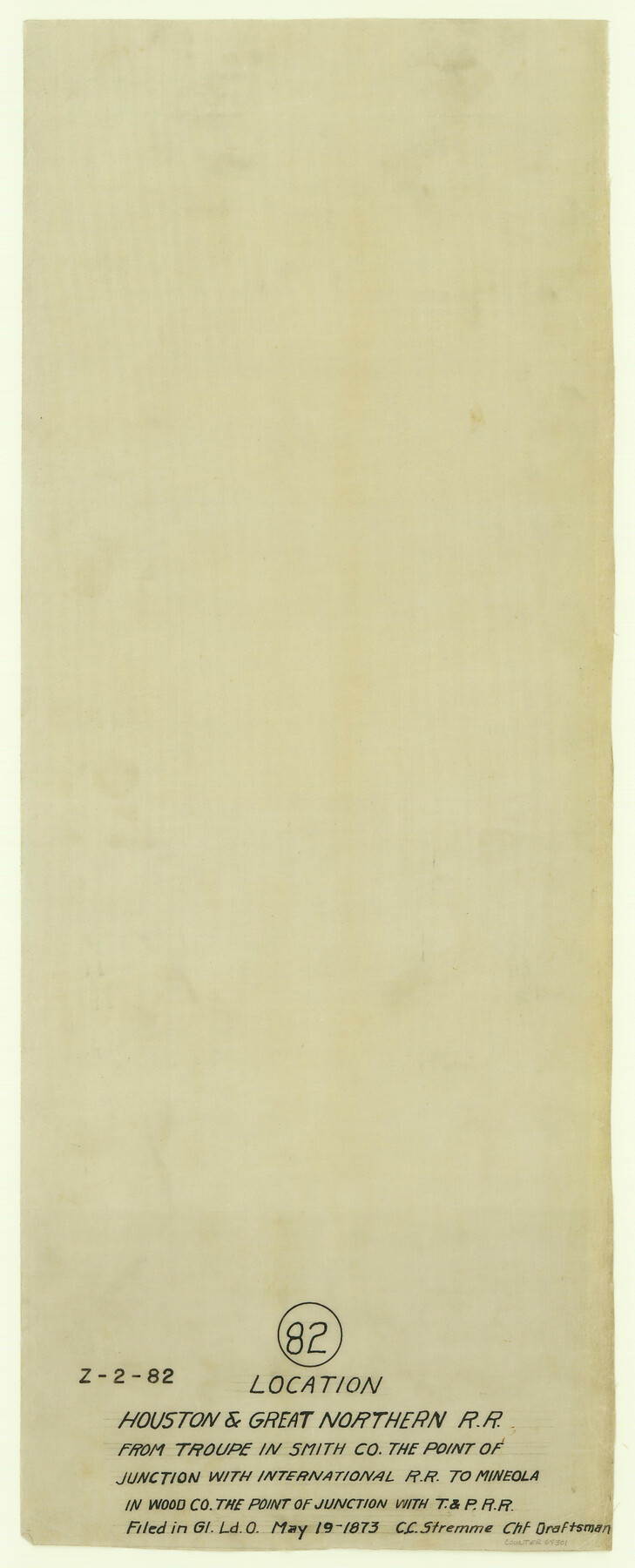
Houston & Great Northern R.R. from Troupe in Smith Co. the point of junction with International R.R. to Mineola in Wood Co. the point of junction with T. & P. R.R.
Z-2-82
-
Map/Doc
64301
-
Collection
General Map Collection
-
Object Dates
1873/5/15 (Creation Date)
1873/5/19 (File Date)
-
People and Organizations
C.C. Stremme (GLO Clerk)
-
Counties
Smith Wood
-
Subjects
Railroads
-
Height x Width
21.2 x 8.6 inches
53.8 x 21.8 cm
-
Medium
paper, manuscript
-
Features
H&GN
IRRC
T&P
Part of: General Map Collection
Parker County Sketch File D

Print $4.00
- Digital $50.00
Parker County Sketch File D
Size 9.9 x 8.2 inches
Map/Doc 33514
Gaines County Rolled Sketch 10

Print $20.00
- Digital $50.00
Gaines County Rolled Sketch 10
1905
Size 16.4 x 35.8 inches
Map/Doc 5930
Fannin County Working Sketch 7

Print $20.00
- Digital $50.00
Fannin County Working Sketch 7
1952
Size 25.4 x 28.5 inches
Map/Doc 69161
Flight Mission No. DAH-17M, Frame 19, Orange County

Print $20.00
- Digital $50.00
Flight Mission No. DAH-17M, Frame 19, Orange County
1953
Size 18.6 x 22.6 inches
Map/Doc 86882
Kinney County Sketch File 35

Print $6.00
- Digital $50.00
Kinney County Sketch File 35
1944
Size 14.2 x 8.7 inches
Map/Doc 29185
Grimes County Sketch File 3

Print $20.00
- Digital $50.00
Grimes County Sketch File 3
1871
Size 10.6 x 12.1 inches
Map/Doc 24626
Reeves County Rolled Sketch 35

Print $20.00
- Digital $50.00
Reeves County Rolled Sketch 35
2013
Size 25.3 x 36.8 inches
Map/Doc 93706
North Sulphur River, Bartley Gin Sheet

Print $20.00
- Digital $50.00
North Sulphur River, Bartley Gin Sheet
1928
Size 21.1 x 42.5 inches
Map/Doc 65173
Presidio County Working Sketch 3

Print $20.00
- Digital $50.00
Presidio County Working Sketch 3
1914
Size 21.5 x 15.9 inches
Map/Doc 71677
Duval County Sketch File 4d

Print $4.00
- Digital $50.00
Duval County Sketch File 4d
1874
Size 10.8 x 8.7 inches
Map/Doc 21288
Deaf Smith County Rolled Sketch 1

Print $20.00
- Digital $50.00
Deaf Smith County Rolled Sketch 1
1965
Size 24.8 x 25.9 inches
Map/Doc 5698
Atascosa County Sketch File 27a

Print $4.00
- Digital $50.00
Atascosa County Sketch File 27a
Size 8.4 x 14.3 inches
Map/Doc 13799
You may also like
Culberson County Sketch File 14

Print $28.00
- Digital $50.00
Culberson County Sketch File 14
1928
Size 13.3 x 8.0 inches
Map/Doc 20176
Frio County Rolled Sketch 15

Print $20.00
- Digital $50.00
Frio County Rolled Sketch 15
1949
Size 26.1 x 39.0 inches
Map/Doc 5922
Starr County Rolled Sketch 10

Print $20.00
- Digital $50.00
Starr County Rolled Sketch 10
1912
Size 15.2 x 24.0 inches
Map/Doc 7797
[T. C. & S. F. Block K11, Capitol Leagues 367, 373, 374, and Blocks D and B]
![90542, [T. C. & S. F. Block K11, Capitol Leagues 367, 373, 374, and Blocks D and B], Twichell Survey Records](https://historictexasmaps.com/wmedia_w700/maps/90542-1.tif.jpg)
Print $3.00
- Digital $50.00
[T. C. & S. F. Block K11, Capitol Leagues 367, 373, 374, and Blocks D and B]
Size 9.8 x 13.5 inches
Map/Doc 90542
Oldham County Sketch File 17

Print $10.00
- Digital $50.00
Oldham County Sketch File 17
1904
Size 7.7 x 6.4 inches
Map/Doc 33267
Flight Mission No. CGI-1N, Frame 166, Cameron County

Print $20.00
- Digital $50.00
Flight Mission No. CGI-1N, Frame 166, Cameron County
1955
Size 18.5 x 22.2 inches
Map/Doc 84501
Located Line of the Panhandle & Gulf Ry. Through State Lands, Public School and University, in Crockett County, Texas

Print $20.00
- Digital $50.00
Located Line of the Panhandle & Gulf Ry. Through State Lands, Public School and University, in Crockett County, Texas
1904
Size 12.2 x 27.3 inches
Map/Doc 64287
Part of Matagorda Bay & Peninsula, Texas

Print $40.00
- Digital $50.00
Part of Matagorda Bay & Peninsula, Texas
1856
Size 31.8 x 51.4 inches
Map/Doc 69978
Hockley County

Print $20.00
- Digital $50.00
Hockley County
1954
Size 41.0 x 36.4 inches
Map/Doc 77313
Flight Mission No. DQN-7K, Frame 34, Calhoun County

Print $20.00
- Digital $50.00
Flight Mission No. DQN-7K, Frame 34, Calhoun County
1953
Size 18.5 x 22.1 inches
Map/Doc 84472
Hood County Sketch File 23a

Print $20.00
- Digital $50.00
Hood County Sketch File 23a
1887
Size 17.2 x 16.5 inches
Map/Doc 11781
Aransas County Rolled Sketch 7A

Print $20.00
- Digital $50.00
Aransas County Rolled Sketch 7A
1954
Size 30.5 x 37.6 inches
Map/Doc 76009