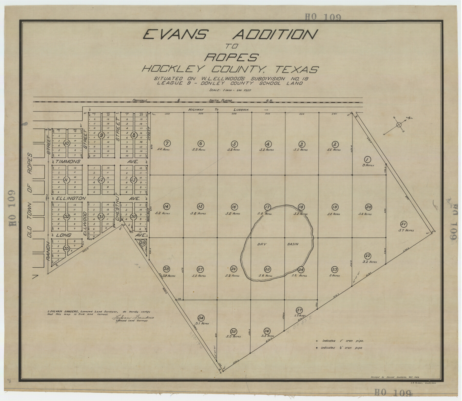
Evans Addition to Ropes Hockley County, Texas Situated on W. L. Ellwood's Subdivision Number 19 League 9, Donley County School Land
HO109
-
Map/Doc
92259
-
Collection
Twichell Survey Records
-
Object Dates
10/1923 (Creation Date)
-
People and Organizations
Sylvan Sanders (Surveyor/Engineer)
C.A. Tubbs (Draftsman)
-
Counties
Hockley
-
Height x Width
24.2 x 21.0 inches
61.5 x 53.3 cm
Part of: Twichell Survey Records
Raymond Marshall Farm

Print $3.00
- Digital $50.00
Raymond Marshall Farm
Size 9.8 x 12.6 inches
Map/Doc 92310
[Western part of Crockett County]
![90323, [Western part of Crockett County], Twichell Survey Records](https://historictexasmaps.com/wmedia_w700/maps/90323-1.tif.jpg)
Print $20.00
- Digital $50.00
[Western part of Crockett County]
Size 17.3 x 14.3 inches
Map/Doc 90323
[River Secs. 68-73, Archer County School Land League 3 and surrounding surveys]
![90468, [River Secs. 68-73, Archer County School Land League 3 and surrounding surveys], Twichell Survey Records](https://historictexasmaps.com/wmedia_w700/maps/90468-1.tif.jpg)
Print $20.00
- Digital $50.00
[River Secs. 68-73, Archer County School Land League 3 and surrounding surveys]
Size 38.4 x 36.4 inches
Map/Doc 90468
[Southeast Portion of Motley County]
![91508, [Southeast Portion of Motley County], Twichell Survey Records](https://historictexasmaps.com/wmedia_w700/maps/91508-1.tif.jpg)
Print $20.00
- Digital $50.00
[Southeast Portion of Motley County]
Size 31.2 x 34.3 inches
Map/Doc 91508
Cienega Ranch

Print $20.00
- Digital $50.00
Cienega Ranch
1947
Size 27.6 x 28.3 inches
Map/Doc 92323
[Sketch of surveys in the vicinity of sections 171 and 172 along Pedernales]
![91882, [Sketch of surveys in the vicinity of sections 171 and 172 along Pedernales], Twichell Survey Records](https://historictexasmaps.com/wmedia_w700/maps/91882-1.tif.jpg)
Print $20.00
- Digital $50.00
[Sketch of surveys in the vicinity of sections 171 and 172 along Pedernales]
Size 17.2 x 12.9 inches
Map/Doc 91882
![93063, [Block B11], Twichell Survey Records](https://historictexasmaps.com/wmedia_w700/maps/93063-1.tif.jpg)
[I. & G. N, Sections 8-13]
![91047, [I. & G. N, Sections 8-13], Twichell Survey Records](https://historictexasmaps.com/wmedia_w700/maps/91047-1.tif.jpg)
Print $20.00
- Digital $50.00
[I. & G. N, Sections 8-13]
Size 25.2 x 12.1 inches
Map/Doc 91047
Correct Map Lamb County (skeleton sketch)

Print $40.00
- Digital $50.00
Correct Map Lamb County (skeleton sketch)
Size 56.3 x 79.2 inches
Map/Doc 93140
[R. M. Thompson Block T2 and John H. Stephens Block S2 Conflict]
![91056, [R. M. Thompson Block T2 and John H. Stephens Block S2 Conflict], Twichell Survey Records](https://historictexasmaps.com/wmedia_w700/maps/91056-1.tif.jpg)
Print $20.00
- Digital $50.00
[R. M. Thompson Block T2 and John H. Stephens Block S2 Conflict]
Size 20.9 x 30.6 inches
Map/Doc 91056
[Area Surrounding Lee County School Land]
![90887, [Area Surrounding Lee County School Land], Twichell Survey Records](https://historictexasmaps.com/wmedia_w700/maps/90887-1.tif.jpg)
Print $20.00
- Digital $50.00
[Area Surrounding Lee County School Land]
1907
Size 13.9 x 19.2 inches
Map/Doc 90887
[Block XO3, Parts of Blocks Y2 and 1, and vicinity]
![91182, [Block XO3, Parts of Blocks Y2 and 1, and vicinity], Twichell Survey Records](https://historictexasmaps.com/wmedia_w700/maps/91182-1.tif.jpg)
Print $20.00
- Digital $50.00
[Block XO3, Parts of Blocks Y2 and 1, and vicinity]
Size 13.1 x 13.9 inches
Map/Doc 91182
You may also like
Webb County Working Sketch 5

Print $20.00
- Digital $50.00
Webb County Working Sketch 5
1909
Size 20.1 x 15.4 inches
Map/Doc 72370
Sketch showing progress of topographical work Laguna Madre and vicinity from Rainey Is. to Baffins Bay, Coast of Texas Sect. IX [and accompanying letter]
![72958, Sketch showing progress of topographical work Laguna Madre and vicinity from Rainey Is. to Baffins Bay, Coast of Texas Sect. IX [and accompanying letter], General Map Collection](https://historictexasmaps.com/wmedia_w700/maps/72958.tif.jpg)
Print $2.00
- Digital $50.00
Sketch showing progress of topographical work Laguna Madre and vicinity from Rainey Is. to Baffins Bay, Coast of Texas Sect. IX [and accompanying letter]
1881
Size 11.2 x 8.8 inches
Map/Doc 72958
Starr County Sketch File 36

Print $26.00
- Digital $50.00
Starr County Sketch File 36
1939
Size 14.3 x 8.7 inches
Map/Doc 36977
Lipscomb County Rolled Sketch 3

Print $20.00
- Digital $50.00
Lipscomb County Rolled Sketch 3
1886
Size 24.2 x 31.0 inches
Map/Doc 6629
Flight Mission No. DAG-16K, Frame 71, Matagorda County

Print $20.00
- Digital $50.00
Flight Mission No. DAG-16K, Frame 71, Matagorda County
1952
Size 16.4 x 16.4 inches
Map/Doc 86317
Collin County Working Sketch 3

Print $20.00
- Digital $50.00
Collin County Working Sketch 3
1935
Size 25.8 x 41.7 inches
Map/Doc 68097
[A. B. & M. Block 2]
![91794, [A. B. & M. Block 2], Twichell Survey Records](https://historictexasmaps.com/wmedia_w700/maps/91794-1.tif.jpg)
Print $2.00
- Digital $50.00
[A. B. & M. Block 2]
Size 7.1 x 14.1 inches
Map/Doc 91794
[Meanders of a navigable river, perhaps Cow Bayou]
![66, [Meanders of a navigable river, perhaps Cow Bayou], General Map Collection](https://historictexasmaps.com/wmedia_w700/maps/66.tif.jpg)
Print $20.00
- Digital $50.00
[Meanders of a navigable river, perhaps Cow Bayou]
1842
Size 14.0 x 16.6 inches
Map/Doc 66
Refugio County Working Sketch 1

Print $20.00
- Digital $50.00
Refugio County Working Sketch 1
1917
Size 18.8 x 18.0 inches
Map/Doc 63510
Working Sketch Carson County

Print $3.00
- Digital $50.00
Working Sketch Carson County
1907
Size 10.6 x 17.1 inches
Map/Doc 90223
Plat of Corpus Christi

Print $20.00
Plat of Corpus Christi
1850
Size 18.0 x 27.2 inches
Map/Doc 76269
Johnson County, Texas

Print $20.00
- Digital $50.00
Johnson County, Texas
1871
Size 18.2 x 23.3 inches
Map/Doc 734