Smith County Rolled Sketch 2
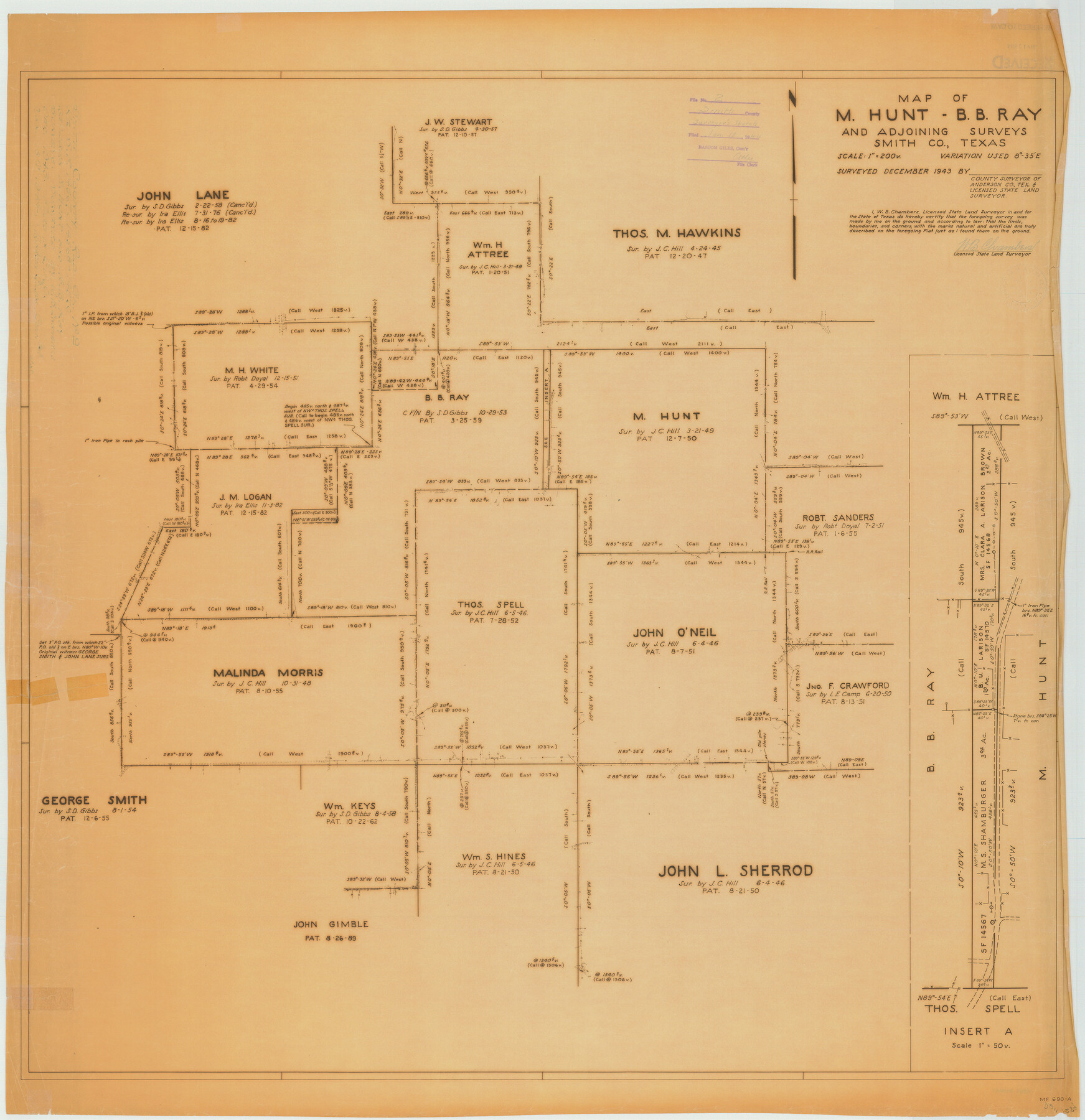
Map of M. Hunt - B.B. Ray and adjoining surveys, Smith Co., Texas
-
Map/Doc
75931
-
Collection
General Map Collection
-
Object Dates
1943 (Survey Date)
1944/1/18 (File Date)
-
People and Organizations
W.B. Chambers (Surveyor/Engineer)
-
Counties
Smith
-
Subjects
Surveying Rolled Sketch
-
Height x Width
36.6 x 35.5 inches
93.0 x 90.2 cm
-
Medium
van dyke/brownline/sepia
-
Scale
1" = 200 varas
Part of: General Map Collection
Titus County Sketch File 10

Print $4.00
- Digital $50.00
Titus County Sketch File 10
1871
Size 8.1 x 12.9 inches
Map/Doc 38148
Hunt County Rolled Sketch 5

Print $20.00
- Digital $50.00
Hunt County Rolled Sketch 5
1966
Size 23.9 x 23.7 inches
Map/Doc 6274
Crockett County Working Sketch Graphic Index - northeast part

Print $20.00
- Digital $50.00
Crockett County Working Sketch Graphic Index - northeast part
1976
Size 35.6 x 46.4 inches
Map/Doc 76511
Karte des Staates Texas (aufgenommen in die Union 1846) nach der neuesten Eintheilung

Print $20.00
- Digital $50.00
Karte des Staates Texas (aufgenommen in die Union 1846) nach der neuesten Eintheilung
1849
Size 13.6 x 16.6 inches
Map/Doc 90066
Brewster County Rolled Sketch 130

Print $20.00
- Digital $50.00
Brewster County Rolled Sketch 130
1978
Size 18.4 x 24.6 inches
Map/Doc 5302
Briscoe County Sketch File 2

Print $40.00
- Digital $50.00
Briscoe County Sketch File 2
1880
Size 18.3 x 15.4 inches
Map/Doc 10991
Runnels County Working Sketch 12

Print $20.00
- Digital $50.00
Runnels County Working Sketch 12
1950
Size 27.7 x 33.0 inches
Map/Doc 63608
Val Verde County Rolled Sketch 72

Print $20.00
- Digital $50.00
Val Verde County Rolled Sketch 72
Size 15.2 x 28.5 inches
Map/Doc 8134
Polk County Rolled Sketch 29

Print $86.00
- Digital $50.00
Polk County Rolled Sketch 29
1954
Size 9.3 x 14.9 inches
Map/Doc 48066
PSL Field Notes for Blocks G, L, P, and Q in Cochran and Yoakum Counties and Blocks U, V, W, Y, and Z in Cochran County

PSL Field Notes for Blocks G, L, P, and Q in Cochran and Yoakum Counties and Blocks U, V, W, Y, and Z in Cochran County
Map/Doc 81645
Washington County Sketch File 7

Print $4.00
- Digital $50.00
Washington County Sketch File 7
1873
Size 12.2 x 7.6 inches
Map/Doc 39654
Uvalde County Working Sketch 59

Print $20.00
- Digital $50.00
Uvalde County Working Sketch 59
1989
Size 25.1 x 39.1 inches
Map/Doc 72129
You may also like
Tom Green County Working Sketch 3

Print $20.00
- Digital $50.00
Tom Green County Working Sketch 3
1933
Size 47.5 x 40.2 inches
Map/Doc 69372
Bandera County Sketch File 23

Print $40.00
- Digital $50.00
Bandera County Sketch File 23
1881
Size 16.1 x 13.7 inches
Map/Doc 10895
Reeves County Working Sketch 22

Print $20.00
- Digital $50.00
Reeves County Working Sketch 22
1966
Size 31.2 x 46.8 inches
Map/Doc 63465
Crockett County Working Sketch 67

Print $20.00
- Digital $50.00
Crockett County Working Sketch 67
1959
Size 26.5 x 31.5 inches
Map/Doc 68400
Stephens County Rolled Sketch 4

Print $20.00
- Digital $50.00
Stephens County Rolled Sketch 4
Size 20.0 x 18.5 inches
Map/Doc 7841
Webb County Sketch File 69

Print $6.00
- Digital $50.00
Webb County Sketch File 69
1975
Size 15.1 x 9.9 inches
Map/Doc 39873
Map showing the fortification at Point Isabel

Print $20.00
- Digital $50.00
Map showing the fortification at Point Isabel
1864
Size 18.3 x 27.9 inches
Map/Doc 72921
Wise County Sketch File F

Print $20.00
- Digital $50.00
Wise County Sketch File F
1857
Size 16.2 x 29.2 inches
Map/Doc 12704
Upton County Rolled Sketch 13

Print $20.00
- Digital $50.00
Upton County Rolled Sketch 13
1926
Size 32.5 x 43.6 inches
Map/Doc 10037
Pecos County Rolled Sketch 124

Print $20.00
- Digital $50.00
Pecos County Rolled Sketch 124
Size 22.8 x 18.8 inches
Map/Doc 7265
[Map of Chicago, Rock Island & Texas Railway through Tarrant County, Texas]
![64412, [Map of Chicago, Rock Island & Texas Railway through Tarrant County, Texas], General Map Collection](https://historictexasmaps.com/wmedia_w700/maps/64412.tif.jpg)
Print $40.00
- Digital $50.00
[Map of Chicago, Rock Island & Texas Railway through Tarrant County, Texas]
1893
Size 22.9 x 122.0 inches
Map/Doc 64412
Reeves County Working Sketch 13

Print $20.00
- Digital $50.00
Reeves County Working Sketch 13
1959
Size 30.5 x 33.4 inches
Map/Doc 63456