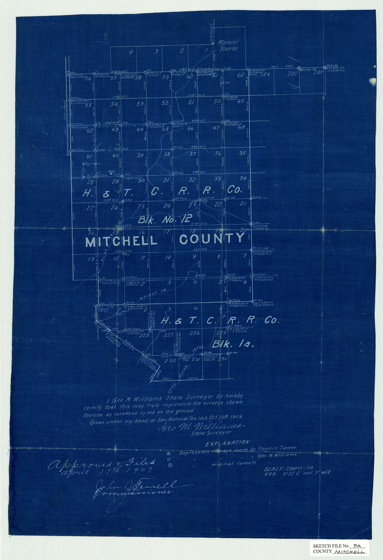
Mitchell County Sketch File 7A
[H&TCRRCo. Block 12, Mitchell County, Texas]
-
Map/Doc
12097
-
Collection
General Map Collection
-
Object Dates
10/19/1906 (Creation Date)
4/17/1907 (File Date)
-
People and Organizations
George M. Williams (Surveyor/Engineer)
John J. Terrell (GLO Commissioner)
-
Counties
Mitchell Nolan
-
Subjects
Surveying Sketch File
-
Height x Width
20.4 x 14.0 inches
51.8 x 35.6 cm
-
Medium
blueprint/diazo
-
Scale
1:2000
-
Features
Silver Creek
Walnut Creek
Little Silver Creek
Part of: General Map Collection
Flight Mission No. BQR-4K, Frame 64, Brazoria County

Print $20.00
- Digital $50.00
Flight Mission No. BQR-4K, Frame 64, Brazoria County
1952
Size 18.7 x 22.4 inches
Map/Doc 83997
Jefferson County Sketch File 8a

Print $42.00
- Digital $50.00
Jefferson County Sketch File 8a
Size 8.6 x 7.8 inches
Map/Doc 28120
Angelina County Sketch File 12

Print $4.00
- Digital $50.00
Angelina County Sketch File 12
1860
Size 14.1 x 8.1 inches
Map/Doc 12955
Robertson Co.

Print $40.00
- Digital $50.00
Robertson Co.
1945
Size 49.5 x 40.3 inches
Map/Doc 95627
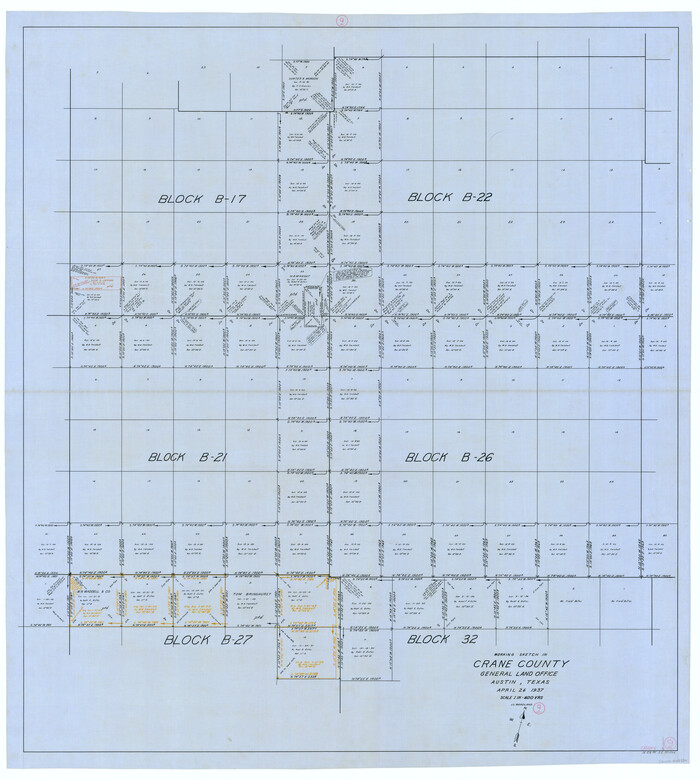
Crane County Working Sketch 9
Print $20.00
- Digital $50.00
Crane County Working Sketch 9
1937
Size 47.6 x 42.8 inches
Map/Doc 68286
Flight Mission No. DQN-2K, Frame 45, Calhoun County

Print $20.00
- Digital $50.00
Flight Mission No. DQN-2K, Frame 45, Calhoun County
1953
Size 18.4 x 22.2 inches
Map/Doc 84250
Flight Mission No. CGI-8AA, Frame 146, Cameron County

Print $20.00
- Digital $50.00
Flight Mission No. CGI-8AA, Frame 146, Cameron County
1962
Size 18.6 x 18.3 inches
Map/Doc 84533
Colorado County Working Sketch 33

Print $20.00
- Digital $50.00
Colorado County Working Sketch 33
1988
Size 38.7 x 32.4 inches
Map/Doc 68133
Bowie County Working Sketch 24

Print $20.00
- Digital $50.00
Bowie County Working Sketch 24
1974
Size 47.1 x 40.1 inches
Map/Doc 67428
San Antonio, Texas Street Map

San Antonio, Texas Street Map
1997
Size 36.5 x 46.7 inches
Map/Doc 96868
Callahan County Sketch File 17

Print $18.00
- Digital $50.00
Callahan County Sketch File 17
Size 11.0 x 8.5 inches
Map/Doc 93444
Edwards County Working Sketch 74

Print $20.00
- Digital $50.00
Edwards County Working Sketch 74
1959
Size 23.6 x 38.4 inches
Map/Doc 68950
You may also like
Menard County Boundary File 3

Print $4.00
- Digital $50.00
Menard County Boundary File 3
Size 10.6 x 8.0 inches
Map/Doc 57072
Crane County Working Sketch 32

Print $20.00
- Digital $50.00
Crane County Working Sketch 32
1984
Size 37.6 x 43.1 inches
Map/Doc 68309
Dimmit County Sketch File 1

Print $42.00
- Digital $50.00
Dimmit County Sketch File 1
1851
Size 8.8 x 7.5 inches
Map/Doc 21050
Edwards County Rolled Sketch 31

Print $20.00
- Digital $50.00
Edwards County Rolled Sketch 31
1982
Size 30.5 x 39.4 inches
Map/Doc 8849
General Highway Map. Detail of Cities and Towns in Grayson County, Texas [Denison and Sherman]
![79486, General Highway Map. Detail of Cities and Towns in Grayson County, Texas [Denison and Sherman], Texas State Library and Archives](https://historictexasmaps.com/wmedia_w700/maps/79486.tif.jpg)
Print $20.00
General Highway Map. Detail of Cities and Towns in Grayson County, Texas [Denison and Sherman]
1961
Size 18.1 x 24.6 inches
Map/Doc 79486
Galveston County NRC Article 33.136 Sketch 81

Print $202.00
- Digital $50.00
Galveston County NRC Article 33.136 Sketch 81
2015
Size 34.0 x 22.0 inches
Map/Doc 94976
Guadalupe County Sketch File 20

Print $6.00
- Digital $50.00
Guadalupe County Sketch File 20
1912
Size 11.1 x 8.7 inches
Map/Doc 24699
Brazos River, Brazos River Sheet 8

Print $4.00
- Digital $50.00
Brazos River, Brazos River Sheet 8
1926
Size 22.6 x 29.2 inches
Map/Doc 65301
Pecos County Working Sketch 98

Print $20.00
- Digital $50.00
Pecos County Working Sketch 98
1970
Size 42.8 x 31.8 inches
Map/Doc 71571
Taylor County Sketch File 20

Print $20.00
- Digital $50.00
Taylor County Sketch File 20
1950
Size 32.1 x 46.1 inches
Map/Doc 10385
Shelby County

Print $20.00
- Digital $50.00
Shelby County
1945
Size 41.6 x 45.9 inches
Map/Doc 73288
Guadalupe County

Print $20.00
- Digital $50.00
Guadalupe County
1880
Size 24.9 x 22.6 inches
Map/Doc 4553