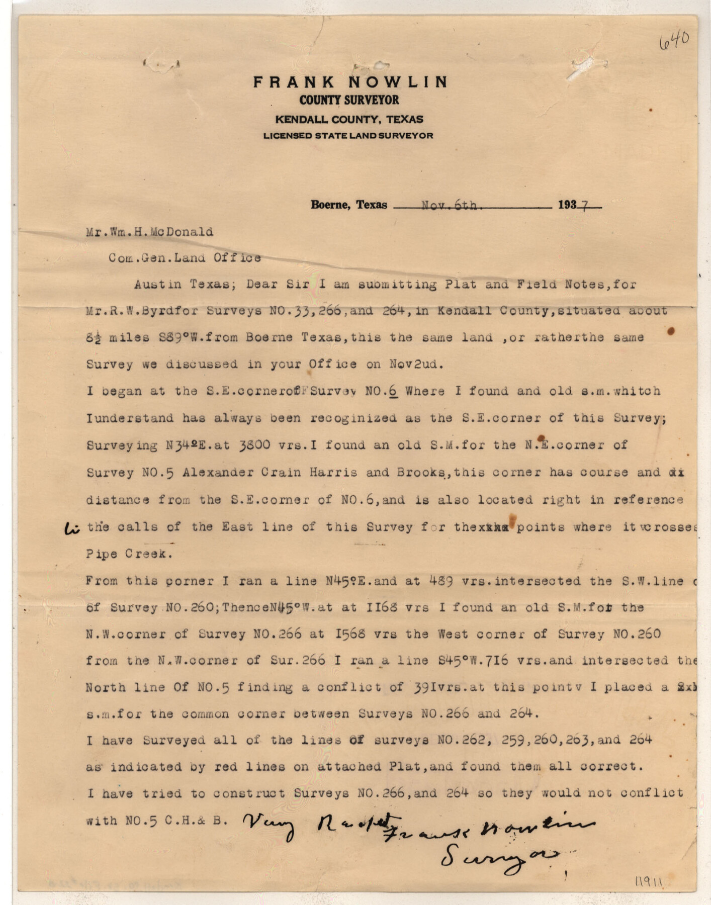
Kendall County Sketch File 22B
Byrd Ranch on Kendall-Bandera County Line
-
Map/Doc
11911
-
Collection
General Map Collection
-
Object Dates
11/30/1937 (Creation Date)
12/30/1937 (File Date)
11/6/1937 (Correspondence Date)
11/30/1937 (Survey Date)
-
People and Organizations
Frank Nowlin (Surveyor/Engineer)
-
Counties
Kendall Bandera
-
Subjects
Surveying Sketch File
-
Height x Width
19.3 x 24.6 inches
49.0 x 62.5 cm
-
Medium
paper, print
-
Features
Pipe Creek
Part of: General Map Collection
Hays County Working Sketch 22

Print $20.00
- Digital $50.00
Hays County Working Sketch 22
2000
Size 47.1 x 36.9 inches
Map/Doc 76051
Ector County Working Sketch 4

Print $20.00
- Digital $50.00
Ector County Working Sketch 4
1940
Size 25.8 x 30.0 inches
Map/Doc 68847
Titus County Working Sketch 3

Print $20.00
- Digital $50.00
Titus County Working Sketch 3
Size 21.7 x 31.8 inches
Map/Doc 69364
[Sketch for Mineral Application 26501 - Sabine River, T. A. Oldhausen]
![2832, [Sketch for Mineral Application 26501 - Sabine River, T. A. Oldhausen], General Map Collection](https://historictexasmaps.com/wmedia_w700/maps/2832.tif.jpg)
Print $20.00
- Digital $50.00
[Sketch for Mineral Application 26501 - Sabine River, T. A. Oldhausen]
1931
Size 24.0 x 36.0 inches
Map/Doc 2832
Terrell County Working Sketch 55

Print $20.00
- Digital $50.00
Terrell County Working Sketch 55
1959
Size 25.9 x 43.4 inches
Map/Doc 62148
Map of Jefferson County

Print $20.00
- Digital $50.00
Map of Jefferson County
1896
Size 25.3 x 21.6 inches
Map/Doc 3731
Flight Mission No. CGI-3N, Frame 166, Cameron County

Print $20.00
- Digital $50.00
Flight Mission No. CGI-3N, Frame 166, Cameron County
1954
Size 18.6 x 22.2 inches
Map/Doc 84630
Outer Continental Shelf Leasing Maps (Texas Offshore Operations)

Print $20.00
- Digital $50.00
Outer Continental Shelf Leasing Maps (Texas Offshore Operations)
1954
Size 14.7 x 14.2 inches
Map/Doc 75834
Hutchinson County Boundary File 4

Print $17.00
- Digital $50.00
Hutchinson County Boundary File 4
Size 14.3 x 8.7 inches
Map/Doc 55305
Fractional Township No. 10 South Range No. 24 East of the Indian Meridian, Indian Territory

Print $20.00
- Digital $50.00
Fractional Township No. 10 South Range No. 24 East of the Indian Meridian, Indian Territory
1898
Size 19.1 x 24.2 inches
Map/Doc 75242
Brazoria County Working Sketch 27

Print $20.00
- Digital $50.00
Brazoria County Working Sketch 27
1970
Size 41.8 x 32.5 inches
Map/Doc 67512
Stephens County Sketch File 22

Print $40.00
- Digital $50.00
Stephens County Sketch File 22
1919
Size 22.1 x 28.8 inches
Map/Doc 12352
You may also like
Motley County Sketch File 18 (N)

Print $4.00
- Digital $50.00
Motley County Sketch File 18 (N)
1913
Size 11.3 x 8.7 inches
Map/Doc 32062
[Area north of Leagues 1 & 4, Morris County School Land]
![90353, [Area north of Leagues 1 & 4, Morris County School Land], Twichell Survey Records](https://historictexasmaps.com/wmedia_w700/maps/90353-1.tif.jpg)
Print $20.00
- Digital $50.00
[Area north of Leagues 1 & 4, Morris County School Land]
Size 21.3 x 16.0 inches
Map/Doc 90353
Aransas County Sketch File 32

Print $12.00
- Digital $50.00
Aransas County Sketch File 32
1919
Size 14.2 x 9.0 inches
Map/Doc 13297

Upper Galveston Bay, Houston Ship Channel, Dollar Pt. to Atkinson I.

Print $40.00
- Digital $50.00
Upper Galveston Bay, Houston Ship Channel, Dollar Pt. to Atkinson I.
1973
Size 49.8 x 36.8 inches
Map/Doc 69896
Map of the Straits of Florida and Gulf of Mexico

Print $20.00
- Digital $50.00
Map of the Straits of Florida and Gulf of Mexico
1851
Size 18.3 x 27.4 inches
Map/Doc 72675
Leon County Sketch File 30

Print $6.00
- Digital $50.00
Leon County Sketch File 30
1951
Size 11.2 x 8.7 inches
Map/Doc 29829
Reeves County

Print $40.00
- Digital $50.00
Reeves County
1945
Size 49.4 x 40.8 inches
Map/Doc 95624
[State Line - 103rd Meridian - in relation to Leagues]
![91551, [State Line - 103rd Meridian - in relation to Leagues], Twichell Survey Records](https://historictexasmaps.com/wmedia_w700/maps/91551-2.tif.jpg)
Print $20.00
- Digital $50.00
[State Line - 103rd Meridian - in relation to Leagues]
Size 19.9 x 8.3 inches
Map/Doc 91551
Baylor County

Print $20.00
- Digital $50.00
Baylor County
1961
Size 43.0 x 35.2 inches
Map/Doc 95426
Map of Donley County

Print $20.00
- Digital $50.00
Map of Donley County
1894
Size 44.6 x 35.8 inches
Map/Doc 16823
Dawson County Working Sketch 14

Print $20.00
- Digital $50.00
Dawson County Working Sketch 14
1952
Size 15.5 x 12.8 inches
Map/Doc 68558