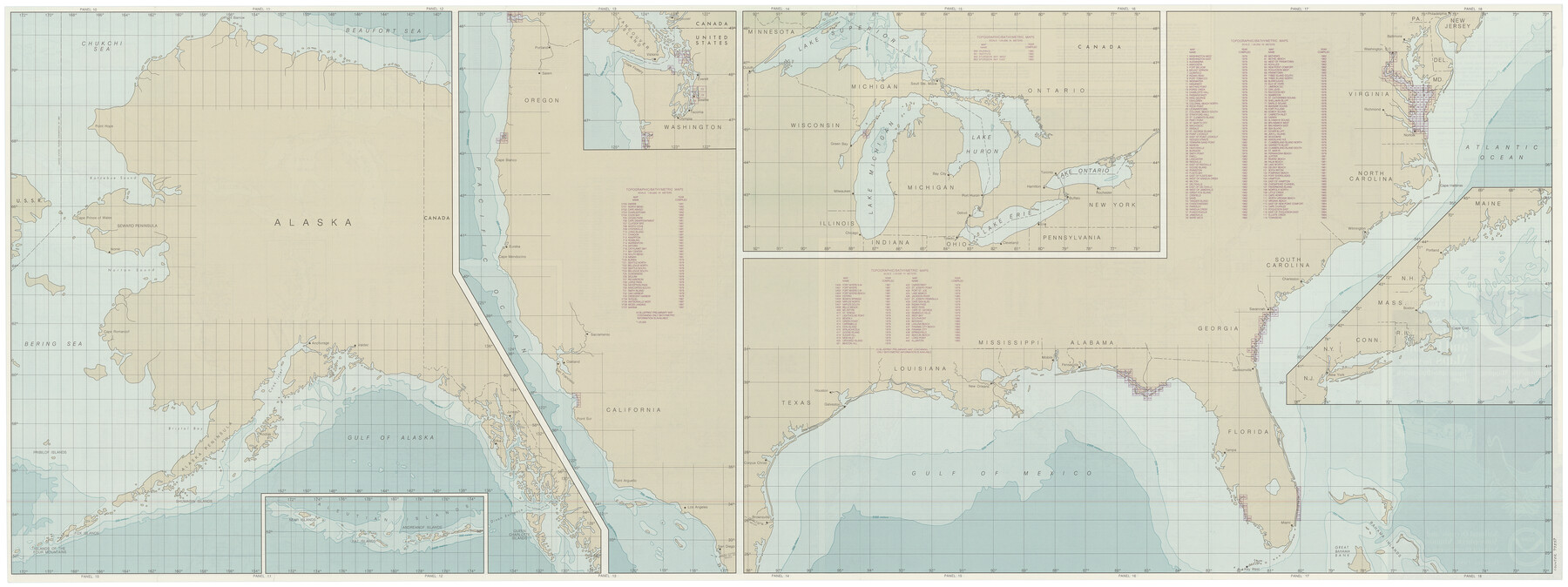
United States Bathymetric and Fishing Maps including Topographic/Bathymetric Maps
-
Map/Doc
73557
-
Collection
General Map Collection
-
Object Dates
10/1989 (Creation Date)
-
Subjects
Nautical Charts
-
Height x Width
20.4 x 54.4 inches
51.8 x 138.2 cm
-
Comments
dual-sided map
Part of: General Map Collection
Map of Crockett County

Print $40.00
- Digital $50.00
Map of Crockett County
1878
Size 60.2 x 97.2 inches
Map/Doc 78701
Amistad International Reservoir on Rio Grande 88

Print $20.00
- Digital $50.00
Amistad International Reservoir on Rio Grande 88
1949
Size 28.5 x 40.2 inches
Map/Doc 75517
Dimmit County Boundary File 10

Print $32.00
- Digital $50.00
Dimmit County Boundary File 10
Size 14.2 x 8.6 inches
Map/Doc 52604
Culberson County Working Sketch 50

Print $20.00
- Digital $50.00
Culberson County Working Sketch 50
1972
Size 32.0 x 35.1 inches
Map/Doc 68504
Comanche County Sketch File 20a

Print $2.00
- Digital $50.00
Comanche County Sketch File 20a
Size 12.9 x 8.2 inches
Map/Doc 19105
Johnson County Rolled Sketch 3

Print $20.00
- Digital $50.00
Johnson County Rolled Sketch 3
1990
Size 28.7 x 28.0 inches
Map/Doc 6448
[Map of the River Sabine from its mouth on the Gulf of Mexico in the sea to Logan's Ferry in Latitude 31° 58' 24" North]
![94006, [Map of the River Sabine from its mouth on the Gulf of Mexico in the sea to Logan's Ferry in Latitude 31° 58' 24" North], General Map Collection](https://historictexasmaps.com/wmedia_w700/maps/94006.tif.jpg)
Print $20.00
- Digital $50.00
[Map of the River Sabine from its mouth on the Gulf of Mexico in the sea to Logan's Ferry in Latitude 31° 58' 24" North]
Size 37.7 x 31.6 inches
Map/Doc 94006
Nolan County Rolled Sketch 2A

Print $20.00
- Digital $50.00
Nolan County Rolled Sketch 2A
Size 26.9 x 34.8 inches
Map/Doc 6861
Harrison County Sketch File 15

Print $20.00
- Digital $50.00
Harrison County Sketch File 15
Size 23.2 x 23.0 inches
Map/Doc 11690
Gregg County Boundary File 6

Print $6.00
- Digital $50.00
Gregg County Boundary File 6
Size 8.5 x 5.8 inches
Map/Doc 54001
Tyler County Sketch File 6-3

Print $20.00
- Digital $50.00
Tyler County Sketch File 6-3
1861
Size 20.0 x 22.1 inches
Map/Doc 12499
Map of Africa (Inset: Liberia and Sierra Leone)

Print $20.00
- Digital $50.00
Map of Africa (Inset: Liberia and Sierra Leone)
1844
Size 9.5 x 12.1 inches
Map/Doc 93549
You may also like
[Blocks D3 and GP]
![91505, [Blocks D3 and GP], Twichell Survey Records](https://historictexasmaps.com/wmedia_w700/maps/91505-1.tif.jpg)
Print $20.00
- Digital $50.00
[Blocks D3 and GP]
Size 18.9 x 20.2 inches
Map/Doc 91505
Map of the Fort Worth and Denver City Railway, through Wilbarger County Texas, 1882

Print $40.00
- Digital $50.00
Map of the Fort Worth and Denver City Railway, through Wilbarger County Texas, 1882
Size 22.6 x 79.4 inches
Map/Doc 64427
[Township 5-S, Blocks 36, 37 & 38]
![92292, [Township 5-S, Blocks 36, 37 & 38], Twichell Survey Records](https://historictexasmaps.com/wmedia_w700/maps/92292-1.tif.jpg)
Print $20.00
- Digital $50.00
[Township 5-S, Blocks 36, 37 & 38]
1952
Size 27.7 x 26.6 inches
Map/Doc 92292
Leon County Working Sketch 26

Print $20.00
- Digital $50.00
Leon County Working Sketch 26
1969
Size 43.1 x 46.9 inches
Map/Doc 70425
Pecos County Working Sketch 109

Print $40.00
- Digital $50.00
Pecos County Working Sketch 109
1972
Size 34.8 x 56.9 inches
Map/Doc 71582
[H. & T. C. Block 47]
![91190, [H. & T. C. Block 47], Twichell Survey Records](https://historictexasmaps.com/wmedia_w700/maps/91190-1.tif.jpg)
Print $20.00
- Digital $50.00
[H. & T. C. Block 47]
1874
Size 21.1 x 12.2 inches
Map/Doc 91190
Webb County Sketch File 73

Print $20.00
- Digital $50.00
Webb County Sketch File 73
2020
Size 11.0 x 8.5 inches
Map/Doc 95917
Real County Sketch File 16

Print $20.00
- Digital $50.00
Real County Sketch File 16
1934
Size 23.1 x 22.1 inches
Map/Doc 12234
Index for Texas Railroad ROW & track maps available on microfilm at THD & Archives and Records

Print $2.00
- Digital $50.00
Index for Texas Railroad ROW & track maps available on microfilm at THD & Archives and Records
1977
Size 11.1 x 8.9 inches
Map/Doc 60755
Live Oak County Working Sketch 8

Print $20.00
- Digital $50.00
Live Oak County Working Sketch 8
1937
Size 11.1 x 13.3 inches
Map/Doc 70593
[Blk. O1, W. H. Godair]
![90632, [Blk. O1, W. H. Godair], Twichell Survey Records](https://historictexasmaps.com/wmedia_w700/maps/90632-1.tif.jpg)
Print $20.00
- Digital $50.00
[Blk. O1, W. H. Godair]
1913
Size 30.1 x 10.3 inches
Map/Doc 90632
Yoakum County Sketch File 17

Print $48.00
- Digital $50.00
Yoakum County Sketch File 17
1898
Size 14.5 x 8.9 inches
Map/Doc 40796