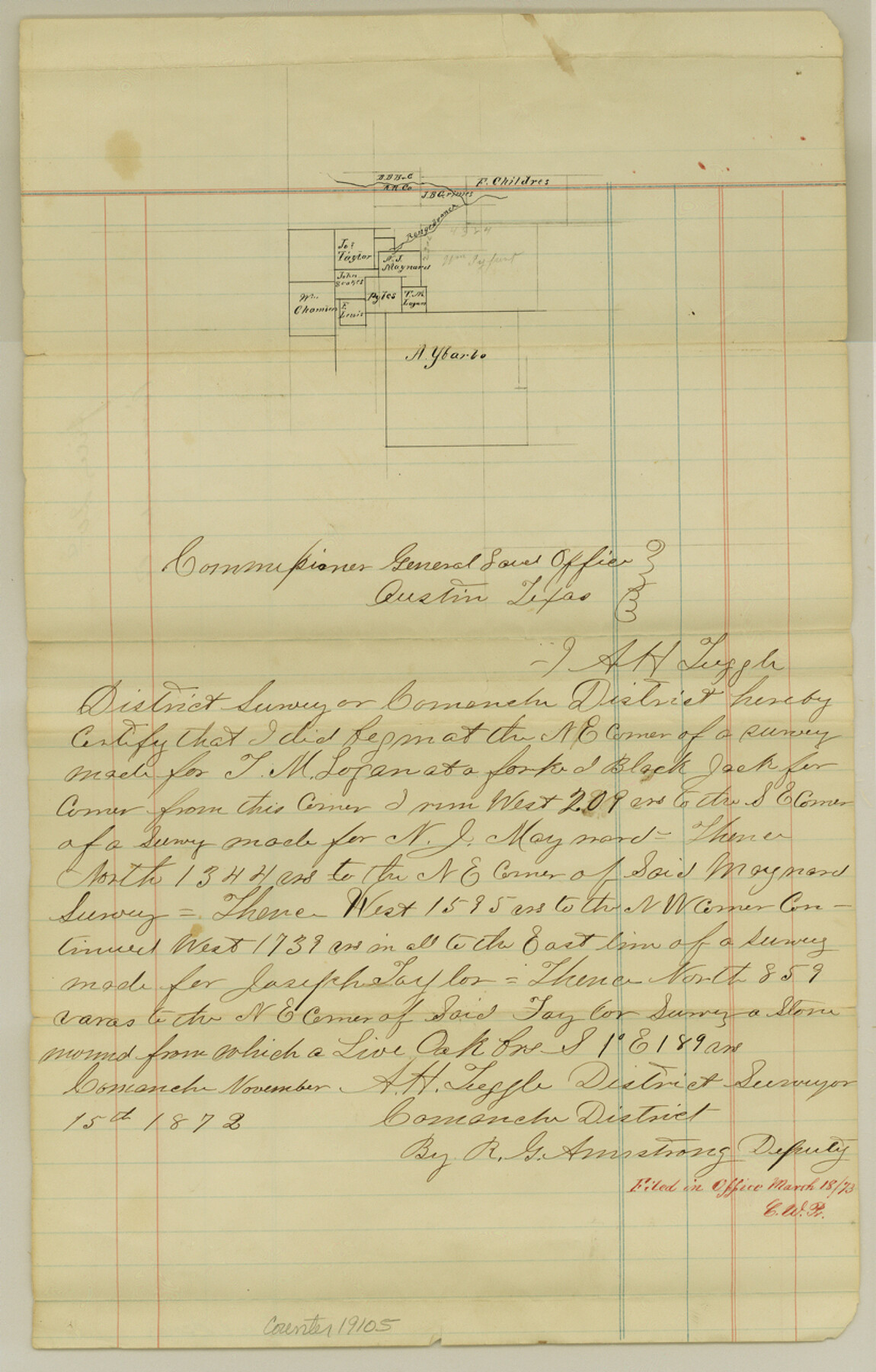
Comanche County Sketch File 20a
[Sketch of surveys around A. Ybarbo survey]
-
Map/Doc
19105
-
Collection
General Map Collection
-
Object Dates
1873/3/18 (File Date)
-
People and Organizations
A.H. Tuggle (Surveyor/Engineer)
-
Counties
Comanche
-
Subjects
Surveying Sketch File
-
Height x Width
12.9 x 8.2 inches
32.8 x 20.8 cm
-
Medium
paper, manuscript
-
Features
Range Branch
Part of: General Map Collection
Anderson County Working Sketch Graphic Index

Print $40.00
- Digital $50.00
Anderson County Working Sketch Graphic Index
1942
Size 52.0 x 48.3 inches
Map/Doc 76452
Reeves County Sketch File 25

Print $4.00
- Digital $50.00
Reeves County Sketch File 25
1873
Size 8.4 x 5.6 inches
Map/Doc 35224
Guadalupe County Sketch File 26

Print $4.00
- Digital $50.00
Guadalupe County Sketch File 26
1873
Size 10.2 x 8.2 inches
Map/Doc 24719
Stephens County Working Sketch 15

Print $20.00
- Digital $50.00
Stephens County Working Sketch 15
1963
Size 35.8 x 36.8 inches
Map/Doc 63958
Brazoria County NRC Article 33.136 Sketch 5

Print $22.00
- Digital $50.00
Brazoria County NRC Article 33.136 Sketch 5
2003
Size 24.2 x 35.4 inches
Map/Doc 80124
Flight Mission No. BRE-1P, Frame 121, Nueces County

Print $20.00
- Digital $50.00
Flight Mission No. BRE-1P, Frame 121, Nueces County
1956
Size 18.6 x 22.7 inches
Map/Doc 86687
Refugio County Working Sketch 18

Print $20.00
- Digital $50.00
Refugio County Working Sketch 18
2013
Size 24.0 x 29.3 inches
Map/Doc 93622
Parker County Working Sketch 13

Print $20.00
- Digital $50.00
Parker County Working Sketch 13
1978
Map/Doc 71463
Madison County Working Sketch 14

Print $4.00
- Digital $50.00
Madison County Working Sketch 14
Size 24.9 x 17.0 inches
Map/Doc 78204
Wichita County Sketch File 30

Print $32.00
- Digital $50.00
Wichita County Sketch File 30
1930
Size 8.8 x 8.3 inches
Map/Doc 40136
Gonzales County Rolled Sketch 1

Print $20.00
- Digital $50.00
Gonzales County Rolled Sketch 1
1917
Size 22.1 x 24.0 inches
Map/Doc 6028
Angelina County Sketch File 15g

Print $4.00
- Digital $50.00
Angelina County Sketch File 15g
1882
Size 10.9 x 8.4 inches
Map/Doc 12996
You may also like
Dallas County Boundary File 6a

Print $36.00
- Digital $50.00
Dallas County Boundary File 6a
Size 14.0 x 8.6 inches
Map/Doc 52189
Map of Europe designed to accompany Smith's Geography for Schools

Print $20.00
- Digital $50.00
Map of Europe designed to accompany Smith's Geography for Schools
1850
Size 9.8 x 12.1 inches
Map/Doc 93892
Crockett County Rolled Sketch CRV

Print $40.00
- Digital $50.00
Crockett County Rolled Sketch CRV
1925
Size 35.8 x 52.3 inches
Map/Doc 8693
Zavala County Sketch File A

Print $10.00
- Digital $50.00
Zavala County Sketch File A
1893
Size 8.7 x 7.9 inches
Map/Doc 41433
Coleman County

Print $40.00
- Digital $50.00
Coleman County
1945
Size 54.9 x 37.1 inches
Map/Doc 1803
Bailey County Sketch File 2a

Print $6.00
- Digital $50.00
Bailey County Sketch File 2a
1892
Size 13.0 x 8.3 inches
Map/Doc 13935
Van Zandt County Working Sketch 3

Print $20.00
- Digital $50.00
Van Zandt County Working Sketch 3
1923
Size 20.1 x 16.4 inches
Map/Doc 72252
Limestone County Sketch File 1

Print $4.00
- Digital $50.00
Limestone County Sketch File 1
Size 9.8 x 8.1 inches
Map/Doc 30155

Jasper County Sketch File 3

Print $6.00
- Digital $50.00
Jasper County Sketch File 3
Size 10.1 x 15.2 inches
Map/Doc 27768
[East Line, Hemphill County]
![90725, [East Line, Hemphill County], Twichell Survey Records](https://historictexasmaps.com/wmedia_w700/maps/90725-1.tif.jpg)
Print $2.00
- Digital $50.00
[East Line, Hemphill County]
Size 5.4 x 15.0 inches
Map/Doc 90725
Wharton County Rolled Sketch 6

Print $20.00
- Digital $50.00
Wharton County Rolled Sketch 6
1901
Size 23.7 x 30.0 inches
Map/Doc 8230