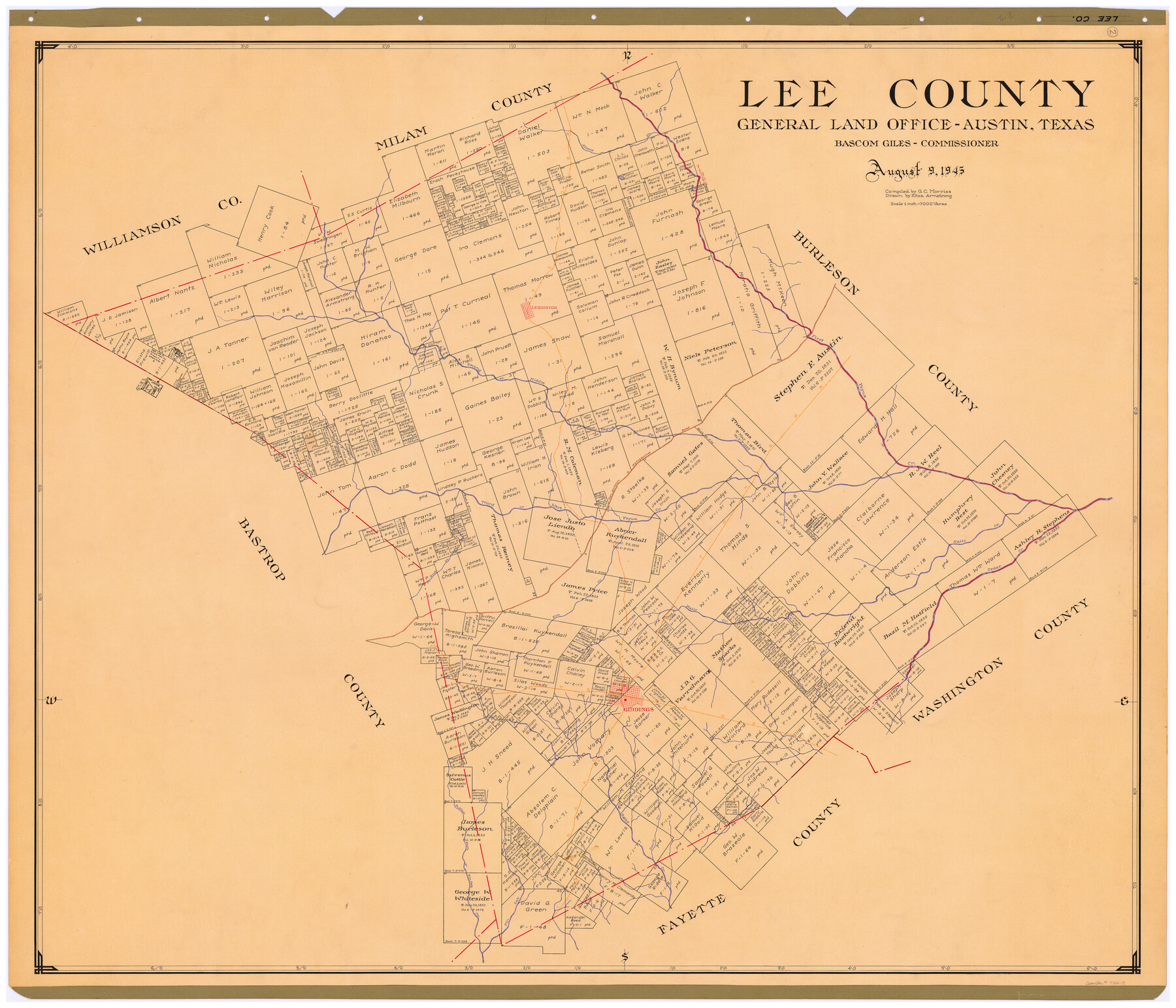
Lee County
-
Map/Doc
73217
-
Collection
General Map Collection
-
Object Dates
1945/8/9 (Creation Date)
-
People and Organizations
Texas General Land Office (Publisher)
Eltea Armstrong (Draftsman)
Bascom Giles (GLO Commissioner)
G.C. Morriss (Compiler)
-
Counties
Lee
-
Subjects
County
-
Height x Width
39.4 x 45.4 inches
100.1 x 115.3 cm
-
Comments
Hand lettered.
Note on reverse side: "Compilation completed August 9, 1945. Inking completed November 6, 1945. Tracing completed November 23, 1945. Placed in official use November 24, 1945. Replaced [on sticks] by copy June 20, 1946." -
Features
West Yegua Creek
Davis Creek
Pin Oak Creek
Buffalo Fork of Pin Oak Creek
Rabbs Creek
Giddings
Elm Creek
Bluff Creek
Cedar Creek
Nails Creek
Allans Creek
Third Yegua Creek
Nacogdoches Road
San Antonio Road
San Antonio and Nacogdoches Road
Middle Yegua Creek
Second Yegua Creek
First Yegua Creek
Lexington
T&NO
Part of: General Map Collection
Ochiltree County Boundary File 5c

Print $30.00
- Digital $50.00
Ochiltree County Boundary File 5c
Size 11.2 x 8.7 inches
Map/Doc 57699
Aransas County Working Sketch 4

Print $20.00
- Digital $50.00
Aransas County Working Sketch 4
1928
Size 37.4 x 31.8 inches
Map/Doc 67171
Hutchinson County Rolled Sketch 40

Print $20.00
- Digital $50.00
Hutchinson County Rolled Sketch 40
1981
Size 25.7 x 37.5 inches
Map/Doc 6299
[Surveys in the Nacogdoches District, Rusk County]
![339, [Surveys in the Nacogdoches District, Rusk County], General Map Collection](https://historictexasmaps.com/wmedia_w700/maps/339.tif.jpg)
Print $2.00
- Digital $50.00
[Surveys in the Nacogdoches District, Rusk County]
Size 6.0 x 8.2 inches
Map/Doc 339
Bell County Sketch File 19a

Print $4.00
- Digital $50.00
Bell County Sketch File 19a
Size 8.1 x 8.7 inches
Map/Doc 14404
Starr County Rolled Sketch 46A

Print $20.00
- Digital $50.00
Starr County Rolled Sketch 46A
1986
Size 17.9 x 34.4 inches
Map/Doc 7837
Coast Chart No. 210 Aransas Pass and Corpus Christi Bay with the coast to latitude 27° 12' Texas

Print $20.00
- Digital $50.00
Coast Chart No. 210 Aransas Pass and Corpus Christi Bay with the coast to latitude 27° 12' Texas
1913
Size 27.7 x 18.3 inches
Map/Doc 72798
Webb County Sketch File A1

Print $20.00
- Digital $50.00
Webb County Sketch File A1
1897
Size 20.3 x 20.3 inches
Map/Doc 12604
Trinity County Working Sketch 16

Print $20.00
- Digital $50.00
Trinity County Working Sketch 16
1978
Size 31.7 x 41.2 inches
Map/Doc 69465
Reagan County Working Sketch 42

Print $20.00
- Digital $50.00
Reagan County Working Sketch 42
1973
Size 19.9 x 37.0 inches
Map/Doc 71884
Fannin County Sketch File 8

Print $4.00
- Digital $50.00
Fannin County Sketch File 8
Size 8.7 x 13.3 inches
Map/Doc 22453
Map of San Patricio County

Print $40.00
- Digital $50.00
Map of San Patricio County
1896
Size 31.6 x 51.2 inches
Map/Doc 63018
You may also like
El Paso County Working Sketch 29

Print $40.00
- Digital $50.00
El Paso County Working Sketch 29
1967
Size 43.0 x 64.8 inches
Map/Doc 69051
Flight Mission No. CRC-3R, Frame 43, Chambers County

Print $20.00
- Digital $50.00
Flight Mission No. CRC-3R, Frame 43, Chambers County
1956
Size 18.5 x 22.3 inches
Map/Doc 84816
Zapata County Rolled Sketch 10A

Print $20.00
- Digital $50.00
Zapata County Rolled Sketch 10A
1912
Size 26.3 x 26.5 inches
Map/Doc 8312
[Sections 94 and 826-831 along Red River]
![93161, [Sections 94 and 826-831 along Red River], Twichell Survey Records](https://historictexasmaps.com/wmedia_w700/maps/93161-1.tif.jpg)
Print $40.00
- Digital $50.00
[Sections 94 and 826-831 along Red River]
Size 43.2 x 111.4 inches
Map/Doc 93161
Oldham County Boundary File 1b

Print $48.00
- Digital $50.00
Oldham County Boundary File 1b
Size 14.0 x 8.5 inches
Map/Doc 57747
Presidio County Rolled Sketch 53

Print $20.00
- Digital $50.00
Presidio County Rolled Sketch 53
1911
Size 23.9 x 18.2 inches
Map/Doc 7347
Sketch Showing Leagues Located in Deaf Smith Co. in lieu of Leagues in conflict with paid surveys

Print $2.00
- Digital $50.00
Sketch Showing Leagues Located in Deaf Smith Co. in lieu of Leagues in conflict with paid surveys
Size 8.2 x 15.7 inches
Map/Doc 90529
Lynn County Boundary File 11

Print $44.00
- Digital $50.00
Lynn County Boundary File 11
Size 14.1 x 8.7 inches
Map/Doc 56745
Roberts County Working Sketch 23

Print $20.00
- Digital $50.00
Roberts County Working Sketch 23
1979
Size 19.7 x 12.9 inches
Map/Doc 63549
Baylor County Working Sketch 7

Print $20.00
- Digital $50.00
Baylor County Working Sketch 7
1950
Size 31.4 x 24.0 inches
Map/Doc 67292
Gaines County Rolled Sketch 21

Print $20.00
- Digital $50.00
Gaines County Rolled Sketch 21
Size 29.0 x 24.9 inches
Map/Doc 5937
General Highway Map, Kenedy County, Texas

Print $20.00
General Highway Map, Kenedy County, Texas
1940
Size 18.4 x 24.9 inches
Map/Doc 79155