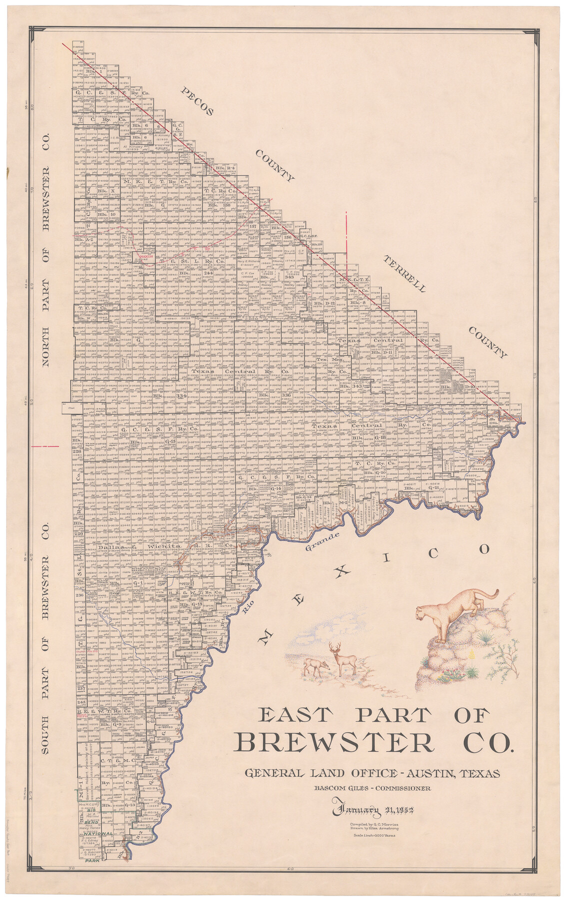
East Part of Brewster Co.
-
Map/Doc
73087
-
Collection
General Map Collection
-
Object Dates
1952/1/31 (Creation Date)
-
People and Organizations
Texas General Land Office (Publisher)
Eltea Armstrong (Draftsman)
Bascom Giles (GLO Commissioner)
G.C. Morriss (Compiler)
-
Counties
Brewster
-
Subjects
County
-
Height x Width
48.5 x 30.7 inches
123.2 x 78.0 cm
-
Comments
Hand lettered.
-
Features
Southern Pacific Railroad Company
Maxon
San Francisco Creek
Rio Grande
Reagan Canyon
Maravillas Creek
Big Bend National Park
Part of: General Map Collection
Uvalde County Rolled Sketch 22

Print $20.00
- Digital $50.00
Uvalde County Rolled Sketch 22
2002
Size 30.4 x 41.0 inches
Map/Doc 78656
Lubbock County Boundary File 8

Print $46.00
- Digital $50.00
Lubbock County Boundary File 8
Size 7.3 x 8.7 inches
Map/Doc 56525
Jim Wells County Working Sketch 9

Print $20.00
- Digital $50.00
Jim Wells County Working Sketch 9
1948
Size 34.1 x 38.9 inches
Map/Doc 66607
Wichita County Working Sketch 3

Print $20.00
- Digital $50.00
Wichita County Working Sketch 3
1913
Size 22.2 x 15.6 inches
Map/Doc 72512
Bexar County Sketch File 46

Print $40.00
- Digital $50.00
Bexar County Sketch File 46
1888
Size 24.7 x 22.6 inches
Map/Doc 10924
Map of Runnels County

Print $20.00
- Digital $50.00
Map of Runnels County
1887
Size 24.7 x 19.9 inches
Map/Doc 4000
Flight Mission No. CLL-3N, Frame 8, Willacy County

Print $20.00
- Digital $50.00
Flight Mission No. CLL-3N, Frame 8, Willacy County
1954
Size 18.5 x 22.2 inches
Map/Doc 87074
Val Verde County Sketch File 57

Print $28.00
- Digital $50.00
Val Verde County Sketch File 57
2009
Size 11.0 x 8.5 inches
Map/Doc 89235
Cooke County Sketch File 25

Print $4.00
- Digital $50.00
Cooke County Sketch File 25
1872
Size 8.2 x 6.8 inches
Map/Doc 19275
Uvalde County Working Sketch 24

Print $20.00
- Digital $50.00
Uvalde County Working Sketch 24
1954
Size 21.7 x 23.3 inches
Map/Doc 72094
Motley County Sketch File A (S)

Print $40.00
- Digital $50.00
Motley County Sketch File A (S)
Size 10.7 x 20.4 inches
Map/Doc 32155
Belton and Stillhouse Hollow Reservoirs (Verso)

Belton and Stillhouse Hollow Reservoirs (Verso)
1972
Size 29.3 x 22.7 inches
Map/Doc 94173
You may also like
[Block C41 and vicinity]
![92624, [Block C41 and vicinity], Twichell Survey Records](https://historictexasmaps.com/wmedia_w700/maps/92624-1.tif.jpg)
Print $20.00
- Digital $50.00
[Block C41 and vicinity]
1951
Size 24.8 x 19.0 inches
Map/Doc 92624
United States - Gulf Coast - From Latitude 26° 33' to the Rio Grande Texas

Print $20.00
- Digital $50.00
United States - Gulf Coast - From Latitude 26° 33' to the Rio Grande Texas
1918
Size 27.7 x 18.2 inches
Map/Doc 72850
General Highway Map, Kenedy County, Texas

Print $20.00
General Highway Map, Kenedy County, Texas
1940
Size 18.4 x 24.9 inches
Map/Doc 79155
Milam District

Print $20.00
- Digital $50.00
Milam District
1854
Size 30.2 x 18.9 inches
Map/Doc 3859
DeWitt County Rolled Sketch 1

Print $20.00
- Digital $50.00
DeWitt County Rolled Sketch 1
1940
Size 40.5 x 39.5 inches
Map/Doc 8777
Presidio County Working Sketch 3

Print $20.00
- Digital $50.00
Presidio County Working Sketch 3
1914
Size 21.5 x 15.9 inches
Map/Doc 71677
Flight Mission No. DCL-6C, Frame 27, Kenedy County

Print $20.00
- Digital $50.00
Flight Mission No. DCL-6C, Frame 27, Kenedy County
1943
Size 18.7 x 22.4 inches
Map/Doc 85884
Nueces County Rolled Sketch 68

Print $20.00
- Digital $50.00
Nueces County Rolled Sketch 68
1980
Size 19.9 x 25.4 inches
Map/Doc 6919
Sulphur River and Cut Hand Creek, Hardison Lake Sheet

Print $20.00
- Digital $50.00
Sulphur River and Cut Hand Creek, Hardison Lake Sheet
1919
Size 22.5 x 24.2 inches
Map/Doc 65177
Terry County Rolled Sketch 6

Print $20.00
- Digital $50.00
Terry County Rolled Sketch 6
1944
Size 36.5 x 43.7 inches
Map/Doc 9996
Flight Mission No. DAG-22K, Frame 88, Matagorda County

Print $20.00
- Digital $50.00
Flight Mission No. DAG-22K, Frame 88, Matagorda County
1953
Size 18.6 x 22.4 inches
Map/Doc 86472
Midland County Working Sketch 15

Print $20.00
- Digital $50.00
Midland County Working Sketch 15
1953
Size 27.2 x 28.6 inches
Map/Doc 70995