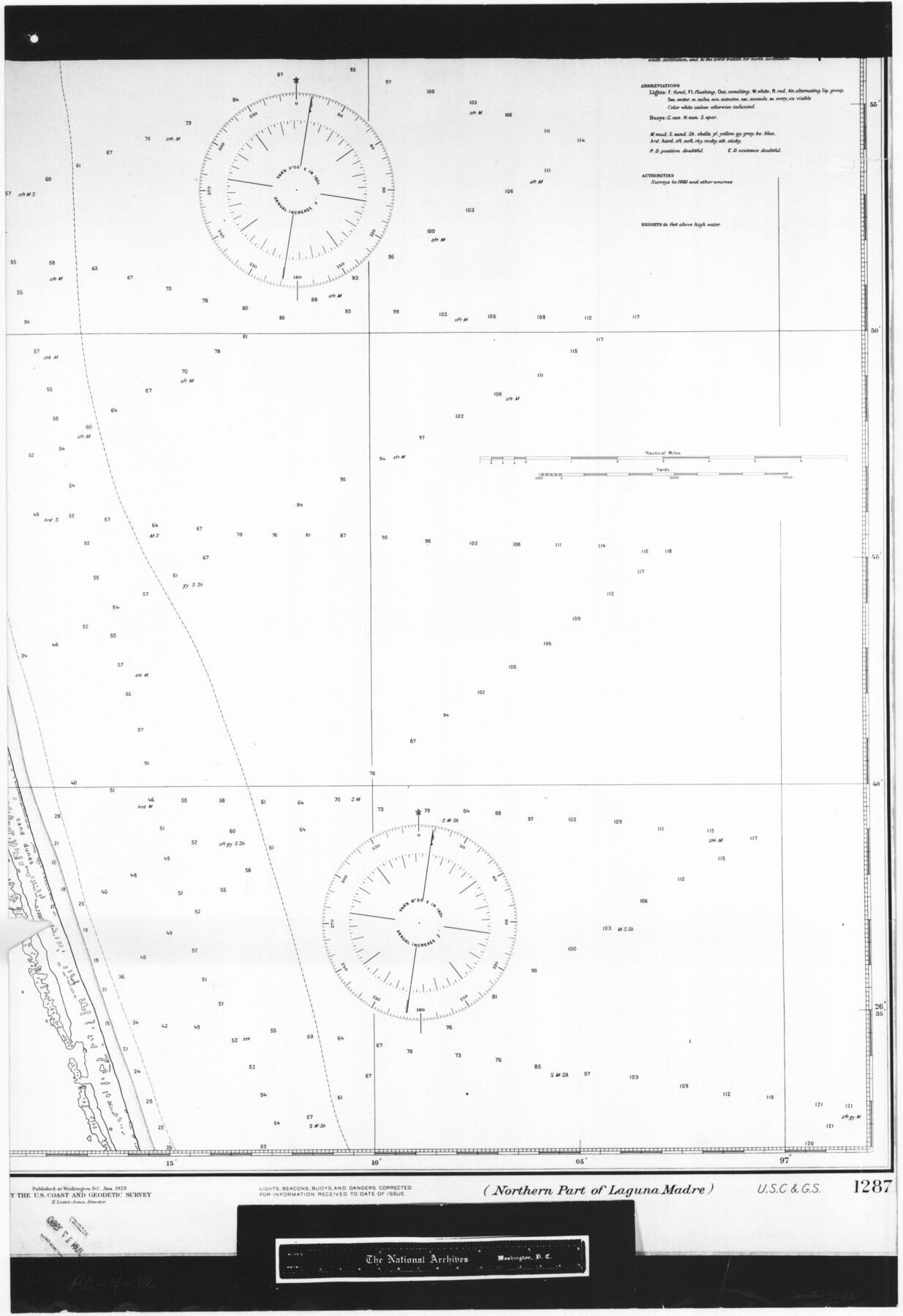
United States - Gulf Coast Texas - Northern part of Laguna Madre
RL-4-1a
-
Map/Doc
72931
-
Collection
General Map Collection
-
Object Dates
1923 (Creation Date)
-
People and Organizations
U. S. Coast and Geodetic Survey (Publisher)
U. S. Coast and Geodetic Survey (Author)
-
Subjects
Nautical Charts
-
Height x Width
26.6 x 18.3 inches
67.6 x 46.5 cm
-
Comments
B/W photostat copy from National Archives in multiple pieces.
Part of: General Map Collection
Southern Part of Laguna Madre

Print $20.00
- Digital $50.00
Southern Part of Laguna Madre
1975
Size 45.1 x 35.0 inches
Map/Doc 73545
Texas & Pacific Ry Reserve west of the Pecos River

Print $40.00
- Digital $50.00
Texas & Pacific Ry Reserve west of the Pecos River
1880
Size 43.9 x 90.6 inches
Map/Doc 3047
Glasscock County Working Sketch Graphic Index

Print $20.00
- Digital $50.00
Glasscock County Working Sketch Graphic Index
1933
Size 43.7 x 37.0 inches
Map/Doc 76554
El Paso County Rolled Sketch 23

Print $20.00
- Digital $50.00
El Paso County Rolled Sketch 23
1888
Size 46.2 x 38.1 inches
Map/Doc 8856
Stonewall County Rolled Sketch 11

Print $20.00
- Digital $50.00
Stonewall County Rolled Sketch 11
Size 33.2 x 28.1 inches
Map/Doc 7867
Kent County Boundary File 12

Print $30.00
- Digital $50.00
Kent County Boundary File 12
Size 10.5 x 8.2 inches
Map/Doc 55897
Haskell County Sketch File 3

Print $8.00
- Digital $50.00
Haskell County Sketch File 3
Size 9.8 x 8.8 inches
Map/Doc 26121
Guadalupe County Sketch File 23

Print $22.00
- Digital $50.00
Guadalupe County Sketch File 23
1859
Size 25.5 x 19.0 inches
Map/Doc 11592
Map of Prison Property in Walker County, Texas

Print $20.00
- Digital $50.00
Map of Prison Property in Walker County, Texas
Size 37.6 x 42.9 inches
Map/Doc 62993
Cass County Working Sketch 47a

Print $20.00
- Digital $50.00
Cass County Working Sketch 47a
1991
Size 29.5 x 39.5 inches
Map/Doc 67950
Leon County Rolled Sketch 14A

Print $200.00
- Digital $50.00
Leon County Rolled Sketch 14A
1975
Size 16.5 x 35.5 inches
Map/Doc 46535
Mexico und Texas

Print $20.00
- Digital $50.00
Mexico und Texas
1851
Size 15.8 x 19.1 inches
Map/Doc 93714
You may also like
Plat showing proposed counties to be taken from Zapata, Starr & Hidalgo Counties

Print $20.00
- Digital $50.00
Plat showing proposed counties to be taken from Zapata, Starr & Hidalgo Counties
1911
Size 24.8 x 27.0 inches
Map/Doc 2478
Jefferson County Rolled Sketch 23

Print $20.00
- Digital $50.00
Jefferson County Rolled Sketch 23
1938
Size 45.9 x 33.3 inches
Map/Doc 9289
Motley County Sketch File 3 (N)

Print $22.00
- Digital $50.00
Motley County Sketch File 3 (N)
Size 9.1 x 13.0 inches
Map/Doc 31998
La Salle County Working Sketch 34

Print $20.00
- Digital $50.00
La Salle County Working Sketch 34
1956
Size 18.8 x 26.2 inches
Map/Doc 70335
Intracoastal Waterway - Gibbstown to Port Arthur

Print $20.00
- Digital $50.00
Intracoastal Waterway - Gibbstown to Port Arthur
1961
Size 26.6 x 38.7 inches
Map/Doc 69833
Harris County Working Sketch 7

Print $20.00
- Digital $50.00
Harris County Working Sketch 7
1900
Size 34.2 x 28.6 inches
Map/Doc 65899
Topographical Map of the Rio Grande, Sheet No. 2

Print $20.00
- Digital $50.00
Topographical Map of the Rio Grande, Sheet No. 2
1912
Map/Doc 89526
Reagan County Sketch File 26

Print $20.00
- Digital $50.00
Reagan County Sketch File 26
1948
Size 16.9 x 28.7 inches
Map/Doc 12223
Mitchell County Boundary File 66a

Print $11.00
- Digital $50.00
Mitchell County Boundary File 66a
Size 12.6 x 8.3 inches
Map/Doc 57378
El Paso County Rolled Sketch 50

Print $40.00
- Digital $50.00
El Paso County Rolled Sketch 50
Size 19.7 x 76.0 inches
Map/Doc 76430
Map of Grimes County

Print $20.00
- Digital $50.00
Map of Grimes County
1858
Size 29.1 x 21.4 inches
Map/Doc 3605
Flight Mission No. BRA-16M, Frame 66, Jefferson County

Print $20.00
- Digital $50.00
Flight Mission No. BRA-16M, Frame 66, Jefferson County
1953
Size 18.6 x 22.3 inches
Map/Doc 85683