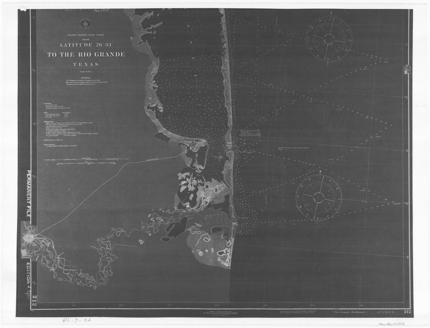
United States - Gulf Coast - From Latitude 26° 33' to the Rio Grande Texas
RL-3-3d
-
Map/Doc
72848
-
Collection
General Map Collection
-
Object Dates
1918 (Creation Date)
-
People and Organizations
U. S. Coastal and Geodetic Survey (Publisher)
-
Subjects
Nautical Charts
-
Height x Width
18.4 x 24.1 inches
46.7 x 61.2 cm
-
Comments
B/W photostat copy from National Archives in multiple pieces.
Part of: General Map Collection
Webb County Sketch File X

Print $32.00
- Digital $50.00
Webb County Sketch File X
1908
Size 11.2 x 9.0 inches
Map/Doc 39701
Ochiltree County Boundary File 5a

Print $10.00
- Digital $50.00
Ochiltree County Boundary File 5a
Size 13.7 x 8.7 inches
Map/Doc 57692
McMullen County Sketch File 21

Print $4.00
- Digital $50.00
McMullen County Sketch File 21
1876
Size 10.0 x 8.0 inches
Map/Doc 31375
Amistad International Reservoir on Rio Grande 66

Print $20.00
- Digital $50.00
Amistad International Reservoir on Rio Grande 66
1949
Size 28.5 x 39.6 inches
Map/Doc 73351
Harris County Sketch File 17

Print $4.00
- Digital $50.00
Harris County Sketch File 17
1860
Size 5.8 x 5.6 inches
Map/Doc 25361
Zavala County

Print $20.00
- Digital $50.00
Zavala County
1977
Size 36.6 x 41.6 inches
Map/Doc 77468
Pecos County Working Sketch 91b

Print $40.00
- Digital $50.00
Pecos County Working Sketch 91b
1965
Size 78.9 x 32.7 inches
Map/Doc 71564
Galveston Bay and Approaches

Print $20.00
- Digital $50.00
Galveston Bay and Approaches
1957
Size 43.6 x 32.7 inches
Map/Doc 69877
Webb County Rolled Sketch 17

Print $20.00
- Digital $50.00
Webb County Rolled Sketch 17
1915
Size 16.7 x 14.7 inches
Map/Doc 8180
Index sheet to accompany map of survey for connecting the inland waters along margin of the Gulf of Mexico from Donaldsonville in Louisiana to the Rio Grande River in Texas

Print $20.00
- Digital $50.00
Index sheet to accompany map of survey for connecting the inland waters along margin of the Gulf of Mexico from Donaldsonville in Louisiana to the Rio Grande River in Texas
Size 18.2 x 27.4 inches
Map/Doc 72690
Hutchinson County Boundary File 1

Print $82.00
- Digital $50.00
Hutchinson County Boundary File 1
Size 8.7 x 38.3 inches
Map/Doc 55292
Lynn County Boundary File 2

Print $6.00
- Digital $50.00
Lynn County Boundary File 2
Size 11.1 x 8.7 inches
Map/Doc 56620
You may also like

[East Neches River]
![90420, [East Neches River], Twichell Survey Records](https://historictexasmaps.com/wmedia_w700/maps/90420-1.tif.jpg)
Print $20.00
- Digital $50.00
[East Neches River]
Size 25.8 x 29.3 inches
Map/Doc 90420
Brazoria County Rolled Sketch 31

Print $20.00
- Digital $50.00
Brazoria County Rolled Sketch 31
Size 25.6 x 45.9 inches
Map/Doc 5169
Dallas County Boundary File 1

Print $62.00
- Digital $50.00
Dallas County Boundary File 1
Size 4.1 x 3.7 inches
Map/Doc 52084
University Lands, Blocks 1-13 & Block 58, Crockett, Reagan & Upton Counties

Print $20.00
- Digital $50.00
University Lands, Blocks 1-13 & Block 58, Crockett, Reagan & Upton Counties
1936
Size 36.9 x 42.0 inches
Map/Doc 2409
Duval County Sketch File 15

Print $4.00
- Digital $50.00
Duval County Sketch File 15
Size 12.0 x 9.0 inches
Map/Doc 21309
Castro County Sketch File 4d

Print $4.00
- Digital $50.00
Castro County Sketch File 4d
Size 13.6 x 8.8 inches
Map/Doc 17471
[Map of Denton County]
![4529, [Map of Denton County], General Map Collection](https://historictexasmaps.com/wmedia_w700/maps/4529-1.tif.jpg)
Print $20.00
- Digital $50.00
[Map of Denton County]
1853
Size 24.5 x 29.1 inches
Map/Doc 4529
Eastland County Working Sketch 36

Print $20.00
- Digital $50.00
Eastland County Working Sketch 36
1963
Size 24.0 x 40.0 inches
Map/Doc 68817
Bailey County, Texas

Print $20.00
- Digital $50.00
Bailey County, Texas
Size 30.1 x 41.8 inches
Map/Doc 92528
Donley County Sketch File 5a

Print $6.00
- Digital $50.00
Donley County Sketch File 5a
Size 11.0 x 12.6 inches
Map/Doc 21268
Jefferson County Working Sketch 12

Print $20.00
- Digital $50.00
Jefferson County Working Sketch 12
1947
Size 29.9 x 39.4 inches
Map/Doc 66555