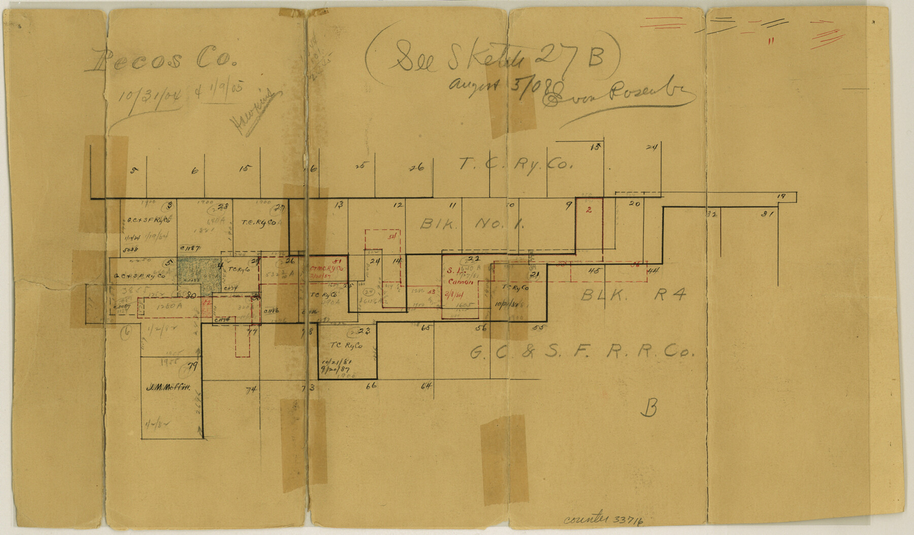
Pecos County Sketch File 35
[Sketch of T. & C. RR. Co. Block 1 and G. C. & S. F. RR. Co. Block R4]
-
Map/Doc
33716
-
Collection
General Map Collection
-
Counties
Pecos Brewster
-
Subjects
Surveying Sketch File
-
Height x Width
8.9 x 15.3 inches
22.6 x 38.9 cm
-
Medium
paper, manuscript
Part of: General Map Collection
[Surveys along the Colorado and Navidad Rivers]
![60, [Surveys along the Colorado and Navidad Rivers], General Map Collection](https://historictexasmaps.com/wmedia_w700/maps/60.tif.jpg)
Print $20.00
- Digital $50.00
[Surveys along the Colorado and Navidad Rivers]
1840
Size 28.6 x 22.5 inches
Map/Doc 60
Medina County Working Sketch 21

Print $20.00
- Digital $50.00
Medina County Working Sketch 21
1982
Size 18.1 x 23.3 inches
Map/Doc 70936
Burleson County

Print $20.00
- Digital $50.00
Burleson County
1920
Size 38.0 x 45.0 inches
Map/Doc 4790
San Patricio County Working Sketch 2

Print $20.00
- Digital $50.00
San Patricio County Working Sketch 2
1911
Size 18.6 x 15.1 inches
Map/Doc 63764
Part of Laguna Madre from Mosquito Trangulation Station to Sand Triangulation Station

Print $40.00
- Digital $50.00
Part of Laguna Madre from Mosquito Trangulation Station to Sand Triangulation Station
1881
Size 34.5 x 54.6 inches
Map/Doc 73486
Controlled Mosaic by Jack Amman Photogrammetric Engineers, Inc - Sheet 28

Print $20.00
- Digital $50.00
Controlled Mosaic by Jack Amman Photogrammetric Engineers, Inc - Sheet 28
1954
Size 20.0 x 24.0 inches
Map/Doc 83481
Schleicher County Rolled Sketch 9

Print $20.00
- Digital $50.00
Schleicher County Rolled Sketch 9
Size 22.7 x 22.0 inches
Map/Doc 7751
Clarkson's City Map of Port Aransas

Print $20.00
- Digital $50.00
Clarkson's City Map of Port Aransas
Size 18.5 x 26.5 inches
Map/Doc 3040
Jack County Sketch File 13

Print $4.00
- Digital $50.00
Jack County Sketch File 13
Size 10.3 x 8.0 inches
Map/Doc 27537
Navigation Maps of Gulf Intracoastal Waterway, Port Arthur to Brownsville, Texas

Print $4.00
- Digital $50.00
Navigation Maps of Gulf Intracoastal Waterway, Port Arthur to Brownsville, Texas
1951
Size 16.7 x 21.6 inches
Map/Doc 65447
Red River County Working Sketch 30

Print $20.00
- Digital $50.00
Red River County Working Sketch 30
1962
Size 25.2 x 22.8 inches
Map/Doc 72013
San Jacinto County

Print $40.00
- Digital $50.00
San Jacinto County
1942
Size 49.7 x 44.1 inches
Map/Doc 95633
You may also like
Karte von Texas entworfen nach den Vermessungen welche in den Acten der General Land Office der Republic liegen bis zum Jahr 1839

Print $20.00
- Digital $50.00
Karte von Texas entworfen nach den Vermessungen welche in den Acten der General Land Office der Republic liegen bis zum Jahr 1839
1845
Size 18.6 x 14.1 inches
Map/Doc 96629
Austin County Boundary File 5a

Print $6.00
- Digital $50.00
Austin County Boundary File 5a
Size 14.1 x 8.7 inches
Map/Doc 50252
[Right of Way & Track Map, The Texas & Pacific Ry. Co. Main Line]
![64674, [Right of Way & Track Map, The Texas & Pacific Ry. Co. Main Line], General Map Collection](https://historictexasmaps.com/wmedia_w700/maps/64674.tif.jpg)
Print $20.00
- Digital $50.00
[Right of Way & Track Map, The Texas & Pacific Ry. Co. Main Line]
Size 11.1 x 18.6 inches
Map/Doc 64674
Henderson County Working Sketch 32

Print $40.00
- Digital $50.00
Henderson County Working Sketch 32
1963
Size 56.5 x 50.0 inches
Map/Doc 66165
Jack County Rolled Sketch 2

Print $20.00
- Digital $50.00
Jack County Rolled Sketch 2
1972
Size 31.3 x 29.0 inches
Map/Doc 6332
Duval County Sketch File 27

Print $6.00
- Digital $50.00
Duval County Sketch File 27
1919
Size 11.0 x 11.8 inches
Map/Doc 21334
El Paso County Working Sketch 6

Print $20.00
- Digital $50.00
El Paso County Working Sketch 6
1928
Size 25.4 x 16.7 inches
Map/Doc 69028
[Stone, Kyle and Kyle Block M6]
![90403, [Stone, Kyle and Kyle Block M6], Twichell Survey Records](https://historictexasmaps.com/wmedia_w700/maps/90403-1.tif.jpg)
Print $2.00
- Digital $50.00
[Stone, Kyle and Kyle Block M6]
1904
Size 12.7 x 9.0 inches
Map/Doc 90403
Hutchinson County Rolled Sketch 44-18

Print $20.00
- Digital $50.00
Hutchinson County Rolled Sketch 44-18
2002
Size 24.0 x 36.0 inches
Map/Doc 77554
Potter County Sketch File 14

Print $20.00
- Digital $50.00
Potter County Sketch File 14
Size 16.5 x 22.5 inches
Map/Doc 12200
Wichita County Working Sketch 26

Print $20.00
- Digital $50.00
Wichita County Working Sketch 26
1981
Size 13.1 x 21.0 inches
Map/Doc 72536
Archer County Sketch File 18

Print $40.00
- Digital $50.00
Archer County Sketch File 18
Size 23.9 x 13.0 inches
Map/Doc 10828