Hutchinson County Rolled Sketch 42
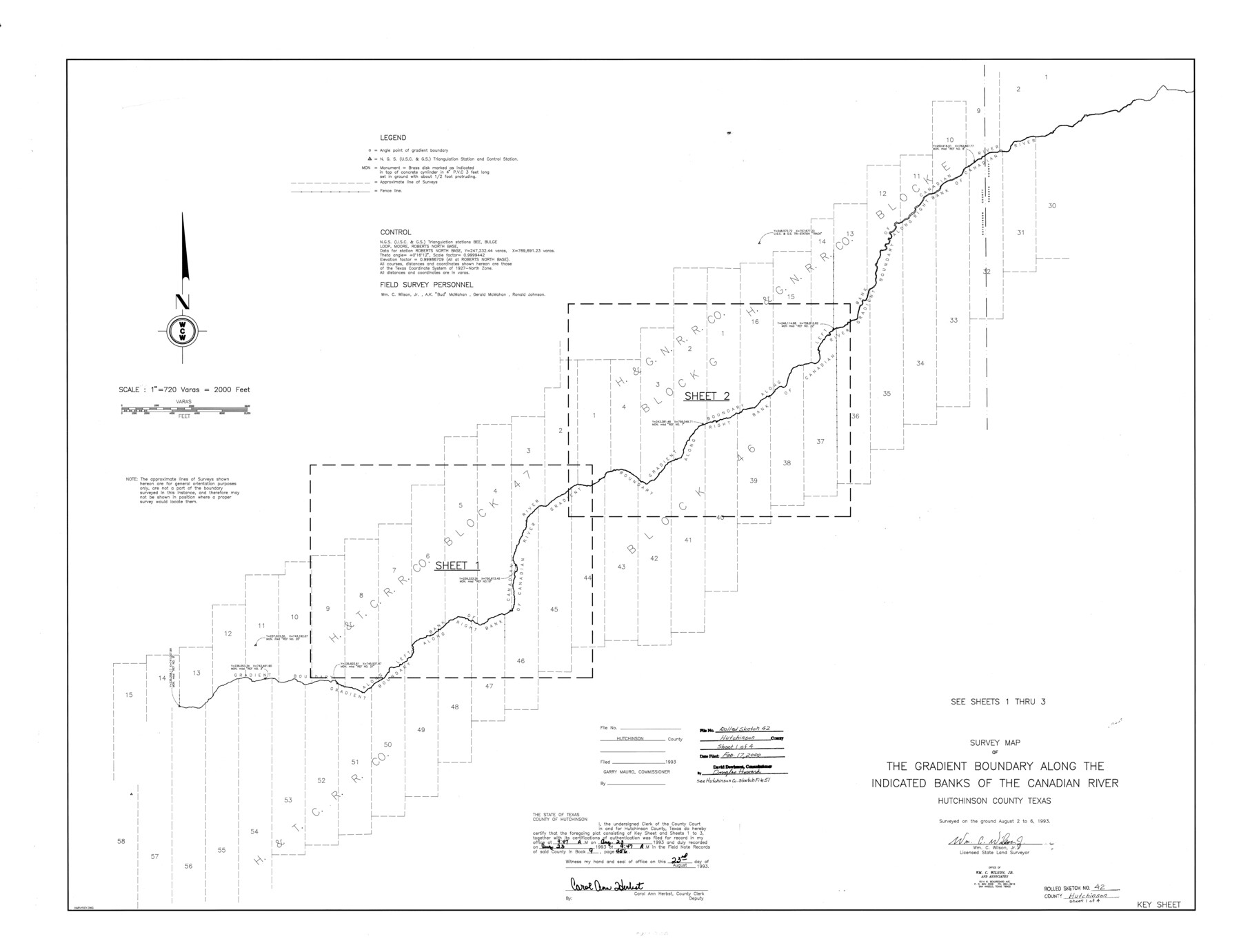
Survey map of the Gradient Boundary along the indicated banks of the Canadian River [Index Map]
-
Map/Doc
6307
-
Collection
General Map Collection
-
Object Dates
1993/8/6 (Survey Date)
2000/2/17 (File Date)
-
People and Organizations
Wm. C. Wilson, Jr. (Surveyor/Engineer)
A.K. "Bud" McMahan (Chainman/Field Personnel)
Gerald McMahan (Chainman/Field Personnel)
Ronald Johnson (Chainman/Field Personnel)
-
Counties
Hutchinson
-
Subjects
Surveying Rolled Sketch
-
Height x Width
38.0 x 49.5 inches
96.5 x 125.7 cm
-
Medium
mylar, print
-
Scale
1" = 720 varas
-
Comments
Index map. See Hutchinson County Sketch File 51 (27440) for field notes.
Related maps
Hutchinson County Sketch File 51

Print $18.00
- Digital $50.00
Hutchinson County Sketch File 51
1993
Size 14.2 x 8.6 inches
Map/Doc 27440
Part of: General Map Collection
Chambers County Rolled Sketch 34

Print $40.00
- Digital $50.00
Chambers County Rolled Sketch 34
1956
Size 50.0 x 85.8 inches
Map/Doc 73571
Trinity County Sketch File 20

Print $20.00
- Digital $50.00
Trinity County Sketch File 20
Size 21.3 x 27.9 inches
Map/Doc 12485
Coke County Rolled Sketch 14

Print $20.00
- Digital $50.00
Coke County Rolled Sketch 14
Size 26.8 x 18.9 inches
Map/Doc 5514
Flight Mission No. CRC-4R, Frame 64, Chambers County

Print $20.00
- Digital $50.00
Flight Mission No. CRC-4R, Frame 64, Chambers County
1956
Size 18.7 x 22.3 inches
Map/Doc 84868
Geographical, Statistical, and Historical Map of Mexico

Print $20.00
- Digital $50.00
Geographical, Statistical, and Historical Map of Mexico
1822
Size 18.0 x 22.4 inches
Map/Doc 95694
Culberson County Rolled Sketch 27

Print $20.00
- Digital $50.00
Culberson County Rolled Sketch 27
1922
Size 26.8 x 34.9 inches
Map/Doc 5656
Nueces County NRC Article 33.136 Sketch 10

Print $36.00
- Digital $50.00
Nueces County NRC Article 33.136 Sketch 10
2004
Size 23.9 x 35.9 inches
Map/Doc 83526
Throckmorton County Boundary File 1

Print $12.00
- Digital $50.00
Throckmorton County Boundary File 1
Size 8.8 x 7.8 inches
Map/Doc 59258
Webb County Working Sketch 9

Print $20.00
- Digital $50.00
Webb County Working Sketch 9
1911
Size 17.2 x 30.8 inches
Map/Doc 72374
Starr County Working Sketch 2

Print $20.00
- Digital $50.00
Starr County Working Sketch 2
1916
Size 12.0 x 37.0 inches
Map/Doc 63918
Winkler County Sketch File 16

Print $30.00
- Digital $50.00
Winkler County Sketch File 16
1929
Size 14.2 x 8.7 inches
Map/Doc 40493
Montague County Working Sketch 14

Print $20.00
- Digital $50.00
Montague County Working Sketch 14
1940
Size 28.4 x 17.9 inches
Map/Doc 71080
You may also like
Montgomery County Sketch File 40

Print $8.00
- Digital $50.00
Montgomery County Sketch File 40
1914
Size 11.3 x 8.8 inches
Map/Doc 31925
Andrews County

Print $40.00
- Digital $50.00
Andrews County
1951
Size 43.0 x 54.4 inches
Map/Doc 77199
Henderson County Boundary File 2b

Print $14.00
- Digital $50.00
Henderson County Boundary File 2b
Size 14.1 x 8.7 inches
Map/Doc 54662
Bosque County Sketch File 25

Print $4.00
- Digital $50.00
Bosque County Sketch File 25
Size 12.7 x 8.1 inches
Map/Doc 14809

Val Verde County Working Sketch 116

Print $20.00
- Digital $50.00
Val Verde County Working Sketch 116
2003
Size 38.4 x 34.8 inches
Map/Doc 78493
Flight Mission No. DJV-3P, Frame 13, Ellis County

Print $20.00
- Digital $50.00
Flight Mission No. DJV-3P, Frame 13, Ellis County
1956
Size 18.6 x 22.2 inches
Map/Doc 84975
The Republic County of Montgomery. December 31, 1838

Print $20.00
The Republic County of Montgomery. December 31, 1838
2020
Size 19.9 x 21.7 inches
Map/Doc 96236
Flight Mission No. CUG-1P, Frame 41, Kleberg County

Print $20.00
- Digital $50.00
Flight Mission No. CUG-1P, Frame 41, Kleberg County
1956
Size 18.7 x 22.3 inches
Map/Doc 86119
Map of Houston County

Print $40.00
- Digital $50.00
Map of Houston County
1841
Size 58.6 x 32.2 inches
Map/Doc 1952
Map of Erath County

Print $40.00
- Digital $50.00
Map of Erath County
1896
Size 48.6 x 45.1 inches
Map/Doc 66821
Flight Mission No. BQY-15M, Frame 3, Harris County

Print $20.00
- Digital $50.00
Flight Mission No. BQY-15M, Frame 3, Harris County
1953
Size 18.7 x 22.5 inches
Map/Doc 85301