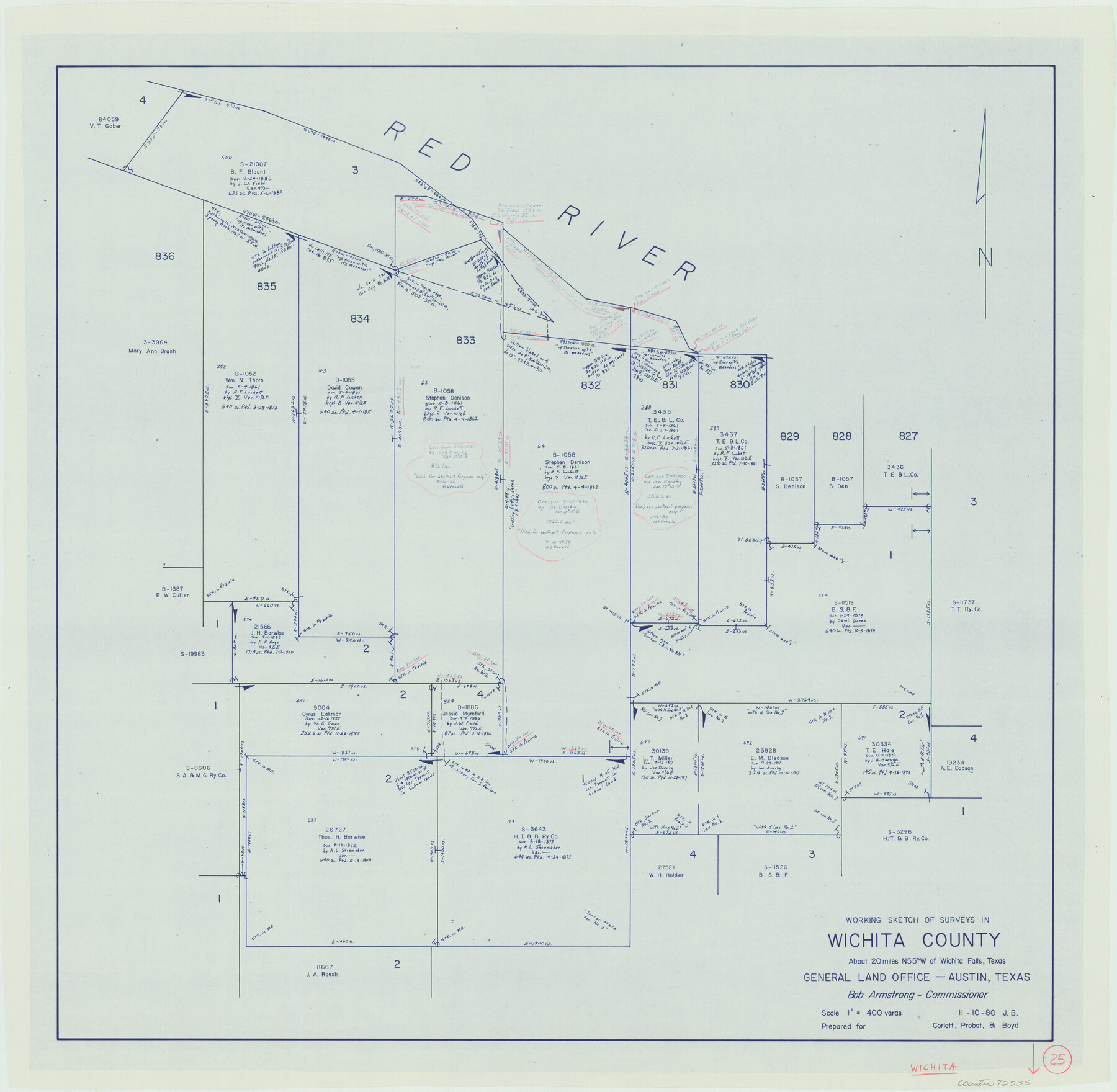
Wichita County Working Sketch 25
-
Map/Doc
72535
-
Collection
General Map Collection
-
Object Dates
11/10/1980 (Creation Date)
-
People and Organizations
Jana Brod (Draftsman)
-
Counties
Wichita
-
Subjects
Surveying Working Sketch
-
Height x Width
27.1 x 27.7 inches
68.8 x 70.4 cm
-
Scale
1" = 400 varas
Part of: General Map Collection
Lubbock County Working Sketch 2

Print $20.00
- Digital $50.00
Lubbock County Working Sketch 2
Size 31.7 x 21.4 inches
Map/Doc 70661

Wichita County Working Sketch 13

Print $20.00
- Digital $50.00
Wichita County Working Sketch 13
1921
Size 16.5 x 32.8 inches
Map/Doc 72523
Presidio County Working Sketch 129

Print $20.00
- Digital $50.00
Presidio County Working Sketch 129
1988
Size 24.0 x 24.7 inches
Map/Doc 71807
Midland County Working Sketch 18

Print $40.00
- Digital $50.00
Midland County Working Sketch 18
1956
Size 26.5 x 49.5 inches
Map/Doc 70998
United States - Gulf Coast - Padre I. and Laguna Madre Lat. 27° 12' to Lat. 26° 33' Texas

Print $20.00
- Digital $50.00
United States - Gulf Coast - Padre I. and Laguna Madre Lat. 27° 12' to Lat. 26° 33' Texas
1913
Size 26.8 x 18.4 inches
Map/Doc 72817
Childress County Rolled Sketch 5A

Print $20.00
- Digital $50.00
Childress County Rolled Sketch 5A
Size 32.9 x 21.9 inches
Map/Doc 5440
Galveston County Rolled Sketch 30

Print $20.00
- Digital $50.00
Galveston County Rolled Sketch 30
1979
Size 28.0 x 39.8 inches
Map/Doc 5964
Palo Pinto County Working Sketch 15

Print $20.00
- Digital $50.00
Palo Pinto County Working Sketch 15
1971
Size 26.4 x 30.8 inches
Map/Doc 71398
Val Verde County Sketch File 6a

Print $14.00
- Digital $50.00
Val Verde County Sketch File 6a
1895
Size 7.4 x 8.7 inches
Map/Doc 39191
Fannin County Working Sketch 9

Print $20.00
- Digital $50.00
Fannin County Working Sketch 9
1973
Size 28.1 x 21.9 inches
Map/Doc 69163
Montgomery County Rolled Sketch 34

Print $20.00
- Digital $50.00
Montgomery County Rolled Sketch 34
1954
Size 32.1 x 28.4 inches
Map/Doc 6811
You may also like
Bissell's railway junction point map of Texas / especially designed and adapted for the computation of shortline distances in the application of freight rates promulgated by the Railroad Commission of Texas.

Print $20.00
Bissell's railway junction point map of Texas / especially designed and adapted for the computation of shortline distances in the application of freight rates promulgated by the Railroad Commission of Texas.
1891
Size 31.5 x 26.8 inches
Map/Doc 93600
Sketch No. 2 Showing Land Ties with Houston & Texas Central Rail Road through Harris County, Texas

Print $20.00
- Digital $50.00
Sketch No. 2 Showing Land Ties with Houston & Texas Central Rail Road through Harris County, Texas
1880
Size 8.5 x 26.9 inches
Map/Doc 64496
Jefferson County Rolled Sketch 39

Print $20.00
- Digital $50.00
Jefferson County Rolled Sketch 39
1885
Size 31.6 x 34.3 inches
Map/Doc 9300
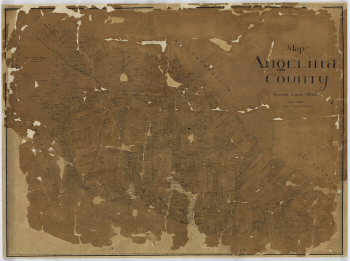
Map of Angelina County
Print $40.00
- Digital $50.00
Map of Angelina County
1899
Size 39.1 x 52.3 inches
Map/Doc 4777
Caldwell County Working Sketch 13

Print $20.00
- Digital $50.00
Caldwell County Working Sketch 13
1987
Size 40.3 x 34.3 inches
Map/Doc 67843
Hockley County Sketch File 4

Print $6.00
- Digital $50.00
Hockley County Sketch File 4
Size 9.1 x 11.2 inches
Map/Doc 26536
Henderson County Working Sketch 43

Print $20.00
- Digital $50.00
Henderson County Working Sketch 43
1994
Size 36.7 x 39.0 inches
Map/Doc 66176
[Surveys along the Brazos River]
![39, [Surveys along the Brazos River], General Map Collection](https://historictexasmaps.com/wmedia_w700/maps/39.tif.jpg)
Print $3.00
- Digital $50.00
[Surveys along the Brazos River]
1840
Size 9.5 x 10.9 inches
Map/Doc 39
Jackson County Working Sketch 5

Print $20.00
- Digital $50.00
Jackson County Working Sketch 5
1953
Size 26.2 x 26.0 inches
Map/Doc 66453
Right of Way and Track Map, The Missouri, Kansas and Texas Ry. of Texas operated by the Missouri, Kansas and Texas Ry. of Texas, Henrietta Division

Print $40.00
- Digital $50.00
Right of Way and Track Map, The Missouri, Kansas and Texas Ry. of Texas operated by the Missouri, Kansas and Texas Ry. of Texas, Henrietta Division
1918
Size 25.2 x 56.6 inches
Map/Doc 64067

Hardeman County Working Sketch 16

Print $20.00
- Digital $50.00
Hardeman County Working Sketch 16
1982
Size 35.7 x 45.1 inches
Map/Doc 63397