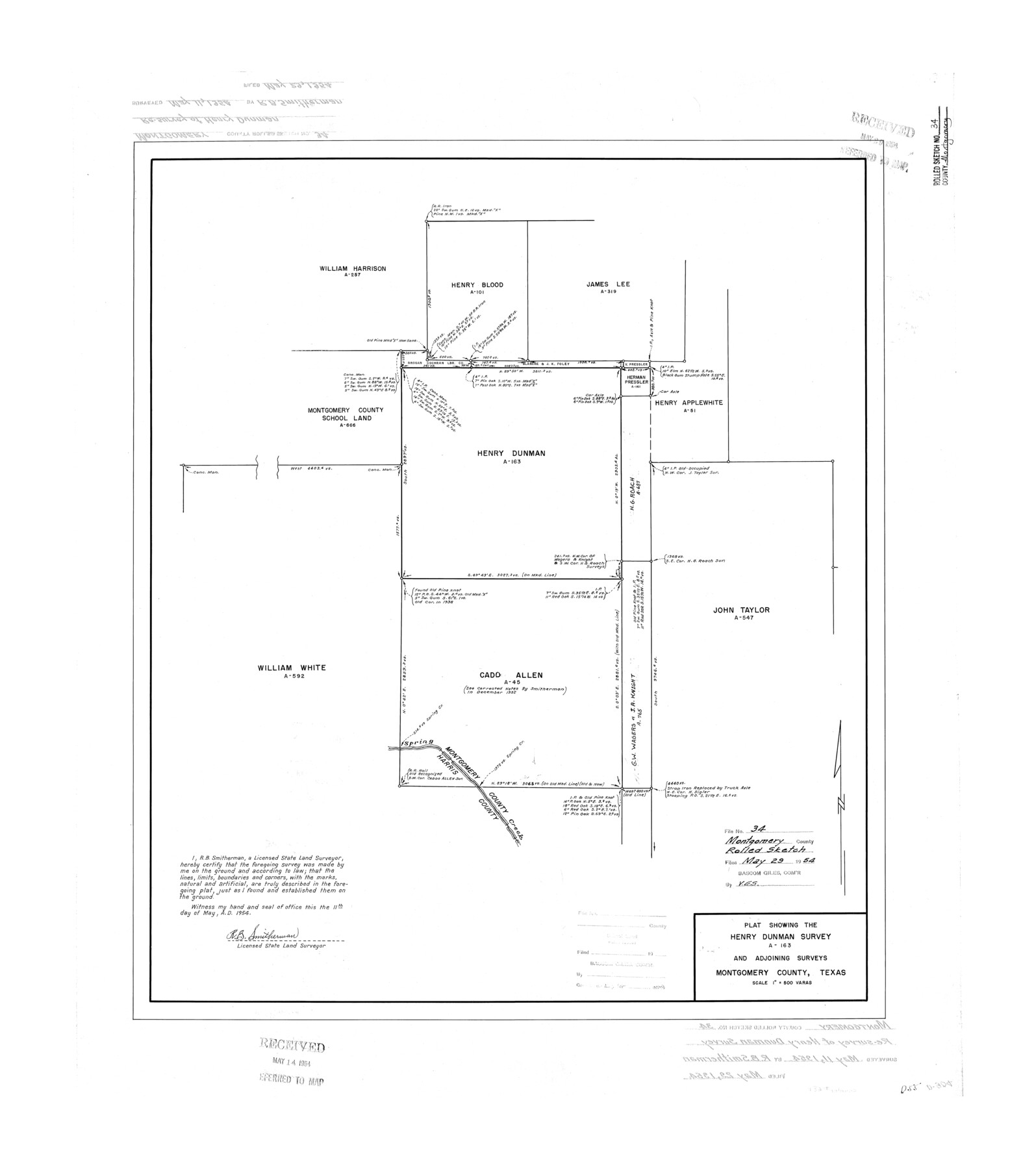
Montgomery County Rolled Sketch 34
Plat showing the Henry Dunman survey A-163 and adjoining surveys
-
Map/Doc
6811
-
Collection
General Map Collection
-
Object Dates
1954/5/11 (Creation Date)
1954/5/29 (File Date)
-
People and Organizations
R.B. Smitherman (Surveyor/Engineer)
-
Counties
Montgomery
-
Subjects
Surveying Rolled Sketch
-
Height x Width
32.1 x 28.4 inches
81.5 x 72.1 cm
-
Scale
1" = 500 varas
Part of: General Map Collection
Terrell County Rolled Sketch 14

Print $40.00
- Digital $50.00
Terrell County Rolled Sketch 14
Size 52.6 x 16.0 inches
Map/Doc 10309
Navarro County Sketch File 8

Print $4.00
- Digital $50.00
Navarro County Sketch File 8
1849
Size 13.2 x 8.5 inches
Map/Doc 32315
Cass County Working Sketch 13

Print $20.00
- Digital $50.00
Cass County Working Sketch 13
1945
Size 29.8 x 33.5 inches
Map/Doc 67916
Freestone County Working Sketch 3

Print $20.00
- Digital $50.00
Freestone County Working Sketch 3
1914
Size 18.8 x 16.2 inches
Map/Doc 69245
Milam County Working Sketch 16

Print $20.00
- Digital $50.00
Milam County Working Sketch 16
Size 30.4 x 36.2 inches
Map/Doc 71028
Angelina River, Mud Creek, Sheet 3

Print $4.00
- Digital $50.00
Angelina River, Mud Creek, Sheet 3
1937
Size 18.7 x 26.6 inches
Map/Doc 65077
Fort Bend County Working Sketch 7

Print $20.00
- Digital $50.00
Fort Bend County Working Sketch 7
1918
Size 20.6 x 30.7 inches
Map/Doc 69213
Hardin County Working Sketch 22

Print $20.00
- Digital $50.00
Hardin County Working Sketch 22
1948
Size 20.9 x 31.6 inches
Map/Doc 63420
Atascosa County Sketch File 2

Print $8.00
- Digital $50.00
Atascosa County Sketch File 2
1847
Size 7.8 x 5.9 inches
Map/Doc 13724
Nolan County Sketch File 10

Print $6.00
- Digital $50.00
Nolan County Sketch File 10
1902
Size 14.2 x 9.0 inches
Map/Doc 32484
San Saba County Sketch File 5

Print $4.00
- Digital $50.00
San Saba County Sketch File 5
Size 12.8 x 8.0 inches
Map/Doc 36412
Railroad Track Map, H&TCRRCo., Falls County, Texas

Print $4.00
- Digital $50.00
Railroad Track Map, H&TCRRCo., Falls County, Texas
1918
Size 11.6 x 18.3 inches
Map/Doc 62855
You may also like

Flight Mission No. DAG-24K, Frame 154, Matagorda County

Print $20.00
- Digital $50.00
Flight Mission No. DAG-24K, Frame 154, Matagorda County
1953
Size 18.5 x 22.2 inches
Map/Doc 86568
General Highway Map. Detail of Cities and Towns in Taylor County, Texas [Abilene and vicinity]
![79673, General Highway Map. Detail of Cities and Towns in Taylor County, Texas [Abilene and vicinity], Texas State Library and Archives](https://historictexasmaps.com/wmedia_w700/maps/79673.tif.jpg)
Print $20.00
General Highway Map. Detail of Cities and Towns in Taylor County, Texas [Abilene and vicinity]
1961
Size 18.2 x 24.8 inches
Map/Doc 79673
Working Sketch in Bastrop County

Print $20.00
- Digital $50.00
Working Sketch in Bastrop County
1923
Size 32.6 x 37.9 inches
Map/Doc 90147
Harris County Working Sketch 69

Print $20.00
- Digital $50.00
Harris County Working Sketch 69
1956
Size 32.7 x 28.2 inches
Map/Doc 65961
Shores of Nueces Bay, Texas

Print $40.00
- Digital $50.00
Shores of Nueces Bay, Texas
1882
Size 33.0 x 54.3 inches
Map/Doc 73464
[Blocks A, RG, O, B and 11]
![92861, [Blocks A, RG, O, B and 11], Twichell Survey Records](https://historictexasmaps.com/wmedia_w700/maps/92861-1.tif.jpg)
Print $20.00
- Digital $50.00
[Blocks A, RG, O, B and 11]
Size 21.0 x 18.1 inches
Map/Doc 92861
Milam County Working Sketch 8

Print $20.00
- Digital $50.00
Milam County Working Sketch 8
1970
Size 27.1 x 30.7 inches
Map/Doc 71023
Kenedy County Aerial Photograph Index Sheet 5

Print $20.00
- Digital $50.00
Kenedy County Aerial Photograph Index Sheet 5
1943
Size 23.5 x 19.6 inches
Map/Doc 89046
General Highway Map. Detail of Cities and Towns in Harris County, Texas

Print $20.00
General Highway Map. Detail of Cities and Towns in Harris County, Texas
1961
Size 18.2 x 24.6 inches
Map/Doc 79503
Pecos County Rolled Sketch 126

Print $20.00
- Digital $50.00
Pecos County Rolled Sketch 126
1948
Size 42.5 x 38.4 inches
Map/Doc 9724
2026 Save Texas History™ Map Calendar
.jpg)
Price $5.00
2026 Save Texas History™ Map Calendar
2025
Size 11.0 x 8.5 inches
Map/Doc 97491