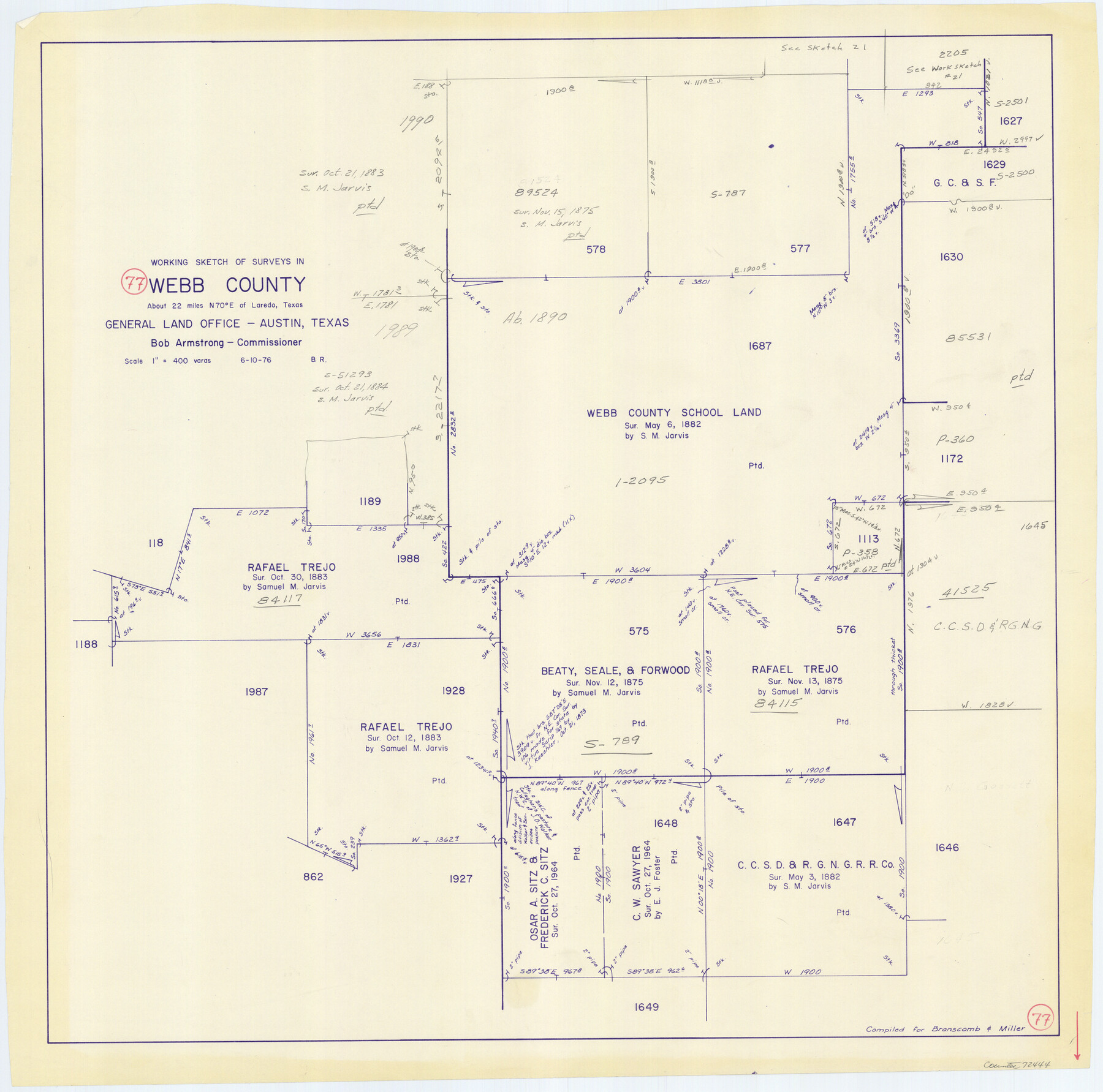
Webb County Working Sketch 77
-
Map/Doc
72444
-
Collection
General Map Collection
-
Object Dates
6/10/1976 (Creation Date)
-
People and Organizations
Beverly Robison (Draftsman)
-
Counties
Webb
-
Subjects
Surveying Working Sketch
-
Height x Width
25.8 x 26.1 inches
65.5 x 66.3 cm
-
Scale
1" = 400 varas
Part of: General Map Collection
Flight Mission No. CRK-3P, Frame 130, Refugio County

Print $20.00
- Digital $50.00
Flight Mission No. CRK-3P, Frame 130, Refugio County
1956
Size 18.6 x 22.3 inches
Map/Doc 86918
Bandera County Working Sketch 41

Print $20.00
- Digital $50.00
Bandera County Working Sketch 41
1977
Size 31.3 x 37.7 inches
Map/Doc 67637
Galveston County NRC Article 33.136 Sketch 11

Print $20.00
- Digital $50.00
Galveston County NRC Article 33.136 Sketch 11
2001
Size 22.5 x 33.9 inches
Map/Doc 61594
Flight Mission No. DQN-2K, Frame 138, Calhoun County

Print $20.00
- Digital $50.00
Flight Mission No. DQN-2K, Frame 138, Calhoun County
1953
Size 16.1 x 16.0 inches
Map/Doc 84307
Baylor County Sketch File A7

Print $6.00
- Digital $50.00
Baylor County Sketch File A7
1899
Size 9.1 x 14.6 inches
Map/Doc 14091
Real County Sketch File 7

Print $8.00
- Digital $50.00
Real County Sketch File 7
1931
Size 11.3 x 8.8 inches
Map/Doc 35055
Coryell County Sketch File 5

Print $40.00
- Digital $50.00
Coryell County Sketch File 5
1858
Size 16.0 x 12.7 inches
Map/Doc 19345
Denton County Working Sketch 24

Print $20.00
- Digital $50.00
Denton County Working Sketch 24
1989
Size 22.2 x 30.0 inches
Map/Doc 68629
Flight Mission No. DAG-28K, Frame 26, Matagorda County

Print $20.00
- Digital $50.00
Flight Mission No. DAG-28K, Frame 26, Matagorda County
1953
Size 18.5 x 22.3 inches
Map/Doc 86594
Brown County Sketch File 19

Print $8.00
- Digital $50.00
Brown County Sketch File 19
1873
Size 12.8 x 8.2 inches
Map/Doc 16616
Pecos County Rolled Sketch 174

Print $20.00
- Digital $50.00
Pecos County Rolled Sketch 174
Size 23.3 x 25.0 inches
Map/Doc 7294
Howard County Working Sketch 12

Print $20.00
- Digital $50.00
Howard County Working Sketch 12
1980
Size 39.2 x 37.0 inches
Map/Doc 66280
You may also like
[St. L. S.-W. Ry. of Texas, Map of Lufkin Branch in Smith County, Texas]
![64693, [St. L. S.-W. Ry. of Texas, Map of Lufkin Branch in Smith County, Texas], General Map Collection](https://historictexasmaps.com/wmedia_w700/maps/64693.tif.jpg)
Print $40.00
- Digital $50.00
[St. L. S.-W. Ry. of Texas, Map of Lufkin Branch in Smith County, Texas]
1912
Size 24.2 x 121.2 inches
Map/Doc 64693
Topographical Map of the Rio Grande, Sheet No. 1

Print $20.00
- Digital $50.00
Topographical Map of the Rio Grande, Sheet No. 1
1912
Map/Doc 89525
Neches River, Watershed of the Neches River

Print $6.00
- Digital $50.00
Neches River, Watershed of the Neches River
1925
Size 34.6 x 28.3 inches
Map/Doc 65085
Hamilton County Rolled Sketch 3

Print $20.00
- Digital $50.00
Hamilton County Rolled Sketch 3
1919
Size 20.6 x 26.2 inches
Map/Doc 6070
San Patricio County Rolled Sketch 31

Print $20.00
- Digital $50.00
San Patricio County Rolled Sketch 31
1941
Size 43.1 x 42.6 inches
Map/Doc 9898

Bell County Working Sketch 5

Print $20.00
- Digital $50.00
Bell County Working Sketch 5
1942
Size 26.9 x 21.0 inches
Map/Doc 67345

Flight Mission No. DQN-7K, Frame 39, Calhoun County

Print $20.00
- Digital $50.00
Flight Mission No. DQN-7K, Frame 39, Calhoun County
1953
Size 19.0 x 22.5 inches
Map/Doc 84477
Blanco County Sketch File 31a

Print $4.00
- Digital $50.00
Blanco County Sketch File 31a
1889
Size 8.6 x 14.1 inches
Map/Doc 14631
Hansford County Sketch File 2

Print $13.00
- Digital $50.00
Hansford County Sketch File 2
1901
Size 76.7 x 25.5 inches
Map/Doc 10476
[Surveys between the Sabine and Red Rivers made for titles under Radford Berry, Commissioner]
![14, [Surveys between the Sabine and Red Rivers made for titles under Radford Berry, Commissioner], General Map Collection](https://historictexasmaps.com/wmedia_w700/maps/14.tif.jpg)
Print $20.00
- Digital $50.00
[Surveys between the Sabine and Red Rivers made for titles under Radford Berry, Commissioner]
1835
Size 22.3 x 15.9 inches
Map/Doc 14