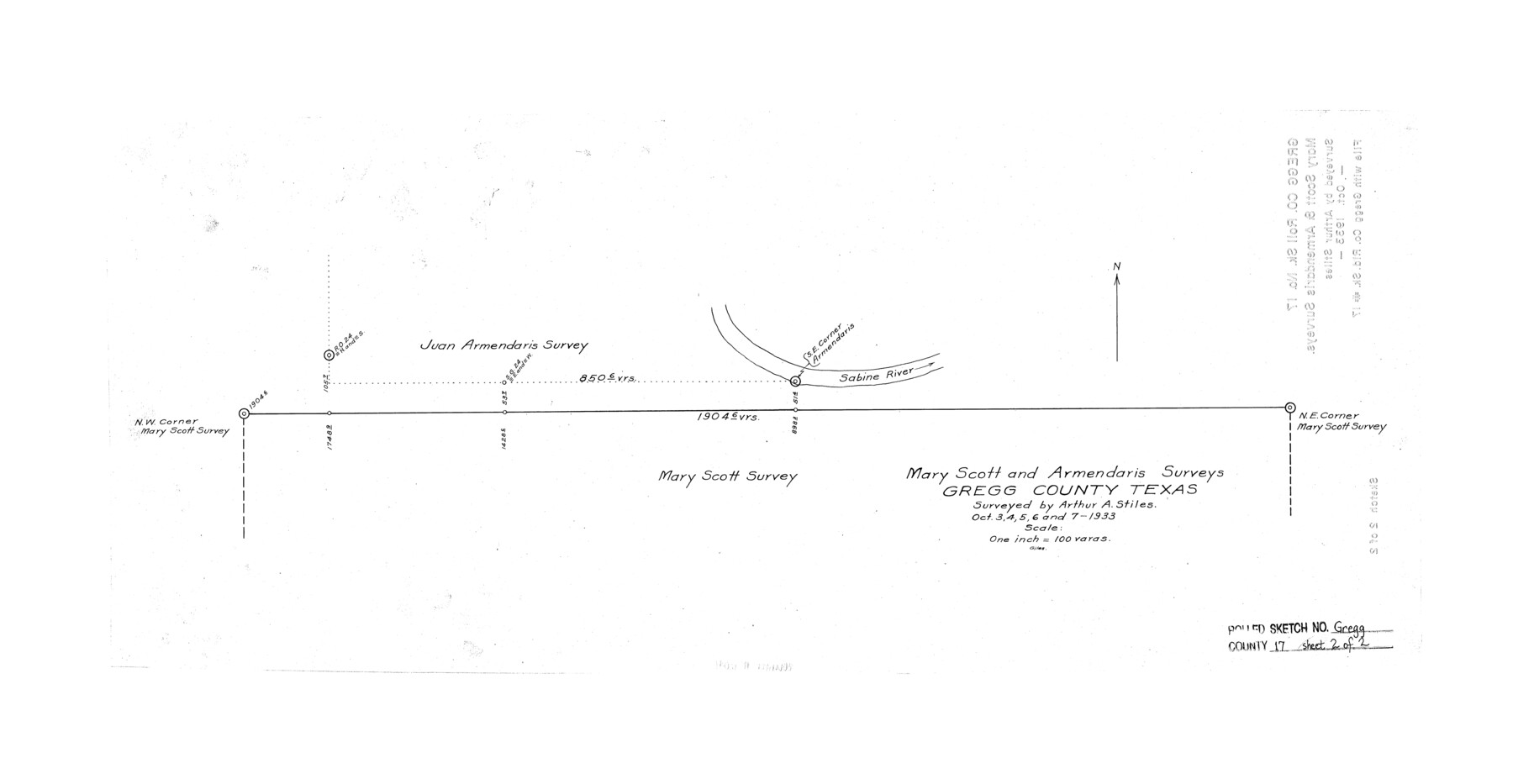
Gregg County Rolled Sketch 17
Mary Scott and Armendaris surveys - [Sheet 2 of 2]
-
Map/Doc
6041
-
Collection
General Map Collection
-
Object Dates
1933/10/7 (Creation Date)
-
People and Organizations
Arthur A. Stiles (Surveyor/Engineer)
-
Counties
Gregg
-
Subjects
Surveying Rolled Sketch
-
Height x Width
14.2 x 27.5 inches
36.1 x 69.9 cm
-
Scale
1" = 100 varas
Part of: General Map Collection
[Surveys in the Bexar District along Hondo and Seco Creeks]
![314, [Surveys in the Bexar District along Hondo and Seco Creeks], General Map Collection](https://historictexasmaps.com/wmedia_w700/maps/314.tif.jpg)
Print $3.00
- Digital $50.00
[Surveys in the Bexar District along Hondo and Seco Creeks]
1847
Size 9.3 x 9.9 inches
Map/Doc 314
Presidio County Sketch File 105

Print $20.00
- Digital $50.00
Presidio County Sketch File 105
Size 13.1 x 20.6 inches
Map/Doc 82962
Montgomery County Working Sketch 73

Print $20.00
- Digital $50.00
Montgomery County Working Sketch 73
1980
Size 19.5 x 42.9 inches
Map/Doc 71180
Palo Pinto County Working Sketch 4

Print $20.00
- Digital $50.00
Palo Pinto County Working Sketch 4
1913
Map/Doc 71387
Reeves County Rolled Sketch 19

Print $20.00
- Digital $50.00
Reeves County Rolled Sketch 19
1969
Size 23.8 x 21.5 inches
Map/Doc 7488
A Map of the Internal Provinces of New Spain

Print $20.00
- Digital $50.00
A Map of the Internal Provinces of New Spain
1810
Size 19.8 x 21.0 inches
Map/Doc 95156
Right of Way Map Fort Worth & Denver City Railroad through Hardeman County

Print $40.00
- Digital $50.00
Right of Way Map Fort Worth & Denver City Railroad through Hardeman County
1885
Size 23.8 x 121.2 inches
Map/Doc 64424
Controlled Mosaic by Jack Amman Photogrammetric Engineers, Inc - Sheet 10

Print $20.00
- Digital $50.00
Controlled Mosaic by Jack Amman Photogrammetric Engineers, Inc - Sheet 10
1954
Size 20.0 x 24.0 inches
Map/Doc 83454
La Salle County Rolled Sketch 30

Print $20.00
- Digital $50.00
La Salle County Rolled Sketch 30
Size 30.1 x 40.8 inches
Map/Doc 6590
Brewster County Sketch File N-1

Print $40.00
- Digital $50.00
Brewster County Sketch File N-1
Size 16.6 x 22.1 inches
Map/Doc 10961
Limestone County Sketch File 16

Print $4.00
- Digital $50.00
Limestone County Sketch File 16
Size 12.8 x 8.3 inches
Map/Doc 30185
Sterling County Rolled Sketch 10

Print $20.00
- Digital $50.00
Sterling County Rolled Sketch 10
1939
Size 24.2 x 31.2 inches
Map/Doc 7846
You may also like
Jefferson County NRC Article 33.136 Sketch 11

Print $46.00
- Digital $50.00
Jefferson County NRC Article 33.136 Sketch 11
2012
Size 24.0 x 36.0 inches
Map/Doc 95011
Webb County Sketch File 60

Print $8.00
- Digital $50.00
Webb County Sketch File 60
1943
Size 14.4 x 8.9 inches
Map/Doc 39855
El Paso County Working Sketch 28

Print $20.00
- Digital $50.00
El Paso County Working Sketch 28
1966
Size 24.0 x 31.5 inches
Map/Doc 69050
Index for Texas Railroad ROW & track maps available on microfilm at THD & Archives and Records

Print $2.00
- Digital $50.00
Index for Texas Railroad ROW & track maps available on microfilm at THD & Archives and Records
1977
Size 11.2 x 8.8 inches
Map/Doc 60757
Travis County Sketch File 44

Print $20.00
- Digital $50.00
Travis County Sketch File 44
1927
Size 21.6 x 19.3 inches
Map/Doc 12466
Upshur County Rolled Sketch 6

Print $20.00
- Digital $50.00
Upshur County Rolled Sketch 6
2003
Size 37.0 x 25.1 inches
Map/Doc 81941
General Highway Map, Leon County, Texas

Print $20.00
General Highway Map, Leon County, Texas
1940
Size 18.3 x 24.9 inches
Map/Doc 79172
Upton County Rolled Sketch 25

Print $20.00
- Digital $50.00
Upton County Rolled Sketch 25
1941
Size 33.2 x 34.5 inches
Map/Doc 10044

Coleman County Working Sketch 2
Print $20.00
- Digital $50.00
Coleman County Working Sketch 2
1917
Size 15.0 x 16.8 inches
Map/Doc 68068
[H. & T. C. Blocks 1 and 2]
![91049, [H. & T. C. Blocks 1 and 2], Twichell Survey Records](https://historictexasmaps.com/wmedia_w700/maps/91049-1.tif.jpg)
Print $3.00
- Digital $50.00
[H. & T. C. Blocks 1 and 2]
Size 13.3 x 11.7 inches
Map/Doc 91049
Carta Particular de la Parte sur del Seno Mexicano que comprehende las Cóstas de Yucatan y Sonda de Campeche, las de Tabasco, Veracruz y Tamaulipas

Carta Particular de la Parte sur del Seno Mexicano que comprehende las Cóstas de Yucatan y Sonda de Campeche, las de Tabasco, Veracruz y Tamaulipas
1825
Size 26.6 x 38.5 inches
Map/Doc 94567