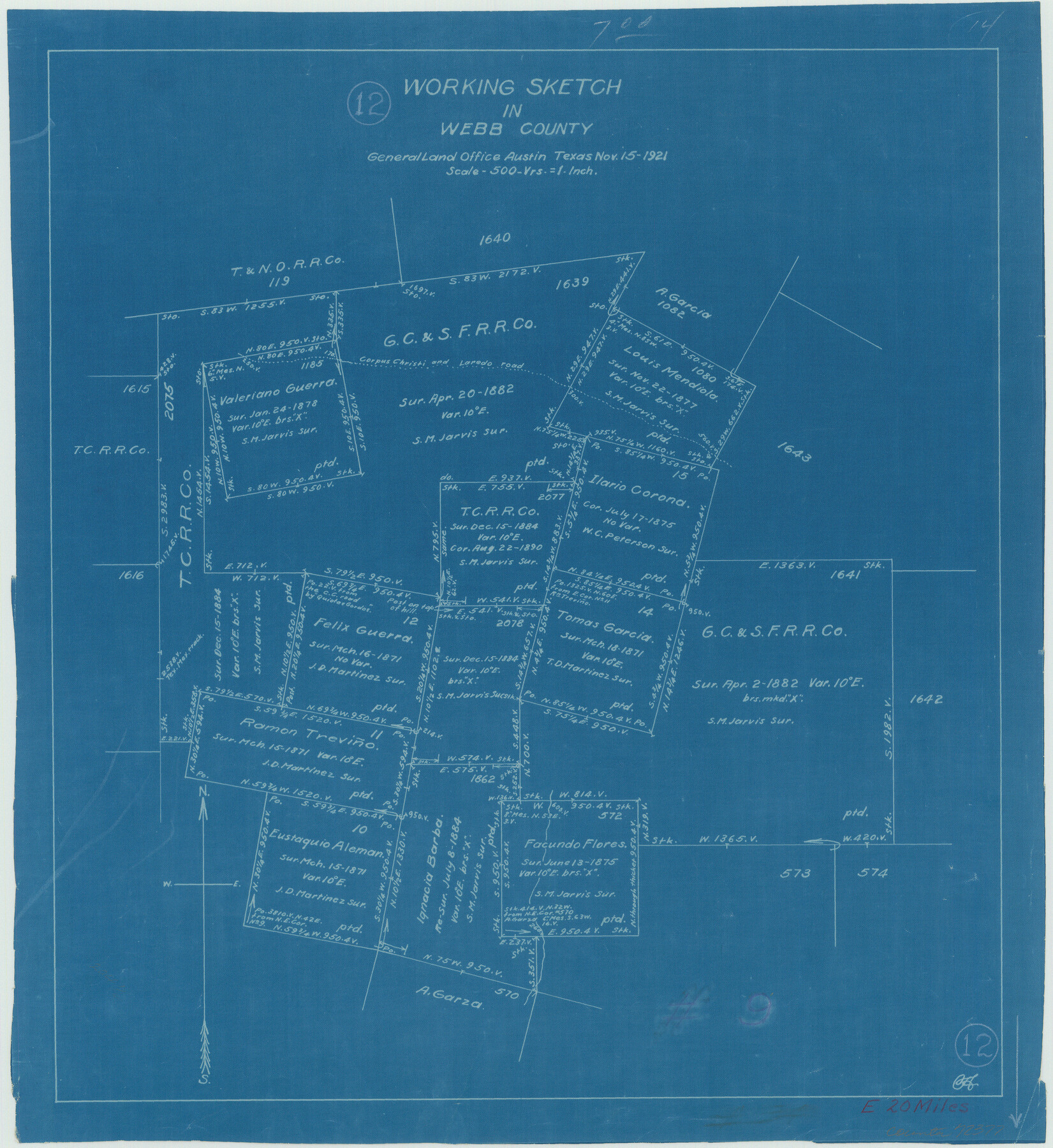
Webb County Working Sketch 12
- 
                          Map/Doc
72377
 - 
                            Collection
General Map Collection
 - 
                            Object Dates
11/15/1921 (Creation Date)
 - 
                            Counties
Webb
 - 
                            Subjects
Surveying Working Sketch
 - 
                            Height x Width
15.9 x 14.6 inches
40.4 x 37.1 cm
 - 
                            Scale
1" = 500 varas
 
Part of: General Map Collection
            Liberty County Working Sketch 56


                                            Print $40.00                    
                                             -                         Digital $50.00                                    
                Liberty County Working Sketch 56
1966
Size 52.0 x 28.4 inches
                                Map/Doc 70516
            
            Chambers County Sketch File 54


                                            Print $3.00                    
                                             -                         Digital $50.00                                    
                Chambers County Sketch File 54
1895
Size 16.5 x 10.3 inches
                                Map/Doc 18093
            
            Map of Martin County Texas


                                            Print $20.00                    
                                             -                         Digital $50.00                                    
                Map of Martin County Texas
1880
Size 22.6 x 19.0 inches
                                Map/Doc 4592
            
            Glasscock County Sketch File 17


                                            Print $44.00                    
                                             -                         Digital $50.00                                    
                Glasscock County Sketch File 17
1936
Size 11.4 x 8.8 inches
                                Map/Doc 24188
            
            Terrell County Rolled Sketch 41


                                            Print $20.00                    
                                             -                         Digital $50.00                                    
                Terrell County Rolled Sketch 41
Size 18.6 x 34.3 inches
                                Map/Doc 9990
            
            Dallas County Boundary File 8 and 8a


                                            Print $4.00                    
                                             -                         Digital $50.00                                    
                Dallas County Boundary File 8 and 8a
Size 11.2 x 8.7 inches
                                Map/Doc 52311
            
            Webb County Sketch File 51


                                            Print $4.00                    
                                             -                         Digital $50.00                                    
                Webb County Sketch File 51
1938
Size 11.3 x 8.8 inches
                                Map/Doc 39837
            
            Cameron County State Real Property Sketch 1


                                            Print $20.00                    
                                             -                         Digital $50.00                                    
                Cameron County State Real Property Sketch 1
1996
Size 25.1 x 38.9 inches
                                Map/Doc 80130
            
            Meanders of Sulphur Fork of Red River, Red River County, Texas


                                            Print $3.00                    
                                             -                         Digital $50.00                                    
                Meanders of Sulphur Fork of Red River, Red River County, Texas
1841
Size 9.9 x 15.8 inches
                                Map/Doc 65781
            
            McLennan County Sketch File 21


                                            Print $4.00                    
                                             -                         Digital $50.00                                    
                McLennan County Sketch File 21
Size 9.0 x 8.2 inches
                                Map/Doc 31294
            
            Map of Matagorda County


                                            Print $20.00                    
                                             -                         Digital $50.00                                    
                Map of Matagorda County
1865
Size 26.9 x 25.0 inches
                                Map/Doc 3842
            
            Runnels County


                                            Print $20.00                    
                                             -                         Digital $50.00                                    
                Runnels County
1898
Size 43.3 x 36.9 inches
                                Map/Doc 63009
            You may also like
            Scrivener's North-west Sub-division, Wichita County, Texas


                                            Print $20.00                    
                                             -                         Digital $50.00                                    
                Scrivener's North-west Sub-division, Wichita County, Texas
Size 20.0 x 26.0 inches
                                Map/Doc 91994
            
            Hudspeth County Sketch File 16a


                                            Print $2.00                    
                                             -                         Digital $50.00                                    
                Hudspeth County Sketch File 16a
1886
Size 8.7 x 5.8 inches
                                Map/Doc 26953
            
            Dallam County Sketch File 4


                                            Print $20.00                    
                                             -                         Digital $50.00                                    
                Dallam County Sketch File 4
Size 27.7 x 8.5 inches
                                Map/Doc 11279
            
            Bee County Working Sketch 23


                                            Print $20.00                    
                                             -                         Digital $50.00                                    
                Bee County Working Sketch 23
1985
Size 32.6 x 31.1 inches
                                Map/Doc 67273
            
            Hardin County Sketch File 1


                                            Print $8.00                    
                                             -                         Digital $50.00                                    
                Hardin County Sketch File 1
1851
Size 10.0 x 6.9 inches
                                Map/Doc 25079
            
            Flight Mission No. DAG-21K, Frame 96, Matagorda County


                                            Print $20.00                    
                                             -                         Digital $50.00                                    
                Flight Mission No. DAG-21K, Frame 96, Matagorda County
1952
Size 18.4 x 22.4 inches
                                Map/Doc 86425
            
            A Topographical Map of the Government Tract Adjoining the City of Austin


                                            Print $20.00                    
                                             -                         Digital $50.00                                    
                A Topographical Map of the Government Tract Adjoining the City of Austin
1840
Size 40.7 x 36.1 inches
                                Map/Doc 2177
            
            Randall County Rolled Sketch 3


                                            Print $20.00                    
                                             -                         Digital $50.00                                    
                Randall County Rolled Sketch 3
Size 22.0 x 24.9 inches
                                Map/Doc 7423
            
            Jeff Davis County Rolled Sketch 1


                                            Print $20.00                    
                                             -                         Digital $50.00                                    
                Jeff Davis County Rolled Sketch 1
1882
Size 23.0 x 43.2 inches
                                Map/Doc 6359
            
            [Missouri, Kansas & Texas Line Map through Bastrop County]


                                            Print $40.00                    
                                             -                         Digital $50.00                                    
                [Missouri, Kansas & Texas Line Map through Bastrop County]
1916
Size 26.2 x 121.8 inches
                                Map/Doc 64028
            
            [Area north of Leagues 1 & 4, Morris County School Land]


                                            Print $20.00                    
                                             -                         Digital $50.00                                    
                [Area north of Leagues 1 & 4, Morris County School Land]
Size 21.3 x 16.0 inches
                                Map/Doc 90353
            
            Nueces County NRC Article 33.136 Location Key Sheet


                                            Print $20.00                    
                                             -                         Digital $50.00                                    
                Nueces County NRC Article 33.136 Location Key Sheet
1975
Size 27.0 x 22.8 inches
                                Map/Doc 77033