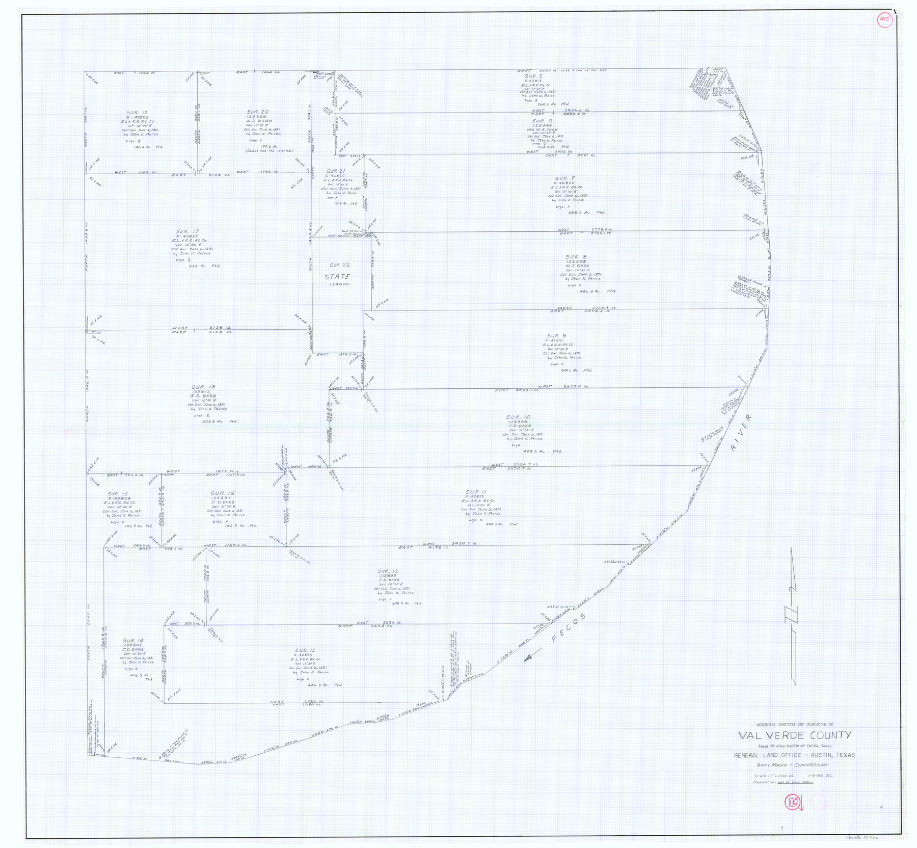
Val Verde County Working Sketch 105
-
Map/Doc
72240
-
Collection
General Map Collection
-
Object Dates
1/4/1983 (Creation Date)
-
People and Organizations
Elisandro Leos (Draftsman)
-
Counties
Val Verde
-
Subjects
Surveying Working Sketch
-
Height x Width
39.8 x 43.0 inches
101.1 x 109.2 cm
-
Scale
1" = 200 varas
Part of: General Map Collection
Johnson County Sketch File 4

Print $10.00
- Digital $50.00
Johnson County Sketch File 4
1858
Size 7.9 x 7.6 inches
Map/Doc 28435
Llano County Boundary File 1a

Print $44.00
- Digital $50.00
Llano County Boundary File 1a
Size 13.2 x 8.1 inches
Map/Doc 56430
Taylor County Sketch File 12

Print $4.00
- Digital $50.00
Taylor County Sketch File 12
Size 8.6 x 12.8 inches
Map/Doc 37796
Van Zandt County Sketch File 27a

Print $22.00
- Digital $50.00
Van Zandt County Sketch File 27a
1894
Size 17.4 x 14.5 inches
Map/Doc 39449
Starr County Working Sketch Graphic Index

Print $40.00
- Digital $50.00
Starr County Working Sketch Graphic Index
1977
Size 43.0 x 55.5 inches
Map/Doc 76701
Jasper County Working Sketch 14

Print $40.00
- Digital $50.00
Jasper County Working Sketch 14
1920
Size 37.9 x 55.1 inches
Map/Doc 66476
La Salle County Working Sketch Graphic Index

Print $40.00
- Digital $50.00
La Salle County Working Sketch Graphic Index
1923
Size 48.2 x 42.0 inches
Map/Doc 76615
Location of the Southern Kansas Railway of Texas, Gray County, Texas

Print $40.00
- Digital $50.00
Location of the Southern Kansas Railway of Texas, Gray County, Texas
1887
Size 19.9 x 75.3 inches
Map/Doc 64036
Map of subdivision of submerged land in the Gulf of Mexico fronting on Matagorda Island and Peninsula

Print $40.00
- Digital $50.00
Map of subdivision of submerged land in the Gulf of Mexico fronting on Matagorda Island and Peninsula
1940
Size 28.2 x 61.3 inches
Map/Doc 2929
Reagan County Sketch File 6

Print $20.00
- Digital $50.00
Reagan County Sketch File 6
1927
Size 23.4 x 14.1 inches
Map/Doc 12215
Lipscomb County Working Sketch 5

Print $20.00
- Digital $50.00
Lipscomb County Working Sketch 5
1977
Size 26.8 x 30.0 inches
Map/Doc 70581
Roberts County Working Sketch 12

Print $20.00
- Digital $50.00
Roberts County Working Sketch 12
Size 25.5 x 22.5 inches
Map/Doc 63538
You may also like
Maps of Gulf Intracoastal Waterway, Texas - Sabine River to the Rio Grande and connecting waterways including ship channels

Print $20.00
- Digital $50.00
Maps of Gulf Intracoastal Waterway, Texas - Sabine River to the Rio Grande and connecting waterways including ship channels
1966
Size 14.6 x 22.3 inches
Map/Doc 61959
Knox County Working Sketch 13

Print $3.00
- Digital $50.00
Knox County Working Sketch 13
1953
Size 9.6 x 11.0 inches
Map/Doc 70255
Williamson County

Print $20.00
- Digital $50.00
Williamson County
1919
Size 22.5 x 29.8 inches
Map/Doc 4643
Trinity County Sketch File 11

Print $8.00
- Digital $50.00
Trinity County Sketch File 11
1859
Size 6.2 x 6.2 inches
Map/Doc 38531
Nueces County Rolled Sketch 113B

Print $20.00
- Digital $50.00
Nueces County Rolled Sketch 113B
1972
Size 18.6 x 24.2 inches
Map/Doc 7123
Pecos County Sketch File 38

Print $4.00
- Digital $50.00
Pecos County Sketch File 38
1895
Size 11.3 x 8.8 inches
Map/Doc 33720
Gray County, Texas

Print $20.00
- Digital $50.00
Gray County, Texas
Size 13.4 x 14.9 inches
Map/Doc 90722
Crockett County Working Sketch Graphic Index - northeast part

Print $20.00
- Digital $50.00
Crockett County Working Sketch Graphic Index - northeast part
1976
Size 35.6 x 46.4 inches
Map/Doc 76511
Phelps & Ensign's Travellers' Guide, and Map of the United States containing the roads, distances, steam boat and canal routes & c.

Print $20.00
- Digital $50.00
Phelps & Ensign's Travellers' Guide, and Map of the United States containing the roads, distances, steam boat and canal routes & c.
1841
Size 28.8 x 33.9 inches
Map/Doc 96875
Polk County Sketch File 23

Print $20.00
- Digital $50.00
Polk County Sketch File 23
Size 18.0 x 18.6 inches
Map/Doc 12191
Cottle County Sketch File A1

Print $34.00
- Digital $50.00
Cottle County Sketch File A1
1882
Size 15.7 x 29.1 inches
Map/Doc 11199