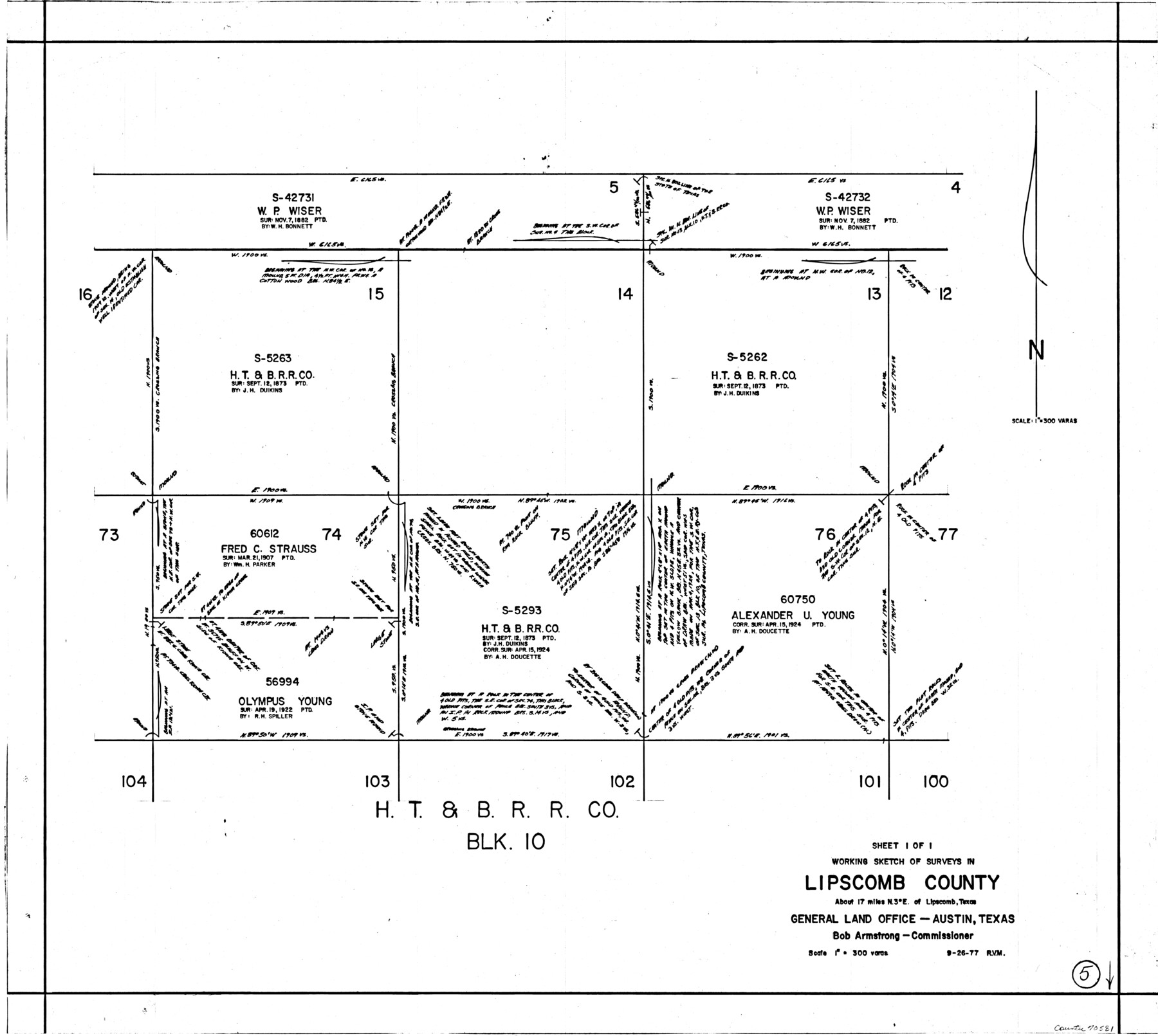
Lipscomb County Working Sketch 5
-
Map/Doc
70581
-
Collection
General Map Collection
-
Object Dates
9/26/1977 (Creation Date)
-
People and Organizations
Rosendo V. Molina (Draftsman)
-
Counties
Lipscomb
-
Subjects
Surveying Working Sketch
-
Height x Width
26.8 x 30.0 inches
68.1 x 76.2 cm
-
Scale
1" = 300 varas
Part of: General Map Collection

Map of Zavalla County

Print $20.00
- Digital $50.00
Map of Zavalla County
1862
Size 24.2 x 20.5 inches
Map/Doc 4180
Flight Mission No. CRC-5R, Frame 17, Chambers County

Print $20.00
- Digital $50.00
Flight Mission No. CRC-5R, Frame 17, Chambers County
1956
Size 18.8 x 22.5 inches
Map/Doc 84939
San Patricio County Sketch File 10

Print $8.00
San Patricio County Sketch File 10
1847
Size 13.3 x 8.4 inches
Map/Doc 36040
McLennan County Sketch File 14

Print $4.00
- Digital $50.00
McLennan County Sketch File 14
1872
Size 12.4 x 7.9 inches
Map/Doc 31272
Llano County Working Sketch Graphic Index

Print $20.00
- Digital $50.00
Llano County Working Sketch Graphic Index
1943
Size 43.7 x 42.6 inches
Map/Doc 76624
Freestone County Sketch File 12

Print $6.00
- Digital $50.00
Freestone County Sketch File 12
Size 8.2 x 6.3 inches
Map/Doc 23060
Reagan County

Print $40.00
- Digital $50.00
Reagan County
1915
Size 48.8 x 36.0 inches
Map/Doc 78429
Coke County Sketch File 17-18

Print $24.00
- Digital $50.00
Coke County Sketch File 17-18
1902
Size 16.6 x 14.2 inches
Map/Doc 11109

Starr County Sketch File 5

Print $40.00
- Digital $50.00
Starr County Sketch File 5
Size 31.4 x 40.7 inches
Map/Doc 82571
Glasscock County Working Sketch 8

Print $40.00
- Digital $50.00
Glasscock County Working Sketch 8
1955
Size 43.5 x 120.3 inches
Map/Doc 63181
You may also like
Map of a part of Laguna Madre showing subdivision for mineral development

Print $20.00
- Digital $50.00
Map of a part of Laguna Madre showing subdivision for mineral development
1948
Size 37.4 x 27.7 inches
Map/Doc 2914

Newton County Sketch File 42

Print $39.00
- Digital $50.00
Newton County Sketch File 42
1936
Size 13.2 x 8.7 inches
Map/Doc 32425
Presidio County Sketch File 81

Print $20.00
- Digital $50.00
Presidio County Sketch File 81
1949
Size 47.2 x 21.6 inches
Map/Doc 10579
El Paso County Working Sketch 45

Print $20.00
- Digital $50.00
El Paso County Working Sketch 45
1986
Size 38.0 x 27.0 inches
Map/Doc 69067
Trinity County Working Sketch 2

Print $20.00
- Digital $50.00
Trinity County Working Sketch 2
1905
Size 16.7 x 13.6 inches
Map/Doc 69450
Upton County Working Sketch 8

Print $20.00
- Digital $50.00
Upton County Working Sketch 8
1916
Size 21.9 x 16.8 inches
Map/Doc 69504
Orange County Sketch File 9b

Print $22.00
- Digital $50.00
Orange County Sketch File 9b
1873
Size 14.6 x 12.6 inches
Map/Doc 33315
Cottle County Rolled Sketch B

Print $20.00
- Digital $50.00
Cottle County Rolled Sketch B
1903
Size 32.5 x 43.4 inches
Map/Doc 8671
Jeff Davis County Rolled Sketch 38

Print $20.00
- Digital $50.00
Jeff Davis County Rolled Sketch 38
1994
Size 26.1 x 35.1 inches
Map/Doc 6381
A Plat of the League of land surveyed on the south-west side of the Rio San Bernardo between it and the Bay-Prairie

Print $20.00
- Digital $50.00
A Plat of the League of land surveyed on the south-west side of the Rio San Bernardo between it and the Bay-Prairie
1831
Size 37.3 x 24.0 inches
Map/Doc 13
![91464, [Block B7], Twichell Survey Records](https://historictexasmaps.com/wmedia_w700/maps/91464-1.tif.jpg)