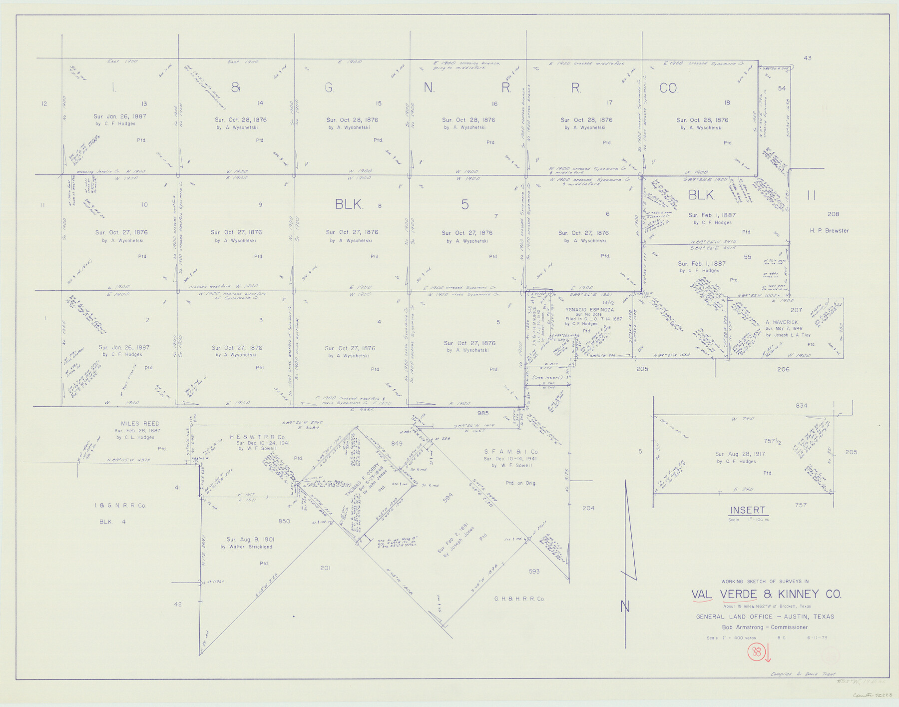
Val Verde County Working Sketch 88
-
Map/Doc
72223
-
Collection
General Map Collection
-
Object Dates
6/11/1973 (Creation Date)
-
People and Organizations
Beverly Christian (Draftsman)
-
Counties
Val Verde Kinney
-
Subjects
Surveying Working Sketch
-
Height x Width
29.0 x 36.9 inches
73.7 x 93.7 cm
-
Scale
1" = 400 varas
Part of: General Map Collection
Mills County Working Sketch 8

Print $20.00
- Digital $50.00
Mills County Working Sketch 8
1919
Size 27.6 x 23.3 inches
Map/Doc 71038
Township No. 5 South Range No. 12 West of the Indian Meridian

Print $4.00
- Digital $50.00
Township No. 5 South Range No. 12 West of the Indian Meridian
1875
Size 18.1 x 22.6 inches
Map/Doc 75159
Montgomery County Working Sketch 65

Print $20.00
- Digital $50.00
Montgomery County Working Sketch 65
1965
Size 21.5 x 16.7 inches
Map/Doc 71172
Hardeman County Sketch File 14

Print $8.00
- Digital $50.00
Hardeman County Sketch File 14
1884
Size 12.7 x 8.1 inches
Map/Doc 25022
Dallas County Working Sketch 7

Print $20.00
- Digital $50.00
Dallas County Working Sketch 7
1952
Size 17.3 x 23.5 inches
Map/Doc 68573
Culberson County Sketch File EM and RJ

Print $24.00
- Digital $50.00
Culberson County Sketch File EM and RJ
Size 13.3 x 8.8 inches
Map/Doc 20157
Morris County Rolled Sketch 2A

Print $20.00
- Digital $50.00
Morris County Rolled Sketch 2A
Size 24.0 x 18.8 inches
Map/Doc 10252
Orange County Working Sketch 38

Print $20.00
- Digital $50.00
Orange County Working Sketch 38
1964
Size 25.4 x 27.7 inches
Map/Doc 71370
Map of Ferguson State Farm, Madison County, Texas

Print $20.00
- Digital $50.00
Map of Ferguson State Farm, Madison County, Texas
Size 21.6 x 26.1 inches
Map/Doc 62989

San Jacinto County Working Sketch 1

Print $20.00
- Digital $50.00
San Jacinto County Working Sketch 1
Size 30.0 x 29.6 inches
Map/Doc 63714
Austin County Working Sketch 6

Print $20.00
- Digital $50.00
Austin County Working Sketch 6
1985
Size 30.3 x 28.5 inches
Map/Doc 67247
You may also like
McMullen County Working Sketch 56

Print $20.00
- Digital $50.00
McMullen County Working Sketch 56
1983
Size 23.9 x 24.1 inches
Map/Doc 70757
Presidio County Working Sketch 20

Print $20.00
- Digital $50.00
Presidio County Working Sketch 20
1943
Size 25.6 x 25.5 inches
Map/Doc 71696
Limestone Co.

Print $40.00
- Digital $50.00
Limestone Co.
1971
Size 48.3 x 33.4 inches
Map/Doc 73221
Trinity County Working Sketch 17

Print $20.00
- Digital $50.00
Trinity County Working Sketch 17
1978
Size 24.0 x 26.6 inches
Map/Doc 69466
Nueces County Rolled Sketch 27A

Print $40.00
- Digital $50.00
Nueces County Rolled Sketch 27A
1946
Size 11.6 x 52.4 inches
Map/Doc 76042
Mills County Sketch File A

Print $4.00
- Digital $50.00
Mills County Sketch File A
1890
Size 8.9 x 11.0 inches
Map/Doc 31646
Terry County Boundary File 4

Print $64.00
- Digital $50.00
Terry County Boundary File 4
Size 14.5 x 8.9 inches
Map/Doc 59236
Flight Mission No. DCL-5C, Frame 25, Kenedy County

Print $20.00
- Digital $50.00
Flight Mission No. DCL-5C, Frame 25, Kenedy County
1943
Size 18.4 x 22.3 inches
Map/Doc 85837
Right-of-Way and Track Map, Texas State Railroad operated by the T. and N. O. R.R. Co.

Print $40.00
- Digital $50.00
Right-of-Way and Track Map, Texas State Railroad operated by the T. and N. O. R.R. Co.
1917
Size 24.4 x 55.8 inches
Map/Doc 64174
Rockwall County Working Sketch 4

Print $20.00
- Digital $50.00
Rockwall County Working Sketch 4
1966
Size 34.9 x 28.9 inches
Map/Doc 63596
Crane County Sketch File 4

Print $6.00
- Digital $50.00
Crane County Sketch File 4
Size 13.6 x 10.9 inches
Map/Doc 19562
Railroad map of the state of Texas / compiled and engraved expressly for the American railroad manual.

Print $20.00
Railroad map of the state of Texas / compiled and engraved expressly for the American railroad manual.
1873
Size 13.4 x 9.5 inches
Map/Doc 93599