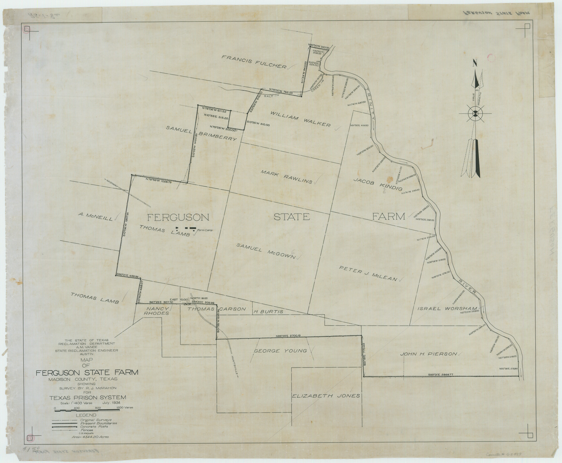
Map of Ferguson State Farm, Madison County, Texas
RG-1-8a
-
Map/Doc
62989
-
Collection
General Map Collection
-
People and Organizations
A.M. Vance (Author)
-
Counties
Madison
-
Height x Width
21.6 x 26.1 inches
54.9 x 66.3 cm
Part of: General Map Collection
[Right of Way & Track Map, The Texas & Pacific Ry. Co. Main Line]
![64686, [Right of Way & Track Map, The Texas & Pacific Ry. Co. Main Line], General Map Collection](https://historictexasmaps.com/wmedia_w700/maps/64686.tif.jpg)
Print $20.00
- Digital $50.00
[Right of Way & Track Map, The Texas & Pacific Ry. Co. Main Line]
Size 11.0 x 19.0 inches
Map/Doc 64686
Map of Collingsworth County

Print $20.00
- Digital $50.00
Map of Collingsworth County
1899
Size 42.8 x 38.5 inches
Map/Doc 4739
Upton County Sketch File 14a

Print $18.00
- Digital $50.00
Upton County Sketch File 14a
1927
Size 14.5 x 9.1 inches
Map/Doc 38864
Travis County Sketch File 62

Print $20.00
- Digital $50.00
Travis County Sketch File 62
1929
Size 20.6 x 18.2 inches
Map/Doc 12473
Reeves County Rolled Sketch N

Print $40.00
- Digital $50.00
Reeves County Rolled Sketch N
Size 44.5 x 74.7 inches
Map/Doc 9846
Jefferson County Working Sketch 41

Print $20.00
- Digital $50.00
Jefferson County Working Sketch 41
1985
Size 26.4 x 20.8 inches
Map/Doc 66585
Flight Mission No. CUG-1P, Frame 55, Kleberg County

Print $20.00
- Digital $50.00
Flight Mission No. CUG-1P, Frame 55, Kleberg County
1956
Size 18.5 x 22.3 inches
Map/Doc 86133
Edwards County Sketch File 43

Print $20.00
- Digital $50.00
Edwards County Sketch File 43
1947
Size 17.4 x 18.2 inches
Map/Doc 11441
Anderson County Sketch File 26

Print $40.00
- Digital $50.00
Anderson County Sketch File 26
1954
Size 22.7 x 17.4 inches
Map/Doc 10805
Karnes County Boundary File 2

Print $12.00
- Digital $50.00
Karnes County Boundary File 2
Size 14.1 x 8.7 inches
Map/Doc 55686
Angelina County Sketch File 11a

Print $4.00
- Digital $50.00
Angelina County Sketch File 11a
1860
Size 14.4 x 8.3 inches
Map/Doc 12942
East Part of Brewster Co.

Print $40.00
- Digital $50.00
East Part of Brewster Co.
1952
Size 48.8 x 31.9 inches
Map/Doc 1785
You may also like
Flight Mission No. DIX-10P, Frame 165, Aransas County

Print $20.00
- Digital $50.00
Flight Mission No. DIX-10P, Frame 165, Aransas County
1956
Size 18.6 x 22.3 inches
Map/Doc 83955
Nueces County NRC Article 33.136 Location Key Sheet

Print $20.00
- Digital $50.00
Nueces County NRC Article 33.136 Location Key Sheet
1975
Size 27.5 x 23.0 inches
Map/Doc 88589
Galveston County Sketch File 9

Print $6.00
- Digital $50.00
Galveston County Sketch File 9
1866
Size 10.1 x 8.1 inches
Map/Doc 23369
Hockley County Sketch File 15

Print $6.00
- Digital $50.00
Hockley County Sketch File 15
1912
Size 11.4 x 8.9 inches
Map/Doc 26550
Kinney County

Print $40.00
- Digital $50.00
Kinney County
1909
Size 48.4 x 42.7 inches
Map/Doc 16868
Brazoria County Working Sketch 32

Print $20.00
- Digital $50.00
Brazoria County Working Sketch 32
1979
Size 15.8 x 36.9 inches
Map/Doc 67517
Sketch of coast of Texas, Laguna Madre from Pt. of Rocks to Corpus Christi [and accompanying letter]
![72963, Sketch of coast of Texas, Laguna Madre from Pt. of Rocks to Corpus Christi [and accompanying letter], General Map Collection](https://historictexasmaps.com/wmedia_w700/maps/72963.tif.jpg)
Print $2.00
- Digital $50.00
Sketch of coast of Texas, Laguna Madre from Pt. of Rocks to Corpus Christi [and accompanying letter]
1882
Size 11.2 x 8.8 inches
Map/Doc 72963
Floyd County Sketch File 9

Print $20.00
- Digital $50.00
Floyd County Sketch File 9
1901
Size 22.1 x 15.3 inches
Map/Doc 11484
Outer Continental Shelf Leasing Maps (Texas Offshore Operations)

Print $20.00
- Digital $50.00
Outer Continental Shelf Leasing Maps (Texas Offshore Operations)
Size 17.7 x 14.1 inches
Map/Doc 75855
Wise County Rolled Sketch 5

Print $20.00
- Digital $50.00
Wise County Rolled Sketch 5
Size 19.4 x 21.4 inches
Map/Doc 8271
Nueces County Rolled Sketch 27

Print $40.00
- Digital $50.00
Nueces County Rolled Sketch 27
1946
Size 180.8 x 12.6 inches
Map/Doc 9596
