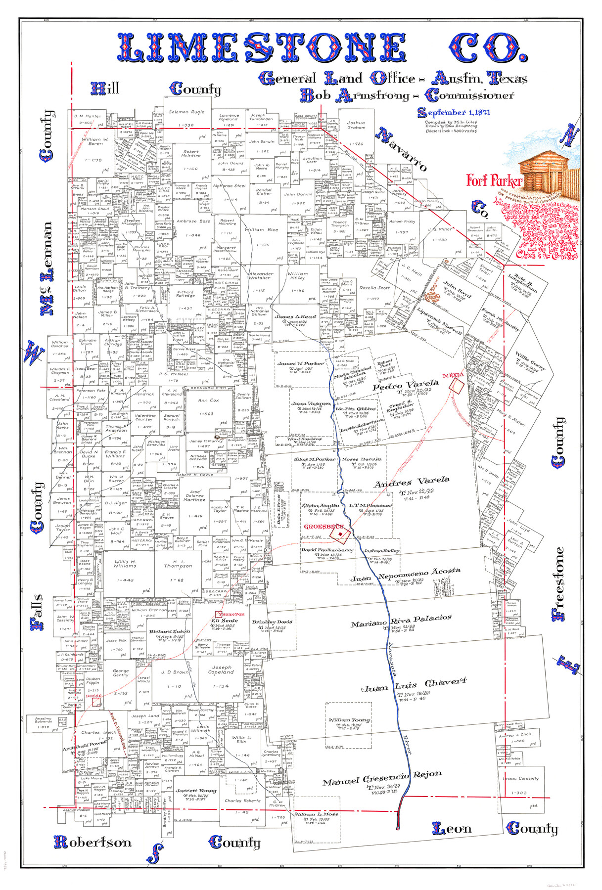
Limestone Co.
-
Map/Doc
73221
-
Collection
General Map Collection
-
Object Dates
1971/9/1 (Creation Date)
-
People and Organizations
Texas General Land Office (Publisher)
Eltea Armstrong (Draftsman)
Bob Armstrong (GLO Commissioner)
M. L. Liles (Compiler)
-
Counties
Limestone
-
Subjects
County
-
Height x Width
48.3 x 33.4 inches
122.7 x 84.8 cm
-
Comments
Hand lettered.
-
Features
SLS
Pin Oak Creek
Elm Branch [of Pin Oak Creek]
Tehuacana Hills
SPRR
Mexia
FW&D
Horn Hill
Groesbeck
Thornton
Navasota River
Road to Parker's Fort
Kosse
Steele Creek
Christmas Creek
Part of: General Map Collection
Val Verde County Sketch File XXX6

Print $6.00
- Digital $50.00
Val Verde County Sketch File XXX6
Size 17.0 x 9.9 inches
Map/Doc 39102
Photostat of section of hydrographic surveys H-5399, H-4822, H-470

Print $2.00
- Digital $50.00
Photostat of section of hydrographic surveys H-5399, H-4822, H-470
1933
Size 10.6 x 8.1 inches
Map/Doc 61159
Kimble County Working Sketch 31

Print $20.00
- Digital $50.00
Kimble County Working Sketch 31
1944
Size 34.8 x 34.6 inches
Map/Doc 70099

Galveston County NRC Article 33.136 Sketch 69

Print $76.00
- Digital $50.00
Galveston County NRC Article 33.136 Sketch 69
2012
Size 24.0 x 36.0 inches
Map/Doc 94669
Culberson County Working Sketch 31

Print $20.00
- Digital $50.00
Culberson County Working Sketch 31
1958
Size 30.5 x 30.0 inches
Map/Doc 68484
Van Zandt County Working Sketch Graphic Index

Print $20.00
- Digital $50.00
Van Zandt County Working Sketch Graphic Index
1972
Size 46.2 x 40.7 inches
Map/Doc 76727
Tarrant County

Print $20.00
- Digital $50.00
Tarrant County
1883
Size 35.5 x 32.8 inches
Map/Doc 4676
San Saba County Working Sketch 2

Print $20.00
- Digital $50.00
San Saba County Working Sketch 2
1928
Size 23.2 x 27.2 inches
Map/Doc 63790
Uvalde County Rolled Sketch 11

Print $20.00
- Digital $50.00
Uvalde County Rolled Sketch 11
1966
Size 28.1 x 27.8 inches
Map/Doc 8096
Duval County Boundary File 1

Print $26.00
- Digital $50.00
Duval County Boundary File 1
Size 8.4 x 3.7 inches
Map/Doc 52657
Presidio County Sketch File R

Print $18.00
- Digital $50.00
Presidio County Sketch File R
Size 10.3 x 8.4 inches
Map/Doc 34590
You may also like
Tourist Map of San Antonio showing points of interest, places of amusements, main thoroughfares and highways in and out of city and where they go

Print $20.00
- Digital $50.00
Tourist Map of San Antonio showing points of interest, places of amusements, main thoroughfares and highways in and out of city and where they go
Size 22.2 x 15.3 inches
Map/Doc 95956
Lee County Sketch File 1

Print $4.00
- Digital $50.00
Lee County Sketch File 1
1856
Size 13.1 x 8.2 inches
Map/Doc 29678
Louisiana and Texas Intracoastal Waterway

Print $20.00
- Digital $50.00
Louisiana and Texas Intracoastal Waterway
1929
Size 13.6 x 19.6 inches
Map/Doc 83342
Montgomery County Rolled Sketch 16

Print $20.00
- Digital $50.00
Montgomery County Rolled Sketch 16
Size 28.5 x 26.6 inches
Map/Doc 6804
[Blocks 36 and 37, Townships 1S-5S]
![93213, [Blocks 36 and 37, Townships 1S-5S], Twichell Survey Records](https://historictexasmaps.com/wmedia_w700/maps/93213-1.tif.jpg)
Print $40.00
- Digital $50.00
[Blocks 36 and 37, Townships 1S-5S]
Size 28.9 x 83.7 inches
Map/Doc 93213
Map of Wilson County

Print $20.00
- Digital $50.00
Map of Wilson County
1840
Size 24.4 x 21.0 inches
Map/Doc 4154
Briscoe County Sketch File 11

Print $9.00
- Digital $50.00
Briscoe County Sketch File 11
Size 11.8 x 11.0 inches
Map/Doc 16422
Hutchinson County Rolled Sketch 40

Print $20.00
- Digital $50.00
Hutchinson County Rolled Sketch 40
1981
Size 26.8 x 37.4 inches
Map/Doc 6303
Wichita County Boundary File 4

Print $20.00
- Digital $50.00
Wichita County Boundary File 4
Size 12.4 x 38.3 inches
Map/Doc 59914
Pecos County Working Sketch 18

Print $20.00
- Digital $50.00
Pecos County Working Sketch 18
1917
Size 18.4 x 20.9 inches
Map/Doc 71488
[I. & G. N. RR. Co. Blk. 6, Blks M8, M9 and M10]
![90267, [I. & G. N. RR. Co. Blk. 6, Blks M8, M9 and M10], Twichell Survey Records](https://historictexasmaps.com/wmedia_w700/maps/90267-1.tif.jpg)
Print $20.00
- Digital $50.00
[I. & G. N. RR. Co. Blk. 6, Blks M8, M9 and M10]
Size 34.2 x 20.3 inches
Map/Doc 90267
Eastland County Working Sketch 8

Print $20.00
- Digital $50.00
Eastland County Working Sketch 8
1919
Size 13.5 x 11.1 inches
Map/Doc 68789