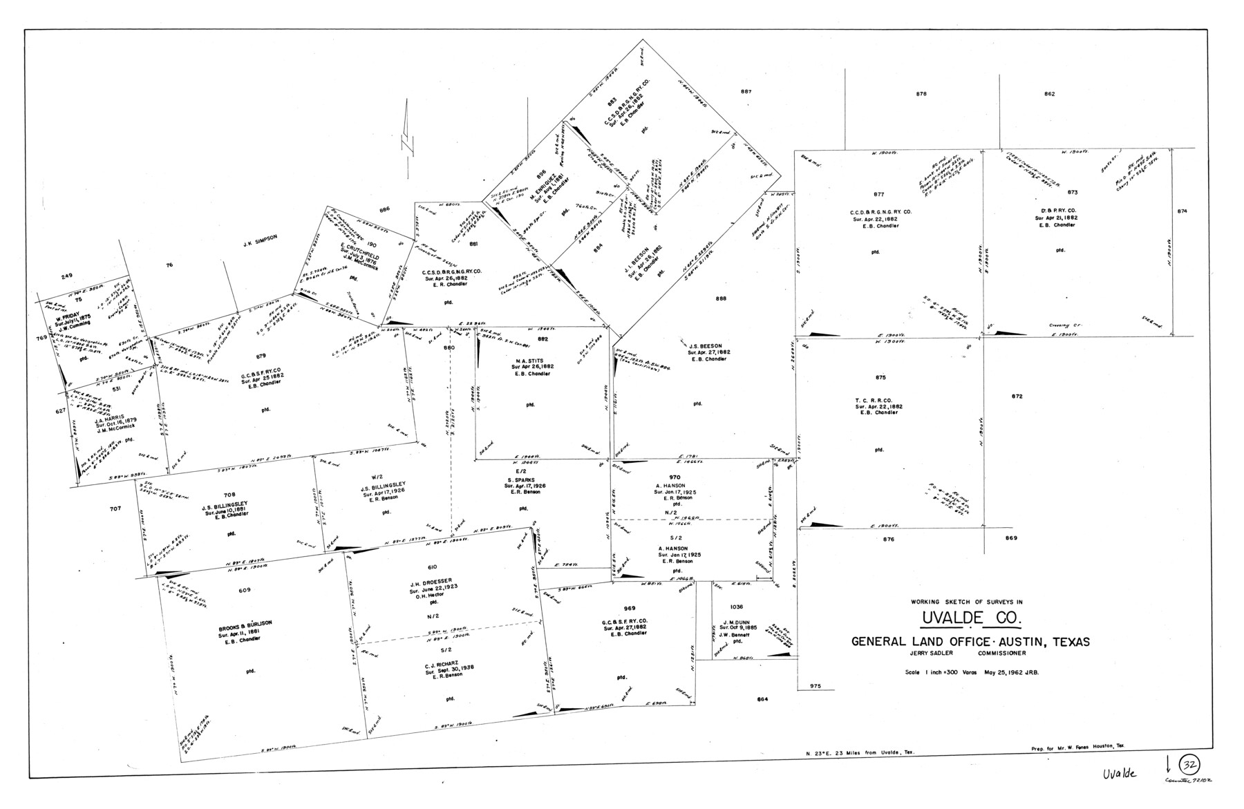
Uvalde County Working Sketch 32
-
Map/Doc
72102
-
Collection
General Map Collection
-
Object Dates
5/25/1962 (Creation Date)
-
Counties
Uvalde
-
Subjects
Surveying Working Sketch
-
Height x Width
27.2 x 41.8 inches
69.1 x 106.2 cm
-
Scale
1" = 300 varas
Part of: General Map Collection
Liberty County Sketch File 32a

Print $4.00
- Digital $50.00
Liberty County Sketch File 32a
Size 9.2 x 7.6 inches
Map/Doc 29965
Gray County Sketch File 9

Print $38.00
- Digital $50.00
Gray County Sketch File 9
1889
Size 11.2 x 8.4 inches
Map/Doc 24426
Hutchinson County Sketch File 21

Print $22.00
- Digital $50.00
Hutchinson County Sketch File 21
Size 8.8 x 7.9 inches
Map/Doc 27242
Right of Way and Track Map, Houston & Texas Central R.R. operated by the T. and N. O. R.R., Fort Worth Branch

Print $40.00
- Digital $50.00
Right of Way and Track Map, Houston & Texas Central R.R. operated by the T. and N. O. R.R., Fort Worth Branch
1918
Size 30.7 x 57.3 inches
Map/Doc 64782
Nacogdoches County Working Sketch 7

Print $20.00
- Digital $50.00
Nacogdoches County Working Sketch 7
1962
Size 24.1 x 21.7 inches
Map/Doc 71223
Fifteenth Census 1930 Population - Texas

Print $20.00
- Digital $50.00
Fifteenth Census 1930 Population - Texas
1930
Size 19.5 x 22.6 inches
Map/Doc 2146
Map of the chief part of the Southern States and part of the Western engraved to illustrate Mitchell's school and family geography

Print $20.00
- Digital $50.00
Map of the chief part of the Southern States and part of the Western engraved to illustrate Mitchell's school and family geography
1839
Size 11.8 x 17.5 inches
Map/Doc 93497
Flight Mission No. BQY-15M, Frame 10, Harris County

Print $20.00
- Digital $50.00
Flight Mission No. BQY-15M, Frame 10, Harris County
1953
Size 18.5 x 22.3 inches
Map/Doc 85308
Flight Mission No. BRA-16M, Frame 106, Jefferson County

Print $20.00
- Digital $50.00
Flight Mission No. BRA-16M, Frame 106, Jefferson County
1953
Size 18.6 x 22.3 inches
Map/Doc 85718
Atascosa County Rolled Sketch 16

Print $20.00
- Digital $50.00
Atascosa County Rolled Sketch 16
1952
Size 22.7 x 38.3 inches
Map/Doc 5096
Johnson County Working Sketch 4

Print $20.00
- Digital $50.00
Johnson County Working Sketch 4
1948
Size 26.5 x 24.6 inches
Map/Doc 66617
Freestone County Working Sketch 16

Print $20.00
- Digital $50.00
Freestone County Working Sketch 16
1980
Size 47.1 x 39.7 inches
Map/Doc 69258
You may also like
Origin of Exports, Destination of Imports at Texas City, Tex. during 1921

Print $20.00
- Digital $50.00
Origin of Exports, Destination of Imports at Texas City, Tex. during 1921
1921
Size 13.8 x 9.6 inches
Map/Doc 97162
Flight Mission No. BRA-16M, Frame 72, Jefferson County

Print $20.00
- Digital $50.00
Flight Mission No. BRA-16M, Frame 72, Jefferson County
1953
Size 18.5 x 22.4 inches
Map/Doc 85689
The Republic County of Bexar. Spring 1842

Print $20.00
The Republic County of Bexar. Spring 1842
2020
Size 14.7 x 21.7 inches
Map/Doc 96100
Gregg County Rolled Sketch 7A

Print $20.00
- Digital $50.00
Gregg County Rolled Sketch 7A
1932
Size 22.6 x 39.2 inches
Map/Doc 6033
Pecos County Rolled Sketch 131

Print $20.00
- Digital $50.00
Pecos County Rolled Sketch 131
1950
Size 28.6 x 26.4 inches
Map/Doc 7269
Webb County Rolled Sketch 47

Print $20.00
- Digital $50.00
Webb County Rolled Sketch 47
Size 23.5 x 31.7 inches
Map/Doc 8203
McMullen County Sketch File 35

Print $10.00
- Digital $50.00
McMullen County Sketch File 35
Size 9.7 x 8.5 inches
Map/Doc 31402
Flight Mission No. DAG-21K, Frame 85, Matagorda County

Print $20.00
- Digital $50.00
Flight Mission No. DAG-21K, Frame 85, Matagorda County
1952
Size 18.5 x 22.3 inches
Map/Doc 86414
Working Sketch Bastrop County

Print $20.00
- Digital $50.00
Working Sketch Bastrop County
1923
Size 23.1 x 13.7 inches
Map/Doc 90150
McMullen County Sketch File 46

Print $6.00
- Digital $50.00
McMullen County Sketch File 46
1943
Size 14.3 x 8.7 inches
Map/Doc 31434
Roberts County Sketch File 10

Print $32.00
- Digital $50.00
Roberts County Sketch File 10
2016
Size 11.0 x 8.5 inches
Map/Doc 94070
Colorado County Working Sketch 16

Print $20.00
- Digital $50.00
Colorado County Working Sketch 16
1950
Size 23.3 x 19.6 inches
Map/Doc 68116