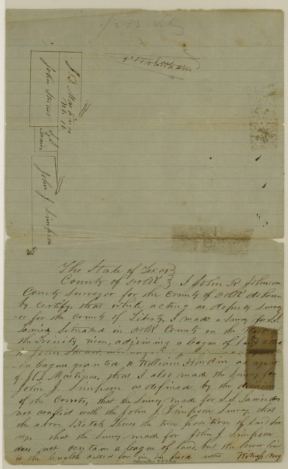
San Jacinto County Sketch File 4
[Sketch and explanation regarding the S.S. Lanier survey and surrounding area on the west side of the Trinity River in the southeast corner of the county]
-
Map/Doc
35700
-
Collection
General Map Collection
-
Object Dates
11/30/1857 (Creation Date)
12/11/1857 (File Date)
-
People and Organizations
John R. Johnson (Surveyor/Engineer)
-
Counties
San Jacinto
-
Subjects
Surveying Sketch File
-
Height x Width
12.9 x 7.9 inches
32.8 x 20.1 cm
-
Medium
paper, manuscript
-
Features
Trinity River
Part of: General Map Collection
[County table portion of 1879 State of Texas map by Pressler & Langermann]
![3102, [County table portion of 1879 State of Texas map by Pressler & Langermann], General Map Collection](https://historictexasmaps.com/wmedia_w700/maps/3102-1.tif.jpg)
Print $20.00
- Digital $50.00
[County table portion of 1879 State of Texas map by Pressler & Langermann]
1879
Size 15.0 x 23.6 inches
Map/Doc 3102

Baylor County

Print $40.00
- Digital $50.00
Baylor County
1917
Size 48.1 x 40.2 inches
Map/Doc 66714
Map showing survey for proposed ship channel from Brownsville to Brazos Santiago Pass

Print $20.00
- Digital $50.00
Map showing survey for proposed ship channel from Brownsville to Brazos Santiago Pass
1912
Size 18.4 x 28.8 inches
Map/Doc 72903
Leon County Working Sketch 60

Print $20.00
- Digital $50.00
Leon County Working Sketch 60
2005
Size 20.7 x 31.3 inches
Map/Doc 83575
Matagorda County NRC Article 33.136 Sketch 16

Digital $50.00
Matagorda County NRC Article 33.136 Sketch 16
2023
Map/Doc 97256
Val Verde County Sketch File Z16

Print $20.00
- Digital $50.00
Val Verde County Sketch File Z16
1905
Size 21.4 x 20.9 inches
Map/Doc 12557
Freestone County Working Sketch 8

Print $40.00
- Digital $50.00
Freestone County Working Sketch 8
1960
Size 60.6 x 36.6 inches
Map/Doc 69250
Eastland County Rolled Sketch 21

Print $20.00
- Digital $50.00
Eastland County Rolled Sketch 21
1982
Size 40.2 x 44.5 inches
Map/Doc 8827
[Sketch for Mineral Application 33721 - 33725 Incl. - Padre and Mustang Island]
![2873, [Sketch for Mineral Application 33721 - 33725 Incl. - Padre and Mustang Island], General Map Collection](https://historictexasmaps.com/wmedia_w700/maps/2873.tif.jpg)
Print $20.00
- Digital $50.00
[Sketch for Mineral Application 33721 - 33725 Incl. - Padre and Mustang Island]
1942
Size 26.6 x 22.7 inches
Map/Doc 2873
Angelina County Sketch File 24

Print $8.00
- Digital $50.00
Angelina County Sketch File 24
1893
Size 8.9 x 5.6 inches
Map/Doc 13065
Fayette County Working Sketch 5

Print $20.00
- Digital $50.00
Fayette County Working Sketch 5
1981
Size 16.2 x 14.6 inches
Map/Doc 69169
You may also like
Gregg County Rolled Sketch 13

Print $64.00
- Digital $50.00
Gregg County Rolled Sketch 13
1940
Size 10.5 x 15.5 inches
Map/Doc 45439
Red River County, Texas

Print $20.00
- Digital $50.00
Red River County, Texas
Size 22.2 x 17.2 inches
Map/Doc 95756
Flight Mission No. DIX-7P, Frame 90, Aransas County

Print $20.00
- Digital $50.00
Flight Mission No. DIX-7P, Frame 90, Aransas County
1956
Size 18.8 x 22.4 inches
Map/Doc 83884
Jones County Sketch File 13a

Print $4.00
- Digital $50.00
Jones County Sketch File 13a
Size 8.3 x 15.0 inches
Map/Doc 28499
Flight Mission No. CUG-2P, Frame 9, Kleberg County

Print $20.00
- Digital $50.00
Flight Mission No. CUG-2P, Frame 9, Kleberg County
1956
Size 18.6 x 22.2 inches
Map/Doc 86181
Dickens County

Print $20.00
- Digital $50.00
Dickens County
1891
Size 24.5 x 20.2 inches
Map/Doc 4533
Karnes County, Texas

Print $20.00
- Digital $50.00
Karnes County, Texas
1880
Size 28.9 x 23.0 inches
Map/Doc 524
Williamson County Working Sketch 14

Print $20.00
- Digital $50.00
Williamson County Working Sketch 14
1982
Size 22.0 x 28.3 inches
Map/Doc 72574
Brooks County Sketch File 9

Print $2.00
- Digital $50.00
Brooks County Sketch File 9
1988
Size 14.4 x 8.8 inches
Map/Doc 16571
Reagan County

Print $40.00
- Digital $50.00
Reagan County
1940
Size 50.5 x 37.7 inches
Map/Doc 78430
Mitchell Estate Subdivision

Print $20.00
- Digital $50.00
Mitchell Estate Subdivision
1953
Size 9.3 x 19.8 inches
Map/Doc 92505
Medina County Sketch File 19

Print $20.00
- Digital $50.00
Medina County Sketch File 19
1989
Size 32.5 x 21.0 inches
Map/Doc 12071